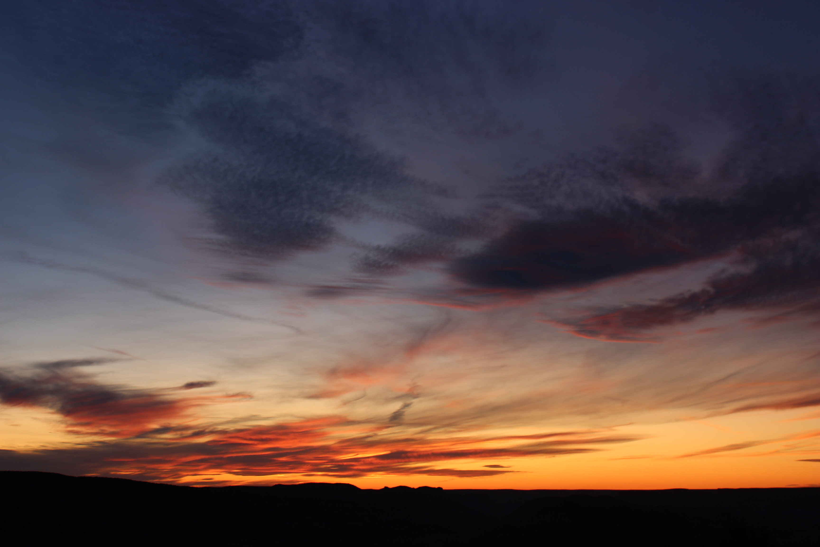
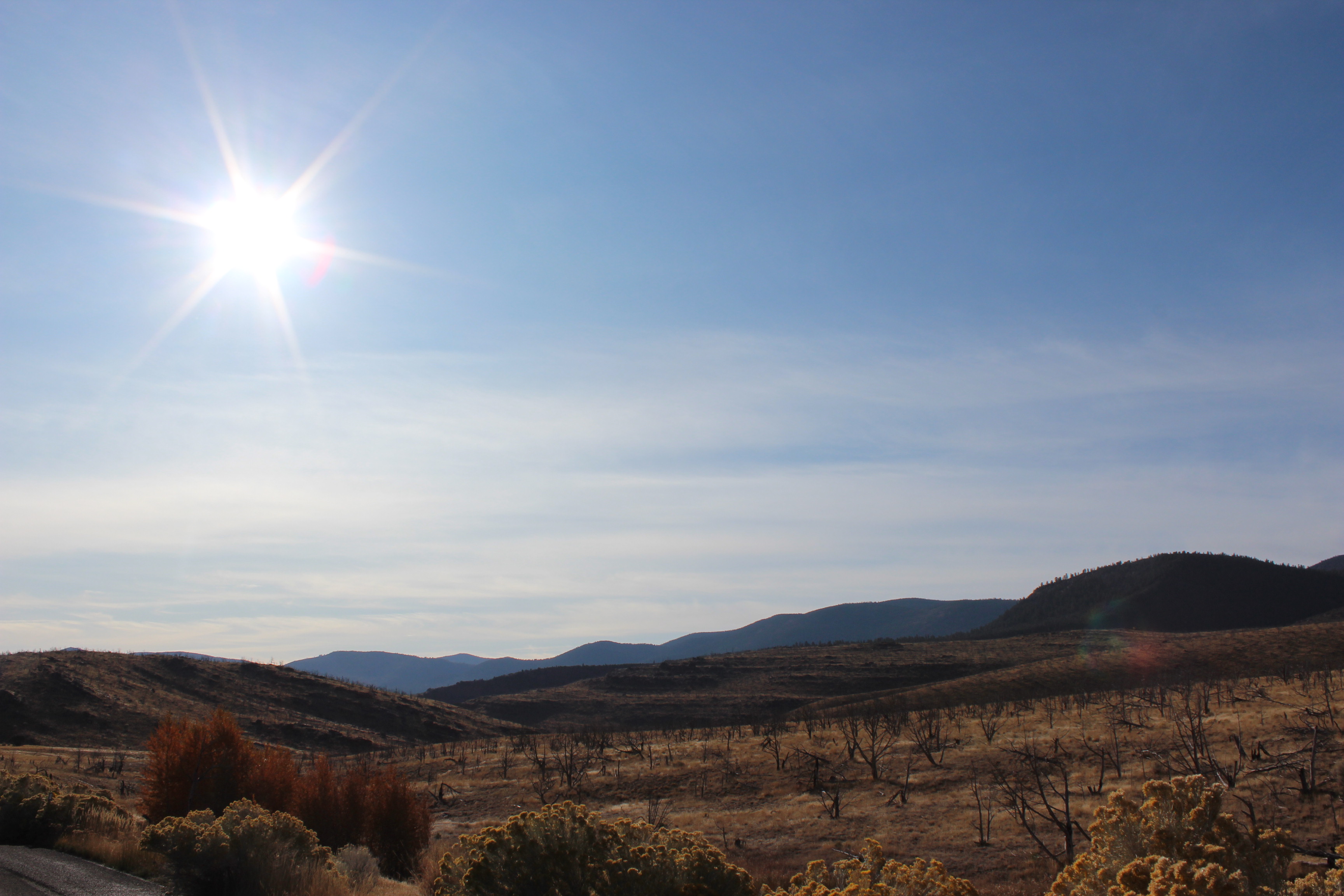
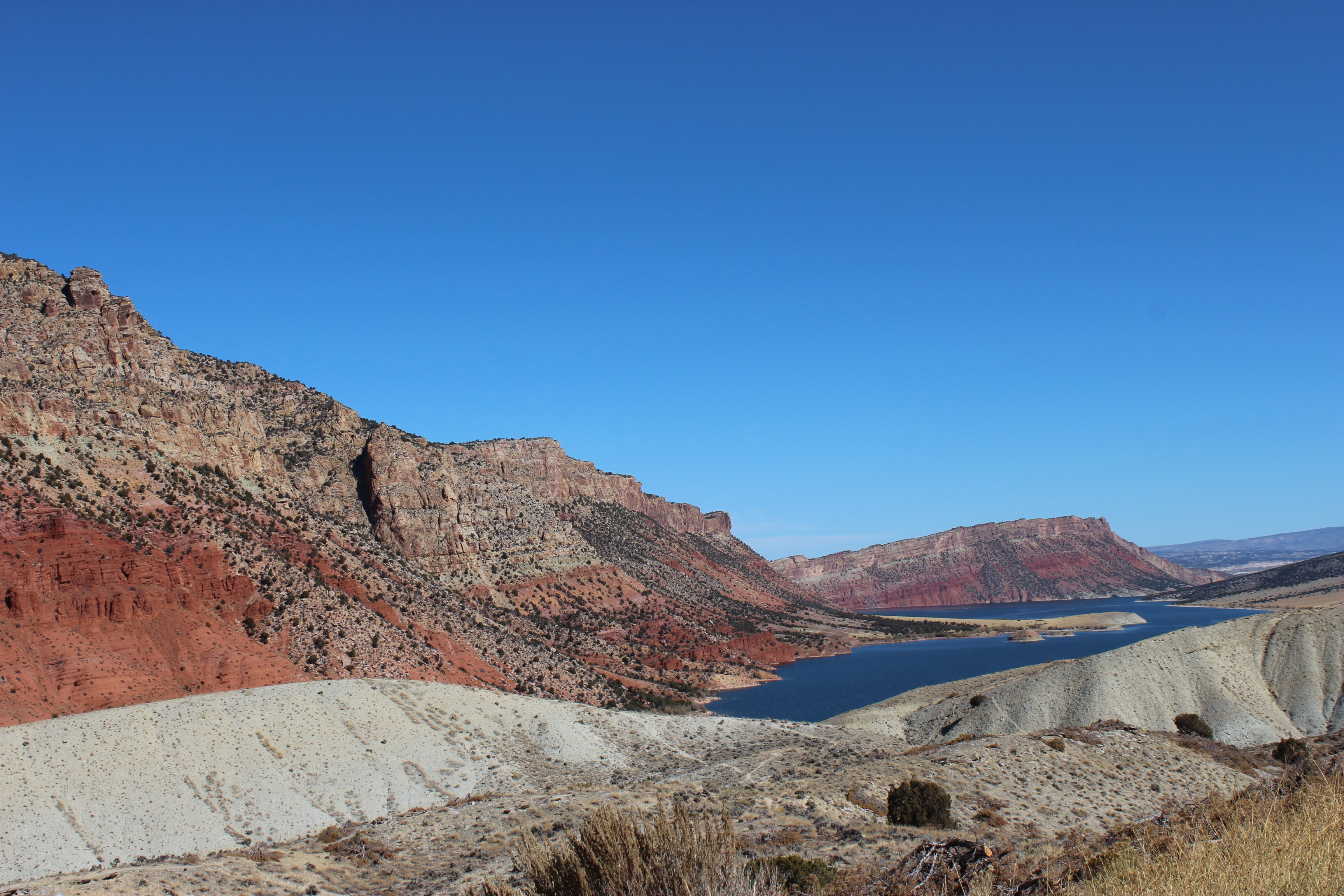
We finally made it to Utah! Flaming Gorge Reservoir had been on my bucket list since I moved out here, so Johnny and I drove the 3 hours to visit a few weekends ago. By the time we got to the reservoir, it was getting dark so we only got to stop at one overlook at first. After watching an incredible sunset, we made our way down the East side looking for a campsite. But, like we kept finding in the Grand Tetons, most of the campgrounds were closed. We drove to a few before finding Dripping Springs Campground. It had just gotten completely dark by the time we arrived — we were so thankful that we found this place! We had no idea what the landscape really looked like until we woke up. Quiet, cold, but beautiful scenery surrounded us, and only got better as we made our way out of the campground that morning. We were ready to explore.
The beautiful sunset we watched at Little Firehole Overlook, just inside Flaming Gorge Reservoir.The landscape we woke up to Sunday morning at Dripping Springs Campground.
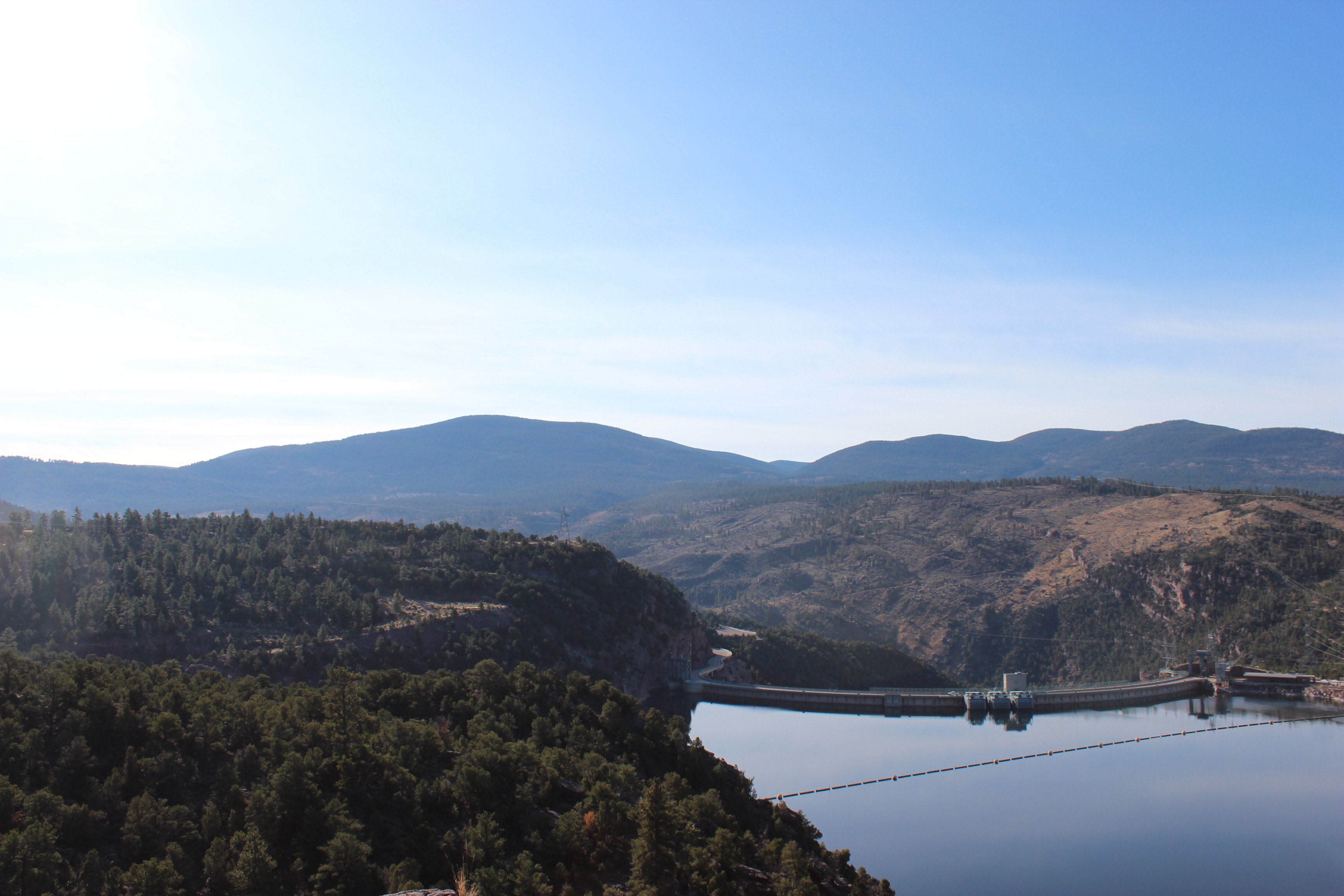
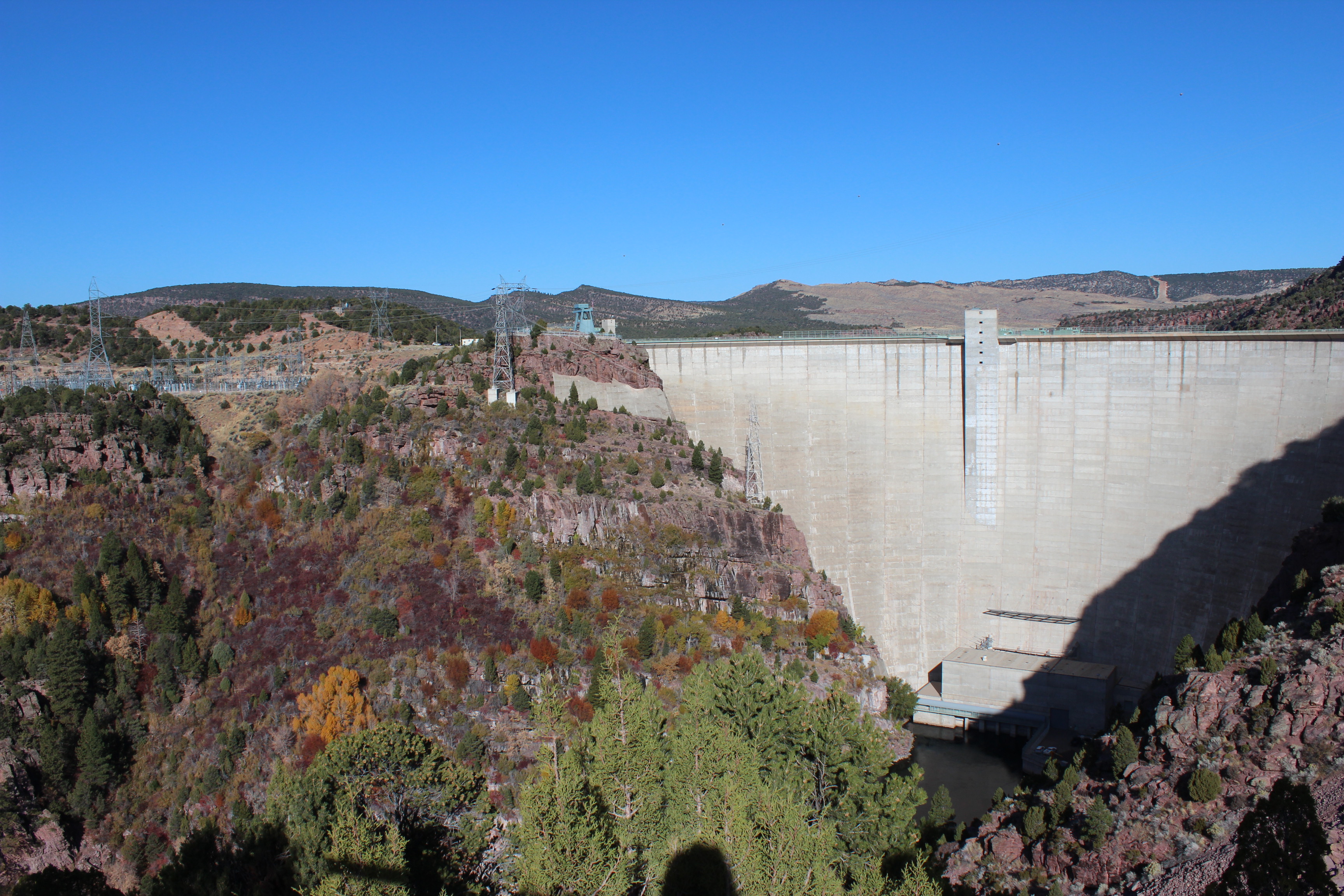
We drove down to see the Flaming Gorge Dam next, and were super impressed by its size. It stands 502 feet high and is a major source of water and hydroelectricity — water flows out of it at speeds up to 28,800 cubic feet per second. Thats over 215,400 gallons…
A view from the top of the dam. I loved how the bright yellow rabbitbrush contrasted with the dark colors behind it.502 feet up, the gorge looked massive.A view of the entire wall of Flaming Gorge Reservoir’s dam. Look at all those fall colors on the mountain!
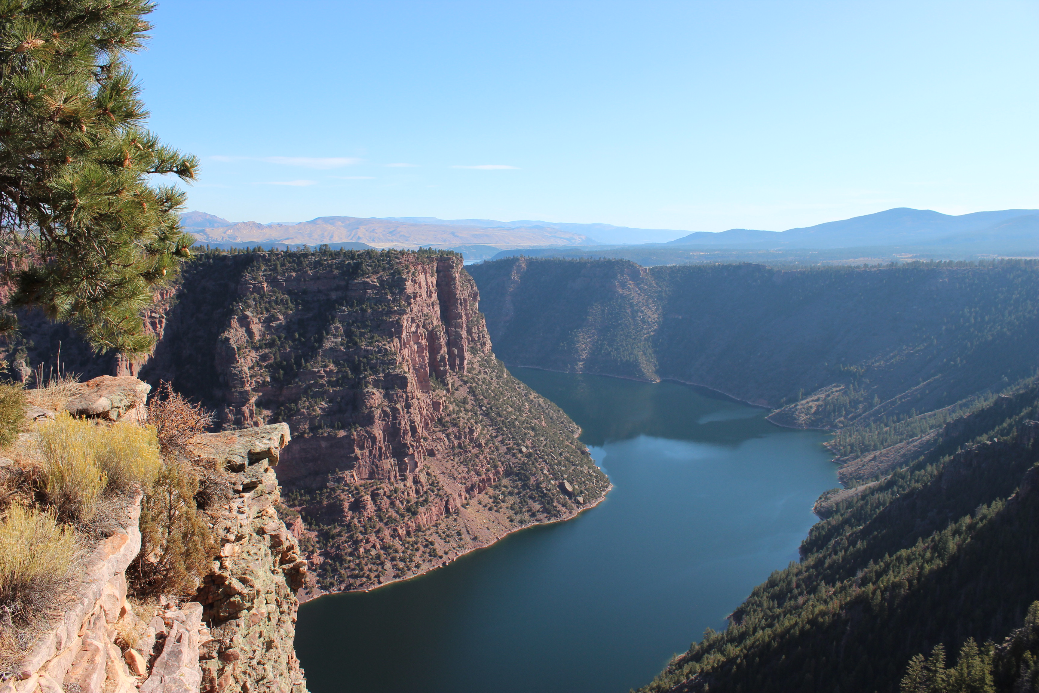
Our next stop was at the Red Canyon Visitor Center. I had looked up this beautiful overlook online, and thought that Johnny and I were going to have to hike over 9 miles to get to it. Turned out, there was a huge parking lot and a short paved path that went directly to it. 🙂
The view I had been waiting for, Red Canyon! This was definitely my favorite spot we stopped at that weekend.On the other side of the canyon, a cloud of smoke hung over the trees all day. It was all from fire crews that were doing prescribed burns around the South side of the gorge that day.
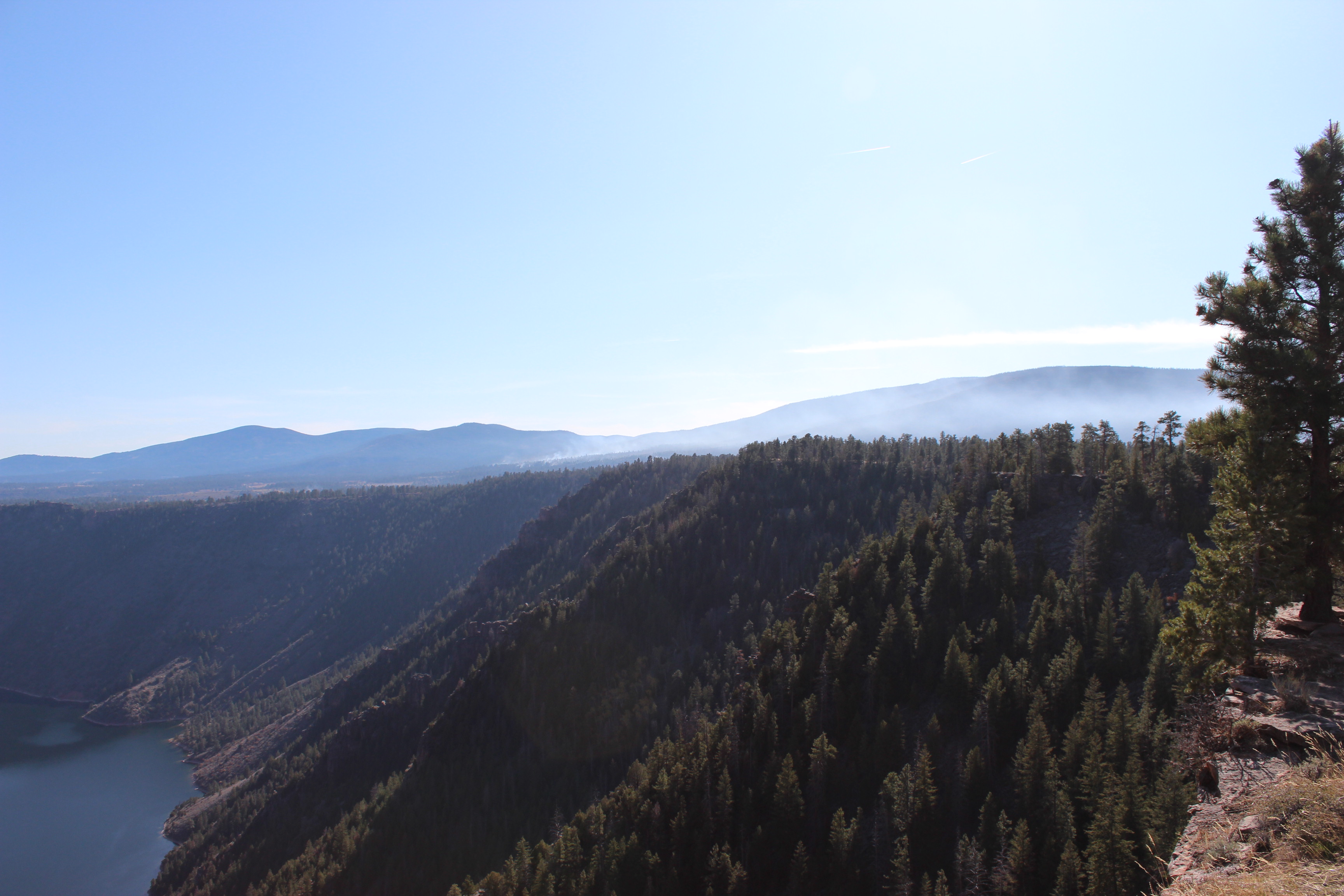
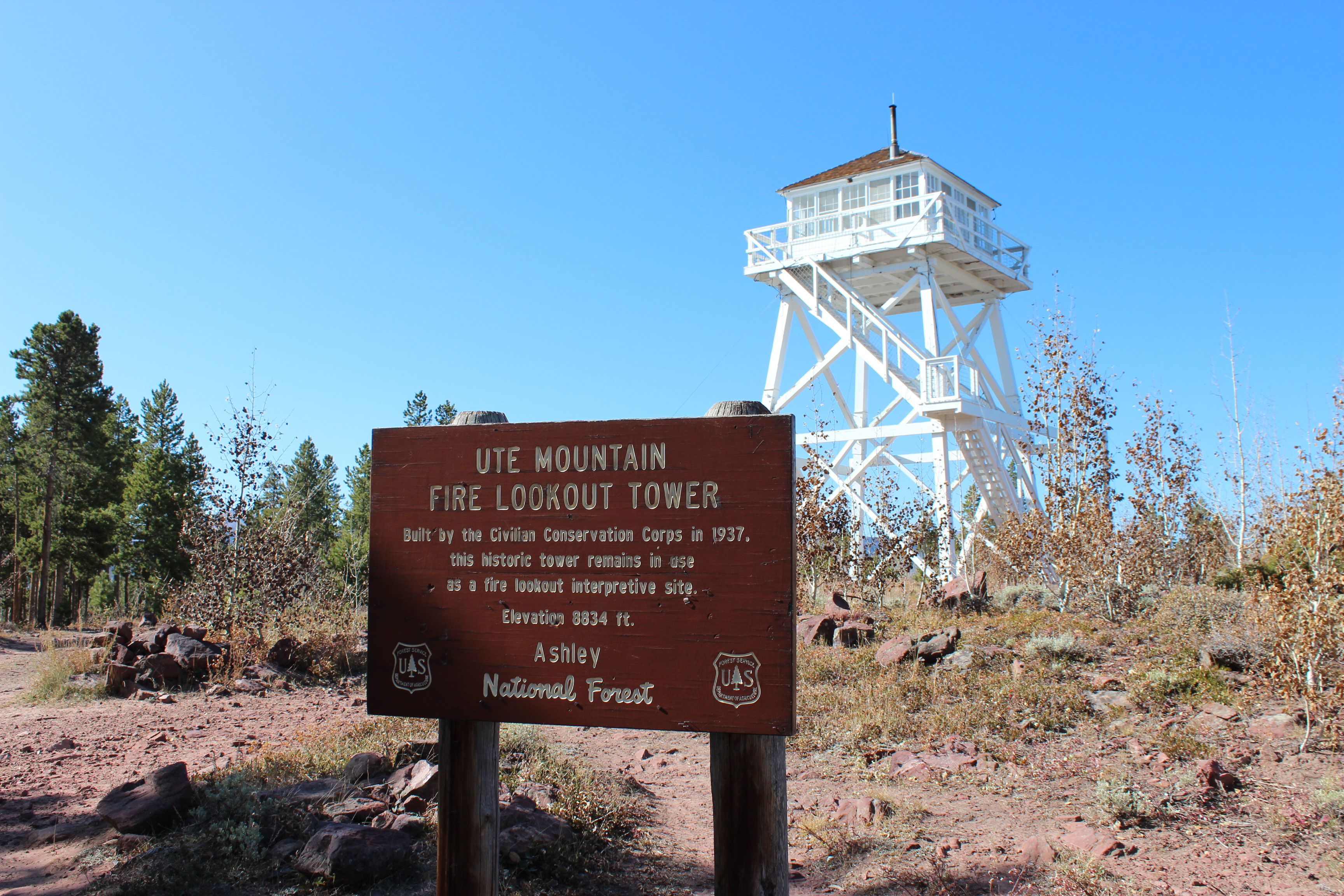
Once we got our photos of Red Canyon, we made our way to Ute Mountain Fire Lookout Tower on a whim. After what seemed like forever, we made it to the top of Ute Mountain only to find a closed lookout tower. (: We still don’t know why it was locked up, and were a bit disappointed. Apparently at the top of the tower, you get a 360 view of Ashley National Forest. Maybe next time.
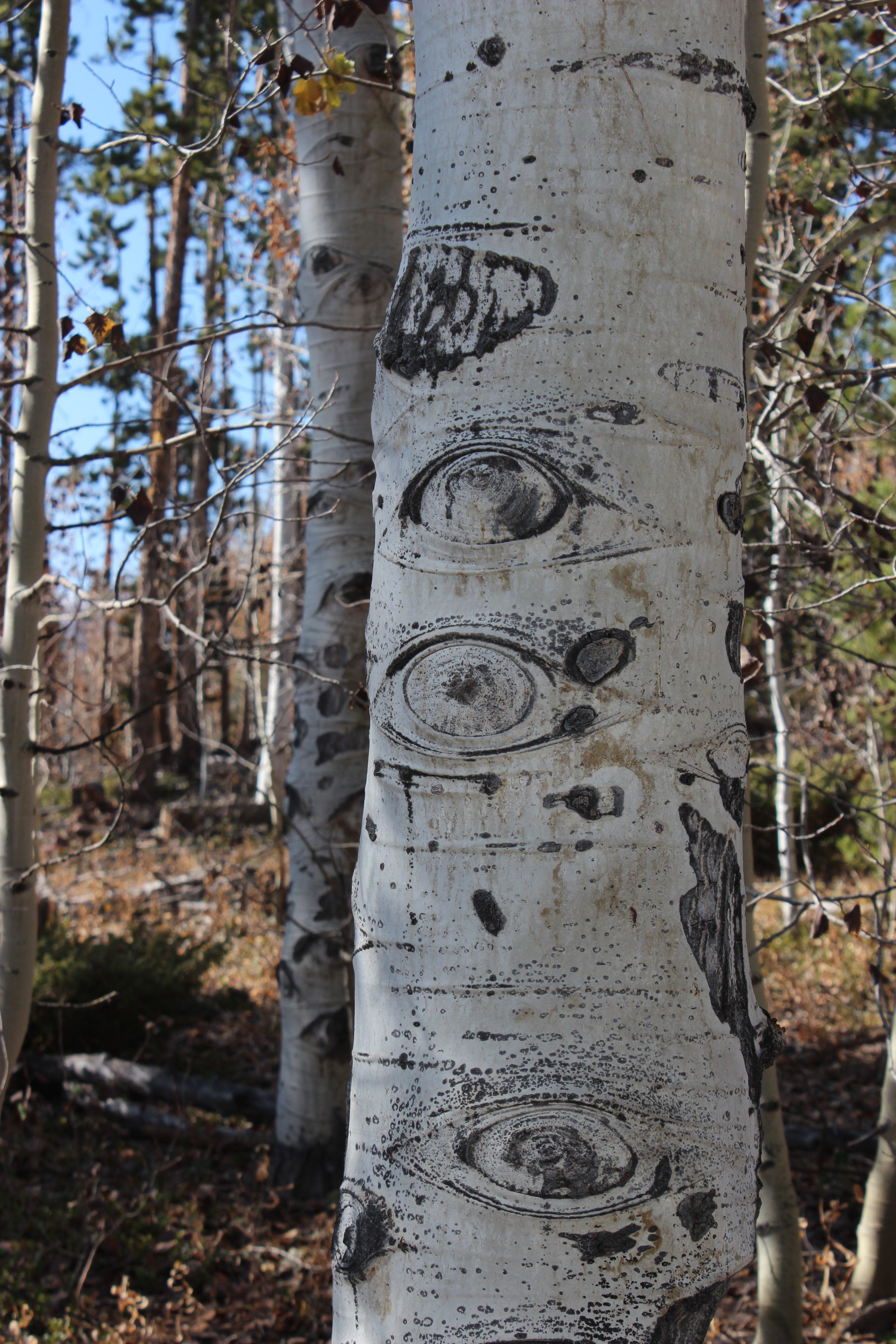
On our way up to Ute Mountain Fire Lookout Tower, I looked out into the aspen trees, only to find that they were looking back. 😉Ute Mountain Fire Lookout Tower — “Built by the Civilian Conservation Corps in 1937, this historic tower remains in use as a fire lookout interpretive site. Elevation 8,834 ft. Ashley National Forest”
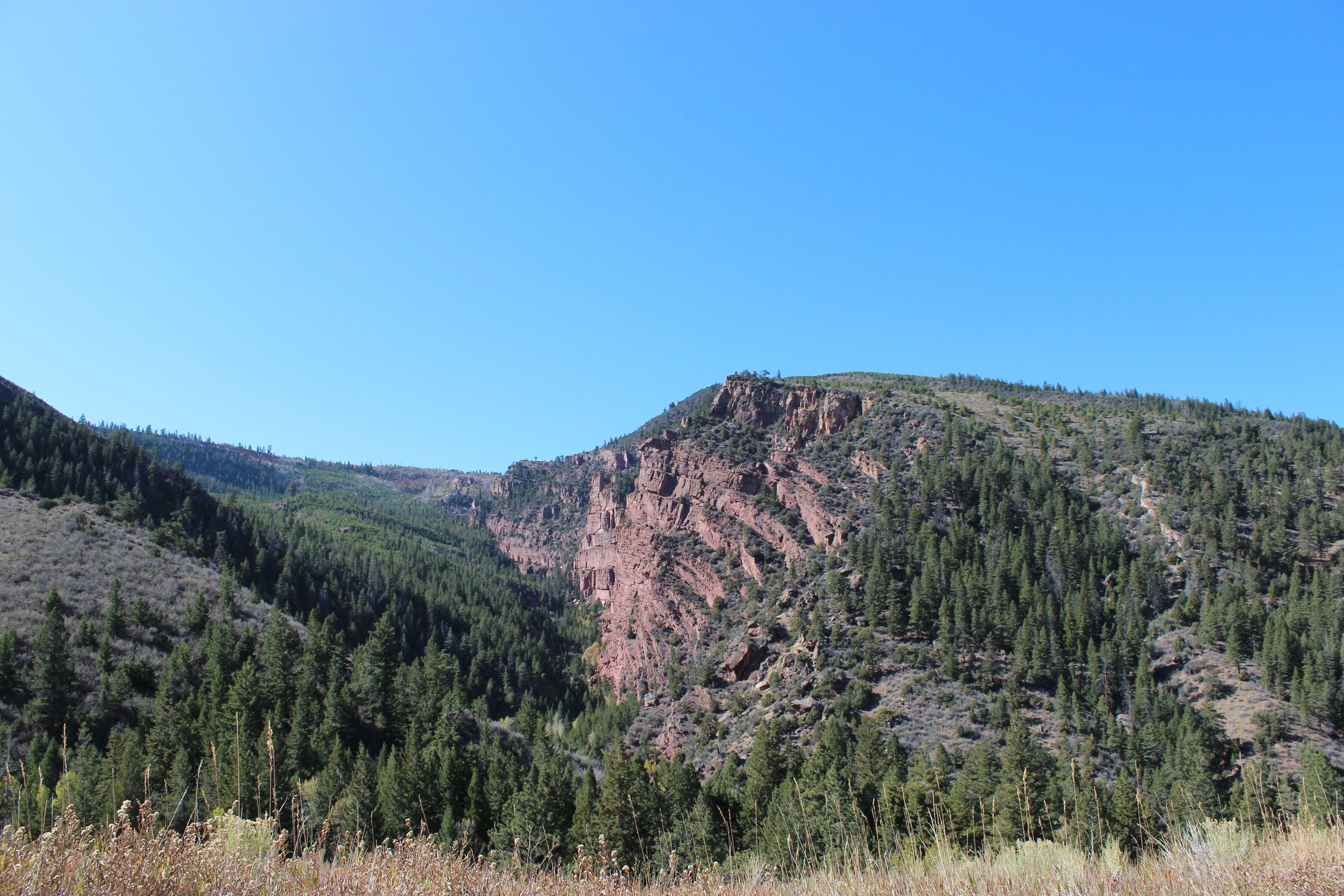
We then drove towards Sheep Creek Geological Loop in the Southwest corner of Flaming Gorge. This small loop travels through the Uinta Mountains, and was our last adventure in Utah. On the route, you can see the Uinta Fault and some really impressive rock structures that have resulted from the split.
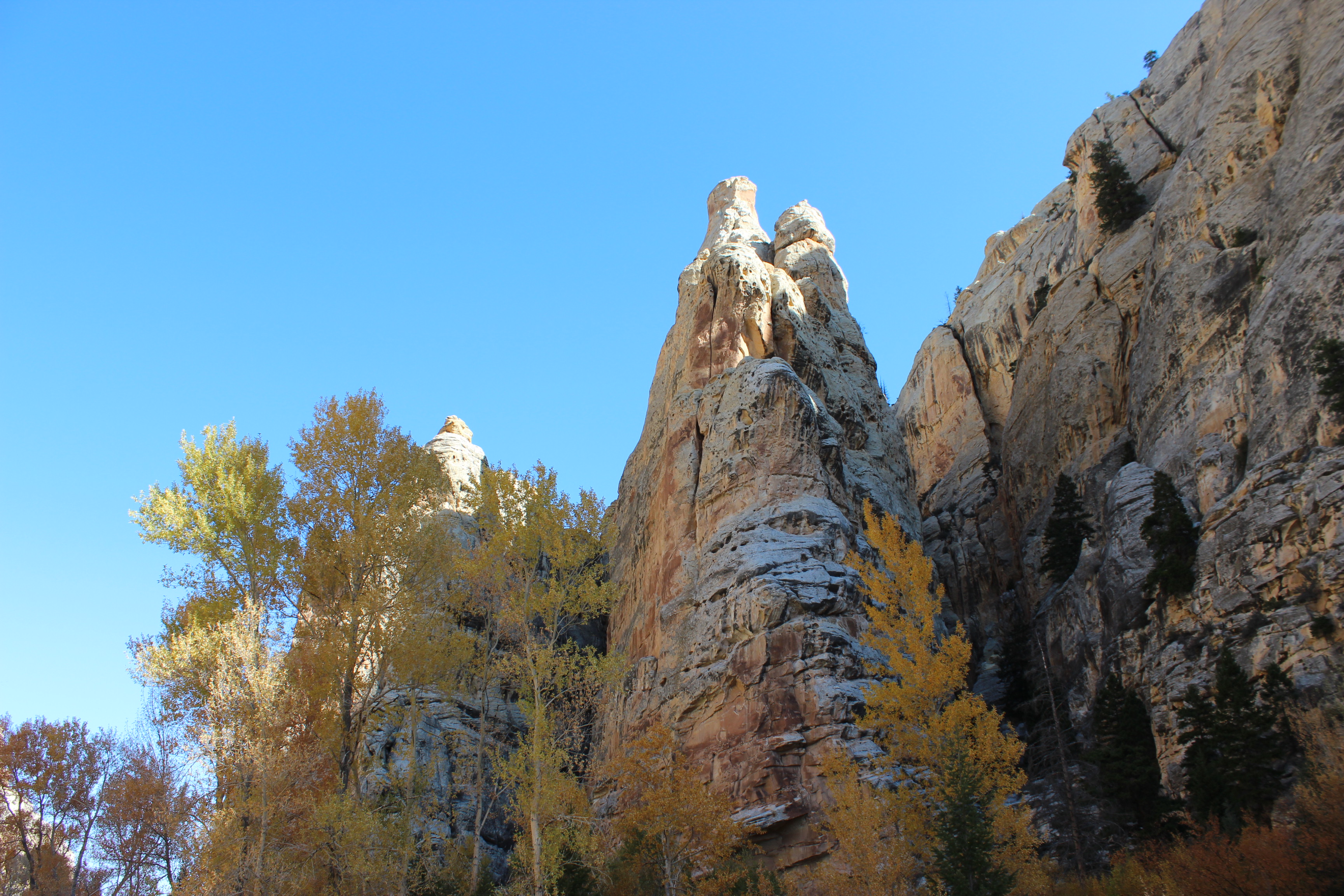
A very interesting mountain we saw on our way to the Sheep Creek Geological Loop.Tower Rock. This was my favorite rock structure we saw through the loop. I loved how the aspens were still in full fall color just beneath it!The unexpected musk ox? we saw on our way out of the Sheep Creek loop. I think this was my first time ever seeing this animal. This large, shaggy, mammal can be a used as a type of livestock for some families; it produces wool, meat, horns, and pelts.Another incredible view we saw of Eastern Utah, just before leaving the state.
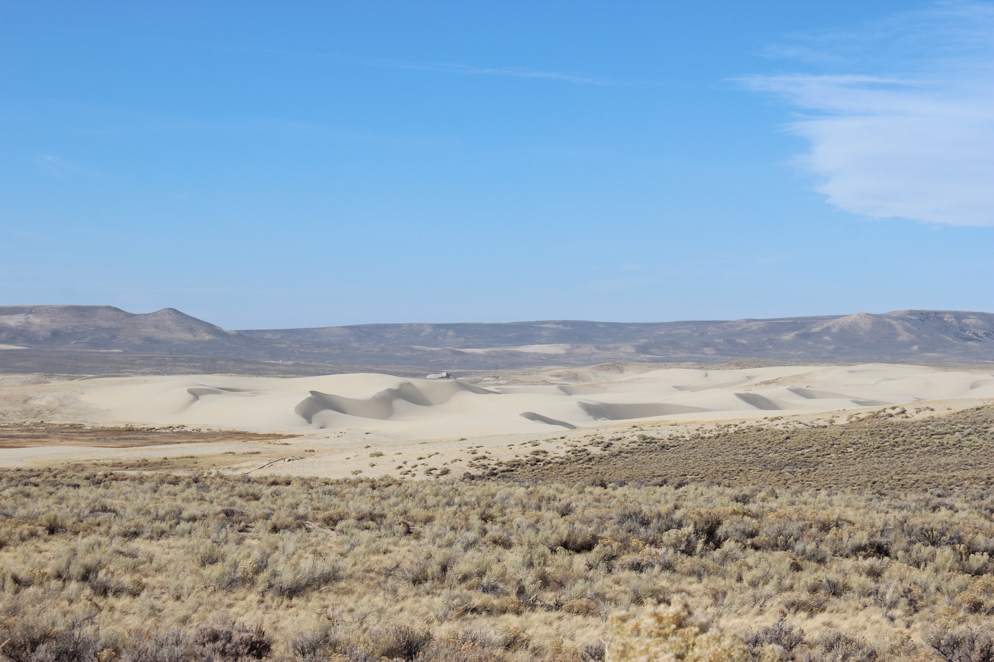
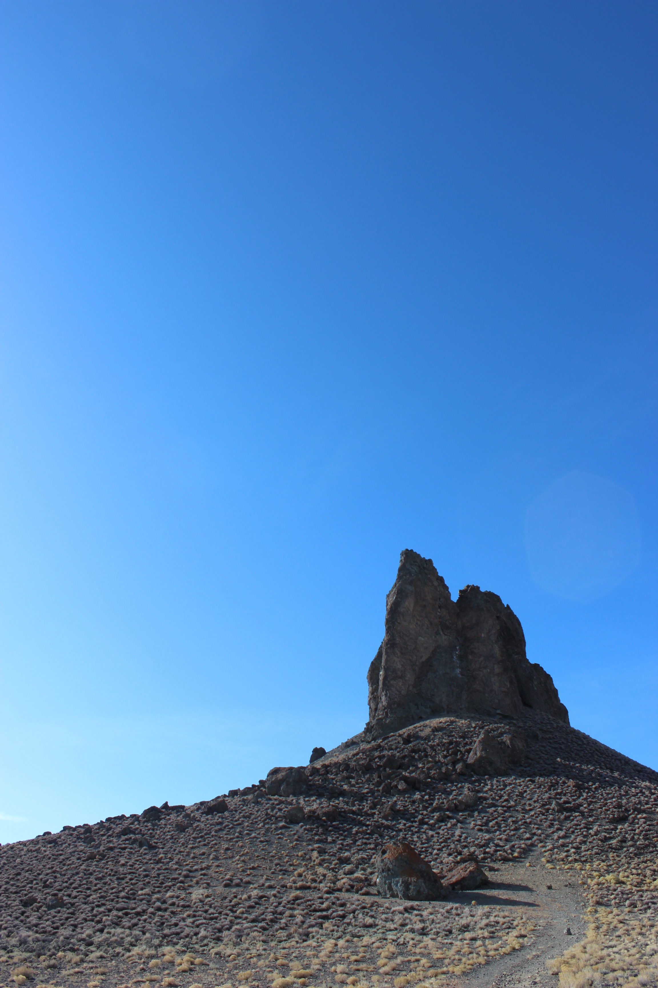
On our way back North to Wyoming, I still had a few stops in mind that I hadn’t made it to yet. Between Rock Springs and Lander, we took some sketchy dirt roads and two tracks to find the Killpecker Sand Dunes, and Boar’s Tusk.
The giant sand dunes in Sweetwater County, WY. Nearby, there was a huge spot designated for overnight camping and parking. The dunes are a popular spot for ATVs and dirt bikes to traverse through, it sounded like so much fun!Boar’s Tusk. This is the 400 foot core of a dormant volcano. It is made of an uncommon volcanic rock called lamproite, and dates back 2.5 million years ago.
I loved Utah, and luckily, this was just the start of our adventures in the state. A couple of weeks later, we went back to see the Great Salt Lake and Bonneville Salt Flats. That will be in an upcoming blog post. 🙂 I have about three weeks left here, and am feeling the time crunch more and more. There are just not enough hours in the day to accomplish everything on my list, and picking and choosing between sites is the hardest thing! I have become so thankful that Lander is so central though. It has really been a great, convenient location for all of our weekend adventures. Until next time. 🙂
After a few quick weeks of work, I was ready for another trip to the Grand Tetons and Yellowstone. Lucky for me, one of my best friends from childhood was coming to visit! Christina and her boyfriend stayed for a long weekend, and gave me the perfect reason to go back. I made the 2+ hour drive to Casper Friday night, and showed them around Lander Saturday. We woke up super early that Sunday morning and made our way into Grand Teton National Park by noon. Just before we got to the entrance, we noticed a large group of cars stopped on the side of the road. We pulled over at the last second, and were lucky enough to see a mother grizzly bear and her cub. Seeing these bears was a dream come true! The picture I got is still surreal. Apparently, the female grizzlies in the park have been learning to keep closer to the roads in order to protect their offspring. The male bears don’t like to go towards people, and so the females are more likely to protect their cubs. After taking several photos, we continued our journey, stopping at several scenic roadside attractions and lookouts along the way.
The female grizzly bear and cub that we saw just outside of Grand Teton National Park. Their scientific name is Ursus arctos.A cute picture of Johnny and me, in front of the Grand Tetons.
We then made it down to Jenny Lake, one of my favorite spots of the park, and took a short walk around the water. This was where we started to realize that a lot of the buildings and stores inside the park were closing… that day. We struggled to find a place to get dinner at on our way into Yellowstone, so we ended up backtracking to Signal Mountain Lodge. We enjoyed a quick dinner with an awesome view before getting back on the road.
Jenny Lake. One of the must-sees in the park.
We started to get worried that we wouldn’t find an open campground, especially since we were relying on walk-up sites. We must have passed at least a half dozen closed campsites before we found one to stay at, conveniently right in between the two parks’ entrances. Just as the sun started to fall, we set up our tent and fire at Sheffield Creek. It got below 20 degrees that night — definitely the coldest temperatures I have ever slept in! Fortunately for us, Johnny’s boss let us borrow a portable space heater, and we all had insulated thermal sleeping bags. It was cold, but we survived and woke up to a beautiful new landscape.
Our perfect little spot, with a fire pit, bear box, and even some leftover wood from past campers.The sun set quick that afternoon, as we hurried to set up camp before nightfall.
We woke up to a frosty wonderland. Every surface and object had a thin white coating, and everything was sparkling. I had plenty of time to take some photos while we waited for the tent and car to thaw out. Once we had breakfast, and a few visits from the surrounding wildlife, we were ready to start our adventure in Yellowstone.
Tree silhouettes in the morning fog.The state of my car’s windows after a night below 20 degrees.The coyote(?) we saw that morning, right as we started cooking breakfast. Thankfully, it wasn’t interested in our food, and was stalking something in the field instead.I have no idea what kind of plant this is, but was captured by its sparkle.An ice formation I found on the road at the campground. I love all the organic shapes!Campsite #6, the best campsite. 😉Sheffield Creek Campground, Grand Teton National Forest. Apparently this was one of the few sites that are open in early October!A raven, or Corvus corax, perched right above our campsite. I wish I could attach a video so you could hear the noises it was making! I had never heard this kind of bird click and sing like this one did.
In Yellowstone we stopped at the West Thumb Geyser Basin, Kepler Cascades, Old Faithful, Grand Prismatic Spring, Firehole Falls, Beryl Spring, Artists Paintpots, Mammoth Springs, and the Roosevelt Arch. Our. day. was. packed. I was so happy that I got to see some new things in Yellowstone, but was definitely exhausted by the end of the day. After a quick stop in Gardiner, Montana, we made the 6.5 hour drive home to Lander.
Johnny, Chris, and Christina at West Thumb Geyser Basin.The ravens in Yellowstone were like pigeons. This one let me get scary-close.The view of Grand Prismatic I had been waiting for. We walked just over half a mile to see the spring from above. What a dream come true.The huge heard of bison we saw on our way to Artists Paintpots.A couple of the hot springs at Artists Paintpots. This was one of the few sites I hadn’t seen yet, and was thrilled to get to explore it!One of the bubbling mud pits at Artists Paintpots.Almost anywhere you look in Yellowstone could be on a postcard.One of the male elk we saw near the North Entrance of Yellowstone National Park. I still think these are some of the prettiest mammals out here.Another new site for me to see, the Roosevelt Arch. It reads: “FOR THE BENEFIT AND ENJOYMENT OF THE PEOPLE.” Yellowstone was the first national park in the United States, and this was the first major entrance to it. What a neat piece of history to visit.Johnny and me in front of the Yellowstone sign in Gardiner, Montana. ♥
I would still go back to Yellowstone or the Grand Tetons any time, but lately, we have started branching out of Wyoming more. Over the next few weekends, Johnny and I visited Utah, Colorado, and more of Wyoming. I am behind on sharing so many of our adventures, but they’re still so fun to write about. I am so happy I will have these to go back to and read in the future. 🙂
After my first trip to the Grand Tetons and Yellowstone, I stayed busy at work continuing my rangeland monitoring routines. The cattle have been steadily transitioning out of the summer range allotments for the past month, so, many of the pastures within them are completely empty now. It has become the new norm to hardly see any cattle out in the field, but this means that we can focus on studying the patterns of vegetation heights in individual pastures. Lately, we have been in an allotment called Silver Creek. It has four pastures within it: Strawberry, McLean Meadows, Sweetwater Canyon, and Rocky Draw. As of right now, we’ve finished monitoring all but the very last one! We monitor them by mapping the grazing/utilization patterns. This requires us to venture around an entire pasture as much as possible. Whether we are in the truck or on foot, we are constantly observing the vegetation to determine what percentage has been grazed, and therefore, what percentage has been utilized. Once we agree on a number, we then mark the patterns we see on a huge map with colored pencils. This has definitely been one of my favorite responsibilities of my internship, especially considering all of the wildlife we’ve seen in Silver Creek. This includes more greater short-horned lizards, birds of prey, a badger, a prairie dog, and finally, two moose!
Our utilization map of Silver Creek when we had just completed Strawberry and McLean Meadows pastures. Sweetwater Canyon is the blank pasture at the bottom of the map, and Rocky Draw is the one in the top right corner. Another greater short-horned lizard, or Phrynosomahernandesi, we found in McLean Meadows. This one I was able to catch and hold for a few seconds.Pausing for a moment to admire where we were and what we were seeing. Jon got this photo of the wind practically taking me away, haha.
Mid-September-ish, we were able to get one last autumn camping trip in before the cold really came to Lander. A few of my Wyoming coworkers and friends joined me and Johnny at Worthen Meadows Reservoir in Shoshone National Forest one weekend! We found the most perfect campsite right on the water, got a fun hike in, grilled burgers, and saw a really beautiful sunset. We had the best time!
Our campsite — literally right on the water. 🙂 We had our own picnic area, grill, and bear box. The best part was that this campsite wasn’t in season, so staying there was free!The incredible sunset we caught on Worthen Meadows Reservoir.
In the following weeks, the autumn colors started to pop out everywhere in Lander and around our BLM field office. It had literally been a dream of mine to see aspen trees in the fall, but for some reason, I had only thought that they grew in Colorado. I was incredibly surprised when I saw them out here and realised that I would still be here to watch them change. Needless to say, I was out there almost everyday taking pictures. The landscapes turned magical, but soon after the leaves turned yellow, they were falling to the ground. I swear it changed from fall to winter in a matter of days — we have already gotten several snow storms!
One of my favorite parts of our picturesque route home from Antelope Hills Allotment.Catching the sunset above an aspen grove just outside of Atlantic City.
While we were monitoring our third pasture of Silver Creek Allotment, Sweetwater Canyon, our timing couldn’t have been more perfect. We got to see several shrubs and tree species in their fall colors, and some incredible wildlife. On our way home one day, we came across a small family of prairie dogs, as well as a badger, all in a span of a couple miles.
The incredible view at the top of Sweetwater Canyon.The curious prairie dog we saw on our way home. I think this scientific name is Cynomys ludovicianus.The first good photo of a badger, or Taxidea taxus, I have been able to get in Wyoming!
The other week, I got to go out in the field with another one of the BLM’s rangeland specialists. Along with his main job responsibilities, Steve is in charge of collecting a few rain gauge and mercury samples for the National Atmospheric Deposition Program. This program, run by the National Trends Network, collects samples from all over the United States (and further). They study the bases, acids, and nutrients in nationwide precipitation in order to show trends over time. This was so fun for me to assist with because, earlier this summer, I was exposed to this program in Shenandoah National Forest! My Chemistry class took a field trip to the Big Meadows NADP site near my university. We learned about the same rain gauges, as well as various other equipment that the NTN uses.
The huge mass of snow and fog clouds that rested in Sinks Canyon that Tuesday.This is one type of rain gauge provided by the NADP. A small black box extending from the surface of the table has a metal plate attached to it. Once it senses any sort of precipitation, the gray shelf will slide up off the rain collector bucket so that the total rainfall can be contained and measured. The only downside to this piece of equipment is that it cannot always pick up light precipitation, and so it may show slightly lower precipitation values than expected.This was one of the South Pass City NADP sites we went to that Tuesday. This site is completely solar powered, and can accumulate snow as high as the fences that surround it! Steve said that in the winter, he often has to snowshoe in from a main road. Apparently, this spot is notorious for moose, but we didn’t see any that day.
The first NADP site we went to that morning was in Sinks Canyon State Park, one of my favorite places. Usually it’s a bit colder there in the mountains than in Lander, but that day, it was so cold that it was snowing! After work, I went back to take some photographs of the snow and fog that had settled throughout the day. I included just a couple below.
Interrupted.The deer were scaling the mountain like it was nothing. This group had at least a dozen members in it.Snowy evergreens — one of my favorite parts of winter.
Our Sweetwater Canyon monitoring still wasn’t complete until later that week when we hiked along the riparian land down in the canyon. This ended up being a 9+ mile hike, and so much fun. We saw a few snakes, two moose, and an abundance of heavily grazed land. Our team started on the East side of the canyon, while a second team started on the West side. The idea was to meet in the middle if possible, in order to map the entire riparian zone. Along the way, each team had several photo points to take for the rangeland specialists, and a few transects to run. We were also noting anything strange, unexpected, or over-utilized. The canyon seemed like it had been a paradise for the cows, with endless shade spots, water, and vegetation.
Our view for most of the 9 mile hike we took through Sweetwater Canyon.This picture may look weird and gross because there are two snakes here! We found a larger snake swallowing a smaller one whole. Ick.
Our CLM Blog has been down for a couple of weeks, so this post is pretty late. The photograph that I found from the field below is one that I love, but have no idea where I took it. A bald eagle, or Haliaeetus leucocephalus, had been standing in a field we drove through, right next to a golden eagle, or Aquila chrysaetos. I was blown away by these magnificent birds. Usually, bald eagles live along rivers, or bodies of water, so I don’t know why this one was seemingly in the middle of nowhere. He took flight, and flew right alongside us for a half mile or so down the road. Just a couple of dreamy minutes. Another blog post or two will be following this one — so much is happening in my last month here. 🙂
My favorite bird of prey. We could spot him from a mile away. 🙂
We woke Sunday up to a completely different world. The fog and the steam from all the geysers and hot springs seemed to melt together into one big cloud, leaving us with an ominously magical morning in Yellowstone. With hardly any people out so early, we quickly made it to our first site around the Upper Loop, Nymph Lake. The air was chilly and refreshing, and made a perfect setting for the view.
Seemingly endless clouds surrounded us and the mountains Sunday morning. Snake River had practically transformed overnight.It was so foggy that we could hardly make out the ridge-line of the mountains during several parts of the drive. An incredible view of Nymph Lake from an overlook.Just to the right of the lake, you can see its steam joining the rest of the fog.
After several photos at Nymph Lake, we started to make our way to the next two stops: Roaring Mountain and Sheepeater Cliff. All of a sudden I hear a collective “buffalo!” and look to see a massive adult right in front of our car. I was thrilled (and safe in our rental car) and managed to take a really great picture of him from my window. This species of buffalo can get up to 6 feet in height, weigh over 2,000 pounds, and run at speeds up to 40 mph. He was literally as big as our SUV. And, as quickly as he appeared, he vanished into the trees when a large truck drove up behind us. Soon after, we arrived at Roaring Mountain, a structure made out of volcanic rhyolite rock. Apparently, it sits on a spot where magma flows closer to the surface of the earth than usual, creating steam vents all over the face of the mountain. Our next stop was at Sheepeater Cliff, an interesting, columnar rock structure formed from cooling basalt lava. It was named after a group of Shoshone Native Americans or the “Sheepeaters” for their use of bighorn sheep.
The American bison that walked right by our car; our timing could not have been any better.A photo of Roaring Mountain steaming from several different cracks in the rock’s surface. The steam you see is Hydrogen sulfide gas, which causes the water runoff to be acidic. This dissolves the rhyolite rock overtime, removing minerals and leaving behind a type of clay called kaolinite. Roaring Mountain is now so covered in this white mineral, that it almost looks like snowfall.A section of Obsidian Creek, seen on our way from Roaring Mountain to Sheepeater Cliff. This unique part of the creek was completely covered by some sort of vegetation.Sheepeater Cliff. Look at those rock columns!
After our first few stops, we were ready to find Mammoth Hot Springs, a spot one of my uncles highly recommended. We pulled over briefly to see Golden Gate Canyon on our way, and even saw another lone bison shortly after. When we got to Mammoth Hot Springs site, there were elk everywhere. This was our first time seeing a male elk, and we even got to watch and hear him bugle. We explored the Lower Terrace Area of Mammoth Hot Springs, and were particularly amazed at the Palette Spring Terraces. The limestone rock in the terraces gets dissolved deep in the earth and then deposited on the surface again, forming stair-like structures.
The second lone male bison we found last Sunday. Apparently, bulls spend most of their lives alone, or in small groups with other bulls.The approach to the Mammoth Hot Springs’ Lower Terrace Area. You can see these limestone formations steaming from the carbon dioxide escaping.A limestone formation in Mammoth Hot Springs called Palette Spring Terraces. Several different colors appear due to more thermophile bacteria, just like at Grand Prismatic.
We then went on to look at a few more sites, ending up at the Lower and Upper Falls of the Grand Canyon of Yellowstone. We decided to take the hike down several switchbacks to an overlook that brings you to a platform right at the top of the Lower Falls. The Yellowstone River plummets down 308 feet at this point, with a force between 5,000 and 63,500 gallons per second. This makes the Lower Falls the tallest waterfall in the park! As you can see from the photo below, it was seriously impressive. This was my favorite walk of the day, and maybe the whole trip. I have never been so close to falls that powerful before, and really enjoyed the view of the canyon from the platform.
After taking the 0.4 mile Brink of the Lower Falls Trail down the canyon, we arrived to a platform right at the top of the falls. At this point, the water in the Yellowstone River falls 308 feet down the Grand Canyon of Yellowstone.The Grand Canyon of Yellowstone, carved out by erosion and water. It is estimated to date back ten to fourteen thousand years ago.
We had just one more stop on our Yellowstone list at this point in the trip, before we had to head back to Lander. We wanted to stop at the Mud Volcano springs and fumaroles site. Most of the hot springs here were pools of bubbling mud, and the fumaroles released an awful smelling mixture of hydrogen sulfide and carbon dioxide gases. But, this place was so cool. One hot spring in particular, called Dragon’s Mouth, literally sounded like it was roaring at you.
We saw our first large herd of bison on our way to the Mud Volcano site! Traffic was stopped for a mile or so, giving everyone the opportunity to snap some photos while passing them.Even though they were super muddy, some of the hot springs here were still beautiful.A photograph of the steam leaving Dragon’s Mouth at the Mud Volcano site. I swear those two rocks at the base of the cave look like teeth.The actual “Mud Volcano” at the Mud Volcano site. In 1870, explorers found a 30 foot cone here that would spew mud, covering nearby trees. Two years later, the volcano ruptured and left a large bubbling pit of mud in its place.
With that, our Yellowstone adventure came to an end. We headed back down South through the Grand Tetons, and then out its East entrance towards Lander. While we did a whole lot of exploring, there were still so many sites and hikes left in the park that we couldn’t fit into our schedule. I think anyone could spend weeks out there and never run out of things to do. This weekend was one of my favorite weekends yet in Wyoming, and I can’t wait to go back to the parks in October. Until next time. 🙂
One of the many tree stands affected by fire in the park. This was seen on our way back into Grand Teton National Park, right before we got to West Thumb Geyser Basin in Yellowstone.Finally! We got our view of the Teton peaks in all of their glory on our way home to Lander.
My first-ever adventure to the Grand Tetons and Yellowstone National Park last weekend was soooo fun. My parents came out all the way from Virginia to visit, and we had the best time exploring new territory, crossing things off our bucket lists left and right. We were able to spend all of Thursday showing them around Lander, but once Friday came, we were ready to get on the road. En route to the East entrance of Grand Teton National Park, we drove through a small town called Dubois about an hour and fifteen minutes into the drive. It was my first time seeing it, and it had some awesome features in it like an antler arch, and huge teepees. It didn’t take us much time to get through town, so we started the next leg of our journey shortly after taking a few photos.
The huge antler arch in Dubois, Wyoming. I’ve heard this arch is small though, compared to a similar structure in Jackson.Some incredibly patterned teepees we found a bit deeper into town. Native Americans’ relationships with buffalo were more than just predator-prey connections. The American buffalo were a huge part of their spiritual life, as well as a provider of clothing and weapon materials.A photograph of some of the landscape on the way to the Grand Tetons. We had a lot of overcast weather on our trip, but it didn’t ruin our experience in the least. 🙂
Once we got to the Tetons, traffic moved a lot slower. Even with it being off season, there were still a lot of other tourists that were wandering around the park. Our first stop was at Jenny Lake, and thankfully, we made it there just in time between two rain showers. We didn’t think a hike was going to work out because of the weather, so we spent a couple of hours walking around the lake and enjoying the views instead. When we noticed the drizzle starting up again, we found our way back to the car. We then went to Jackson Lake Lodge, and enjoyed drinks and some food at their restaurant called Blue Heron Lodge. Plus, we had an incredible view of the Tetons at our table. After a while, the rain subsided again and we left to go find dinner and our cabin for the night. We stayed in a cute little two-bedroom cabin in Colter Bay Village, and were even able to take a walk around the Colter Bay and Jackson Lake before it got dark.
There are approximately 61 species of mammals that live in Grand Teton National Park. About 100 of those individuals get killed each year due to vehicular collisions; this sign was a great reminder to take our time and enjoy the views.One of my favorite pictures taken at Jenny Lake, in Grand Teton National Park. I loved all of the color variations in the rocks on shore!An ominous view of the Tetons from Colter Bay Village from last Friday. It was so overcast that weekend that we didn’t get a chance to see the top of the mountain peaks until Sunday morning.We woke up early last Saturday in order to make it to a majority of Yellowstone’s Lower Loop sites. On our way out, we finally got a good picture of Grand Teton National Park’s road sign. 🙂
A short distance from the Teton’s North entrance, we made it into Yellowstone. Our first major stop was at the West Thumb Geyser Basin. A one-mile boardwalk trail lead us around several geysers, hot springs, and thermal pools and cones. Apparently, these features pour over 3,000 gallons of hot water into Yellowstone Lake every day. This was such a cool way to start our adventure — I had no idea the park had so many geysers. There are about 500 in Yellowstone, and over 10,000 other thermal features! We then made our way over to Old Faithful, likely the most famous geyser in the entire park. We were lucky and only had to wait about 40 minutes to watch it erupt; some people waited over an hour. Oof.
The road sign for the South entrance to Yellowstone National Park. It overlooked the Snake River, the nation’s fourth largest river. 42 miles of the Snake River meander through Yellowstone, while about 50 miles run through Grand Teton National Park. Even combined, that’s only about 8.7% of the Snake River’s total length.A photograph of Lakeshore Geyser, one of the four geyser sites at the West Thumb Geyser Basin. It overlooks the West Thumb of Yellowstone Lake, and is estimated to be about 198.6 degrees Fahrenheit. This seemingly small geyser can spew a column of water about 20-30 feet high.Black Pool, one of the largest (and most beautiful) springs at West Thumb. It is estimated to be about 132 degrees Fahrenheit, and about 30 feet deep!A few female elk that we saw grazing and napping at the West Thumb Geyser Basin. I finally asked one of the wildlife biologists at the BLM what their scientific name is — she told me they were likely under the genus and specific epithet Cervus canadensis.Old Faithful erupting. It can spew between 3,700 and 8,400 gallons of steaming hot water, and reach heights up to 180 feet!On our way to Old Faithful, I saw my first Yellowstone American buffalo, Bison bison! We couldn’t get a good look heading to the geyser, but hoped that we would find him again on our way out — we did! And, he was right next to the road, just waiting to get his picture taken. 🙂
Our next stop was Biscuit Basin, another boardwalk loop full of geysers, hot springs, and thermal pools. At the top of the loop, we saw a sign for Mystic Falls Trail, and walked the 0.7 mile trek right to the bottom of the falls. This was definitely my favorite walk we took that day. The weather was perfect, the views were awesome, and everyone on the trail was so nice. After this refreshing stop and hike, we made our way up to Grand Prismatic, a huge rainbow-colored spring in Yellowstone’s Midway Geyser Basin. This was a dream come true to see. It was pretty steamy, because of the colder temperatures, but you could still see all of the color rings in the spring.
Mystic Falls, a beautiful spot along the Little Firehole River.The steaming runoff from Yellowstone’s Excelsior Geyser, a large geyser that shares its location with Grand Prismatic. It sheds 4,050 gallons of water per minute!A view of Excelsior Geyser from the boardwalk. Although it is basically dormant, this geyser is the largest in the world.Grand Prismatic Spring. This beauty is 120 feet deep, and 370 feet in diameter. All the colors you can see are different types of thermophile bacteria. These species can live in temperatures that range between 147 and 188 degrees Fahrenheit!Capturing the reflection of the clouds in the flooded earth next to Grand Prismatic.
After our walk around the Midway Geyser Basin, we visited a couple of other pretty waterfalls like Firehole and Gibbon Falls, and stopped at another site called Beryl Spring on our way out of the park. The views were spectacular, whether you got out of the car at the park’s observation points, or were just driving to and from sites. I couldn’t believe we nearly covered the entire Lower Loop in one day, but we could definitely feel the fatigue setting in. We stayed the night in West Yellowstone, Montana, and had a great dinner at Bullwinkle’s Saloon & Eatery! We got to bed early that night since we were meeting for breakfast at 7AM the next morning… not a very fun thing for me to hear. 🙂
A view of Madison River, just before leaving through the West entrance of Yellowstone.The last of the elk we saw last Saturday, grazing right next to the road. Traffic was literally backed up for miles because of them, haha.
It was so hard for me to pick from the hundreds of photos I took last Friday and Saturday, but I did my best! The weekend could not have started off any better, and luckily it wasn’t over yet. The next day, Sunday, was our second day in Yellowstone, and will need another post for all of the pictures. All of these parks out here are truly ethereal, I am in heaven.
I am starting to get low on these Wyoming puns. Haha. I officially have less than three months left in Lander, and am already feeling the pressure to see everything left on my Wyoming bucket list… and it’s pretty long. But! A couple weekends ago, Johnny made it back to WY and we started to make a serious dent in it. I had never been East of the Casper/Natrona County International Airport so that weekend we explored smaller cities that were past Casper, like Glenrock and Douglas. We made our way through Glenrock pretty quickly, after we stopped at their Paleon Museum for a short while. About half way to Douglas, we drove South off the highway to see Ayres Natural Bridge in Converse County. I saw my first herd of buffalo ever on the way into the park! I’m not sure if they were wild or not, but they were magnificent. Even from the road, we could tell just how massive they were. Once we got to Ayres Natural Bridge State Park, we climbed a small trail up the side of the bridge and found a huge rock pillar at the top of it. The rest of the view up there was really nice too. 🙂 After admiring the natural limestone arch, we made our way to Douglas. At this point we were about 3 hours from Lander, so we didn’t spend too much time here. Once we had walked through a couple of museums, we started our drive back home, but stopped at one last destination back in Fremont County called Castle Gardens Petroglyph Site. I had heard of petroglyphs being in Thermopolis, but hadn’t had time to go find them whenever I’ve visited in the past. When I heard there were some closer to Lander, I was thrilled! The petroglyphs at this site are rock carvings made by Athabaskan Native Americans from some time between 1000 and 1250 AD. They carved images of animals, plants, medicine, and other important cultural symbols into several of the outcroppings of rock there.
The herd of bison we saw grazing on our way to Ayres Natural Bridge. Their scientific name is Bison bison. Haha.The tall rock pillar at the top of Ayres Natural Bridge, a naturally occurring arch formation made of limestone seen below.The natural bridge, with La Prele Creek running underneath it. It was such a nice day out, that this shot was super difficult to get without any people swimming in the water! This is one of three natural rock arches in the United States that has running water flowing beneath it. The other two are in California, and my home state, Virginia.The myth of the jackalope apparently started in the city Douglas when a well known taxidermist in the 1930s, named Douglas Herrick, grafted deer antlers onto a jackrabbit carcass and called it a “jackalope”. He and his brother made and sold many others before people realized it wasn’t a real species. A cute selfie of me and Johnny during our walk through the Castle Gardens Petroglyph Site. 🙂 This site turned out to be managed by the BLM and I had no idea until we got there!One of the several incredible rock outcroppings at the site. Like usual, I could not stop taking pictures here.A bumblebee sticking its landing onto an appropriately named flower: the Rocky Mountain bee-plant, or Cleome serrulata. These are some of my favorite forbs to find out in the field. And luckily, they are one of the only flowers still blooming!A picture taken at Johnny’s request — a female pine cone coated with sap from the tree it was attached to. The sun was peaking around it so perfectly in this shot.Some more incredible rock outcroppings, and me, always camera-ready. 🙂Some of the incredible petroglyphs carved by the Athabaskan Native Americans we found at the Castle Gardens Petroglyph Site. The large circles you see are carvings of shields, and the two human figures represent a medicine man and a hunter.
The next afternoon, we decided to go back to one of our favorite spots to watch the sunset at The Bus again. This is one of the most popular mountain biking/hiking destinations in Lander, and is known for that old wrecked bus Johnny found in a ditch about a month ago.
The sunset that night setting over Red Butte, a distinct rock structure you can see from almost anywhere in The Bus. This was the best sunset yet here!
The next day, we ventured back into Sinks Canyon State Park for the day. We started on the Popo Agie Nature Trail, and then after about a half mile, we veered right for the 1 mile North Slope Trail. This trail is only open once it is dry enough in the summer, and takes you from the Nature Trail, up a steep ascent up the canyon, and then back down. It passes right over the natural sinks that the Popo Agie River disappears into, and brings you right to The Rise trout pool. This was Johnny’s first time seeing The Rise, and we were lucky enough to see a muskrat feeding among the trout!
The start of the Popo Agie Nature Trail, the 1 mile hike that leads to the North Slope trail. This bridge always reminds me of a similarly-structured swinging bridge my family built in the Pocono Mountains. We have a beautiful piece of land in Pennsylvania that is easiest to get to by crossing the Lackawaxen River, over a bridge almost exactly like this one above. It was so cool to find this bridge in Sinks Canyon because, before, I had never seen another like my family’s.The trailhead to the North Slope Trail after about a half a mile’s hike on the Nature Trail. This next trail really challenged us in elevation gain and altitude, but was really such a fun trek.Our first time seeing an adorable muskrat swimming at The Rise trout pool! This species’ scientific name is Ondatra zibethicus.On our way back to the parking lot, we stopped by the Sinks, and noticed how incredibly low the water levels had dropped. I can’t wait to show the before and after pictures of the water, once it gets low enough to explore the cavern a little bit more. I found a quote online from 1895 that reads: “The natural bridge of Virginia is quite insignificant in comparison with the great Sinks of the Popo Agie and no one visiting Lander should fail to see this great freak of nature.”
My next week was spent with Jon keeping up with our usual rangeland monitoring studies, as well as contacting one of our permittees about unknown cattle brands. This was one of the last weeks Jon and I spent together before he went out in the field with Grant, our newest Rangeland Specialist, to teach him about the huge allotments he would be in charge of. During this week, our whiteboard broke into shreds, as you can see in the photos below. I couldn’t stop laughing at ourselves and our supplies we were working with, but nevertheless, we got the job done as usual. When I contacted one of our permittees, I was communicating with a very nice rancher named Travis Clyde. We had been trying to decipher about five pages of cattle brands I had put together, for months, so we decided to try asking somebody who may know more about it than we did. There were at least two to three dozen brands we just did not have records of, so Travis definitely helped us in validating them.
Just after our whiteboard broke into (what seemed like) a million pieces. We use the whiteboard at all of our Photo Points to mark where we are, the date, orientation, etc.Me, still laughing at our situation. This happened at one of our favorite riparian transect sites, called “East Arapahoe Creek,” in Magpie Pasture. One of the beautiful herds of wild horses we saw out in the field that week. This one was on our way to the “Baby Antelope” upland transect site, in Eagle’s Nest Pasture.
The next weekend, we went to the town of Ten Sleep, which is about two and a half hours North/Northeast from Lander. There was a really fun volunteer opportunity I had heard about through the BLM for trail maintenance at Salt Lick Trail just outside of downtown Ten Sleep. We camped out Friday night nearby, then woke up early Saturday to help out. We spent the morning digging out steps and tossing loose rocks over cliffs, all to make the trail a bit more safe for visitors. Afterwards, a very nice couple that lived at the bottom of the trailhead invited us to their home and made all of us burgers and endless picnic food. Johnny and I headed back home a little while after lunch, and made a quick stop in Thermopolis so he could enjoy the free Bath House in town, and learn about the “World’s Largest Natural Mineral Hot Spring”.
The awesome sunset we saw on our way to get dinner in Ten Sleep, Wyoming. We ate that night at the Ten Sleep Saloon, a cute little place downtown.Getting to work on the Salt Lick Trail! Behind me you can see one of the Recreational Specialists from the Worland BLM field office holding some rebar in place, and three other volunteers helping out with the trail work. This photo was taken by Sarah Beckwith, another member of the Worland BLM field office.The view at the top of the trail. It was a beautiful way to wrap up all the hard work we had done that morning.Me and Johnny at the top of the trail. This photo was also taken by Sarah Beckwith, Worland’s Public Affairs Specialist. This was my first time meeting her, and she was the nicest lady. She even knew my mentors out here in Lander! It was really fun to connect with her while in Ten Sleep.Most of the volunteers that helped out at Salt Lick Trail. A small group of people worked at getting these trailhead signs put into place at both entrances to the hike. This was impressive, since most of the ground was rock here. This cute photo was taken by Sarah Beckwith as well.
The rest of that weekend was spent resting and taking a hike around Frye Lake, one of my favorite places to visit in Shoshone National Forest. I had never made a full loop around the lake so Johnny and I were excited to try it. We ended up walking about 2+ miles around it straight into the woods. Eventually, it started getting dark, so we decided to turn around, witnessing a pretty incredible sunset on our way back to my car.
The sunset that night at Frye Lake, in Shoshone National Forest. It was a beautiful night and we had perfect weather for our short trek.
The following week, Jon and I finished up our rangeland monitoring duties in our second allotment, Antelope Hills. We also got a chance to go out with several Rangeland Specialists from the Lander field office that week to learn the Utilization Training method for our allotments. Every year, around September when the pastures get emptied of cattle, the BLM goes back into them in order to record how much the grasses were actually grazed/utilized in each allotment. These data are very useful for short-term, and longterm, monitoring of the lands we have to manage. We used the “Landscape Appearance Method” to do this, in which we studied the grasses in several different areas of the allotment, to estimate a percentage, or color, of grass utilized. This means we drove and walked around almost the entire pasture, running transects and recording whether the grass in the area was grazed at 0-5, 6-20, 21-40, 41-60, 61-80, 81-94, or 94-100 percent. These seven categories were split into five larger categories in order to make our job a bit easier later. This is because after we get these data recorded, we take a huge map and literally color it with five different colors: red, orange, yellow, green, and blue. Red represents the most utilized/grazed areas of a pasture or allotment, and goes all the way up to the cool colors where blue represents almost no grazing of an area of grass. These maps are great for the specialists to compare year-to-year, and to find patterns, when necessary.
I have still continued to learn so much from the BLM, and I’m confident I will keep doing so. I can’t wait to see what other kinds of opportunities I get to experience with them, and I can’t wait to keep using my weekend time WYsely to enjoy all the other magnificent parts of Wyoming. 🙂 There is never a dull week here, and I am so fortunate for that.
It has been quite a long time since I made a blog post, so this one is definitely going to be a long one. I have been insanely busy traveling, exploring, and working in between. BUT, it is so nice to hear people looking forward to these posts, and so writing them is really enjoyable. I got to explore Sinks Canyon State Park even more in the past month, and ventured through some shorter hikes like the Nature Trail and the North Slope to The Rise in the park. The Rise is where the Middle Fork of the Popo Agie River comes back out of the Earth, after going into and under it at the natural sink further upstream. It just so happens that The Rise is also a natural trout spawning pool and (thankfully) no fishing is allowed. That being said, this makes it possible for a small variety of HUGE trout to live there in the summer — harm free. Depending on water levels and its flow, the sandbar you see in the bottom of the picture below may be bigger, or even nonexistent. This is definitely one of my new favorite spots in Sinks to take friends and family to see and feed the trout.
The Rise trout pool in Sinks Canyon State Park. Trout species that live here mostly include Rainbow and Brown trout. You can see the trout swimming in the highly oxygenated currents here.
Back at work, Jon and I had still been learning the country we are currently monitoring. I just recently asked my mentor exactly how big that was, and was shocked to hear his answer. We are monitoring over 400,000 acres of land! That is crazy to me!! Despite the size, we are really getting into the rhythm of things in our allotments, and are starting to make quick(ish) work of the acres we drive through. Towards the end of June, we were ecstatic to find a herd of elk nearby one of our favorite transect sites in the Arapahoe Creek Allotment, Lost Creek. I still don’t know how I managed to get a decent picture of them — they were so fast! They can also make some of the strangest noises I have ever heard in my life.. I love them.
The beautiful elk herd we saw from a short distance, with the genus Cervus. I still have to ask about the specific epithet… but am hopeful that our Wildlife Biologists at the office will know.One of the many photo points we have taken out in the field. This one is at our SW of Cold Spring Reservoir upland transect site. We take these photos in order to document how the transect sites look every two weeks. We take at least two photos at each transect, if not more, noting the orientation each time. Meanwhile, we get some really incredible landscape shots while we are at it! In this one, there’s nothing but sagebrush — one of THE best smelling plants.
That week, I found another one of my favorite hikes and lookout spots down the Loop Road. This is the road that continues S/SE past Sinks Canyon State Park and into Shoshone National Forest. You definitely want a four-wheel-drive car for this road. Haha. The trailhead starts at one of the most ambiguous “parking lots” near the top of the mountain and is (ironically) called the Blue Ridge Lookout. This only makes me think of home when I see it (I do miss it a bit sometimes!). It reminds me of the East Coast’s Blue Ridge Mountains and all of the fun adventures I had in them with some of my greatest friends. Anyways. The short, but completely uphill, hike takes you straight up to an awesome old stone fire tower, and has become one of my favorite spots to watch the sunset.
The trailhead for one of my favorite hikes to the top of a mountain in Shoshone National Forest.A beautiful sandwort flower, with the genus of Eremogone. I am unsure of this specific epithet well, because it looks so much like other sandwort flowers in this area.This is one of my favorite flowers I have been able to identify in Wyoming. It is called American bistort, or Bistorta bistortoides. It is so fluffy and cute!One species of flower I stumped the entire BLM with.. I can’t even find it on Google image search.The last 50 or so stairs to the top of the Blue Ridge Lookout’s old fire tower. The view is just a few steps away at this point!One side of the views at the top of the fire tower and me 🙂Another side of the incredible landscape you can see at the top of this hike. If you can find the tiny white dot at the bottom of this photo, a bit left of center, you can see my cute little car.The cutest, chubbiest, little chipmunk I found on my way through the hike.As the sun sets on the fire tower, a whole new world of beautiful emerges.
The next week at work, we had some serious car problems. Haha.. We had a flat tire, a flat spare, and several engine problems that seemed to come at us all at once. Needless to say, the next couple of days were spent fixing her up, and getting her ready to get back on the road the week after.
Hahahahahahahaha. This truck was a mess by the time we took her into the shop!The first flat tire I have ever experienced as a driver. We expected to hear a loud popping sound or something, but the truck’s dashboard screen just started telling me our tire pressure was low, seemingly out of nowhere. Apparently, we ran over a huge Granite rock, that made our tire pop, and unrepairable. Ooof.
The weekend after all of the car issues, I drove to Thermopolis to meet a fun friend of mine from JMU, Lucas, who is also a BLM intern out here! What are the odds. He was placed in Buffalo though, so we figured Thermop was a great halfway place to meet and explore. We hiked the Round Top Mountain butte, went to the Wyoming Dinosaur Center, soaked in the Hot Springs State Park Bath House, and explored the town all weekend. We had such a great time! The smell of sulfur was seriously… uh… something. Haha. I drove home smelling like rotten eggs. 🙂
The short trek up the Round Top Mountain butte hike was so worth it. Look at that view!“May Peace Prevail On Earth.” The most perfect surprise at the top of the butte hike.The incredible Archaeopteryx fossil specimen that the Wyoming Dinosaur Center had. The Archaeopteryx was discovered almost 160 years ago, and is the physical proof of an intermediate between modern birds and non-avian feathered dinosaurs. I literally learned about this thing in Biology classes back in college… to say I was amazed is an understatement.Thermopolis’ Teepee Fountain! A structure that formed from the deposition of hot mineral water over a smaller tower that exists underneath.A cute picture Lucas took of me sitting on decades of mineral water deposition! This was one of the coolest things I have ever seen.The emergence of the natural hot springs water, apparently measuring at about 135 degrees Fahrenheit! All of the green/bluegreen colors you see in the water are the thermophile eubacteria that can live at this high temperature.
For some reason, once I got back to work the next week, I was determined to get better pictures of the pronghorn antelope and wild horses we constantly see out in the field. Both are super skittish and unaccustomed to people, so this has been a pretty difficult thing for me to accomplish. I brought my nice camera out with me to the field for the first time, and seriously benefitted from it. I got pictures of both. 🙂 A couple days later, Jon and I went to finish fixing the fence around Hadsell Pasture. We thought we had a nice and easy drive over Green Mountain, but quickly realized that this was not the case. We drove over (what seemed like) miles of boulders that I didn’t think we would clear, and around ditches that I swore to Jon we were going to fall and flip in. Thankfully, Jon is a bit more reasonable in these tricky situations than I am, and so he helped me drive through all the tough spots. I am so thankful for his help and his friendship! We made it safely down the mountain, and to Hadsell Pasture. On our way home, we both did not want to go back up the way we came, and ended up finding one of the easiest ways home… probably ever… Hahaha.
A lone pronghorn antelope, or Antilocapra americana, posing so nicely for me.A small herd of wild horses we saw out in the field. These beauties sometimes get herded and sold by the BLM to keep the populations down out in the fields. The locals in Wyoming that I have talked to have loved these horses they get from the BLM, despite having to take the time gentling and taming them. I love seeing all the cute little foals mixed into the herd — somehow they can always keep up with their larger family members.An unknown variety of paintbrush (Castilleja) flowers with a beautiful view of the South side of Green Mountain — something we almost never get to see out in the field. These are some of the last blooming flowers; it was so nice to seem them still out on the mountain.Just above the Castilleja flower, an impeccable landscape was just begging us to take photos of it. This was right before our tricky descent down the mountain started.
After a bit of a stressful week, I was ready to travel again, and found myself driving to explore Buffalo with my friend Lucas again! We tried to get to Outlaw Canyon and the Hole-In-The-Wall, but sadly got rained out. I have gotten used to the weather here; it can be so unpredictable, no matter how many times you check it in advance. Still, it is pretty disappointing when it ruins a new adventure. But! On our way back, we saw an awesome double rainbow, and some really spectacular cloud formations. I only spent a day or so there, so we did a lot of shopping, but did not have much luck venturing outside of the town of Buffalo.
The rainbow we saw on our way home from Outlaw Canyon. Seconds after this photo was taken, it started down-pouring rain and hail. There was enough that we had to pull over to wait it out!The other side of the highway: fluffy, beautiful blue skies.
These past few weeks have definitely exhausted me bit more than usual, but I was ready to roll heading into work last week. I have started bringing my camera every time I work out in the field now, because there are just so many possibilities of capturing some amazing Wyoming wildlife. Last week, I managed to get pictures of some prairie dogs, as well as more elk! I was ecstatic. When we found the elk, we were monitoring compliance in a very confusing pasture called Magpie, and got very lost on our way out. But, through our exploration of the entire pasture, we saw that herd of elk, a coyote, several Magpie birds, and a sage grouse that nearly scared me to death. She literally popped up out of nowhere, flapping her wings and squawking like a chicken. We had quite the adventure to say the least. On top of that, this happened after our first full 7-8 hour day with the Seeds of Success (SOS) team in our office. We spent that time with them collecting seeds, testing soils, and collecting specimens, honestly having the best time. Still, Jon and I were soo worn out by the time we got home.
One of the prairie dogs, or Cynomys ludovicianus, I was able to capture with my camera! They were so cute and let us take their photo for a few minutes before retreating to their tunnel homes.Two of the elk we saw from the herd in Magpie Pasture. This was my second time finding elk out in the field, and I really don’t think I will ever get tired of them.Just a small sketchbook layout I made for my pressed grasses. Next step is identifying them!
I have come to love Wyoming, its abundance of wildlife, the small amount of people here, and the WYde open spaces. 😉 Almost everyone around me seems to be on the same page: willing to converse, willing to share, willing to learn. I couldn’t have been placed in a more perfect town, or BLM office. Lander is seriously the best and I’m so thankful I still have a few months left here.
These past few weeks have been crazy busy. During the week of July fourth, we were only in the office from Monday to (half of) Wednesday because of the BLM’s Independence Day paid holiday schedule. My Monday was spent reading vegetation transects and monitoring livestock compliance around two of our pastures: Pickett Lake and Eagle’s Nest. Reading transects means that my team and I are physically walking down a straight line between established posts or rebar to record 20-25 points of data. Every 5 or 6 paces, we stop and measure the droop or stubble height of the designated key grass species for that site. This is an important thing to study because if the grasses are getting too low, the ecosystem and landscape can be seriously affected by it and may not be able to recover easily, if at all, once the cattle leave. If we are performing livestock compliance checks, that involves us literally counting any “trespassing” cows/sheep when we see them on pastures that should be empty. This can take us a long time somedays, because our allotments are literally hundreds of thousands of acres. We also have to draw and get pictures of the brands on the livestock. This is crucial for the BLM to know which ranchers they need to contact in order to get the animals moved. That day we found some pretty little forbs, and I even saw my first sage grouse on the way back to the office. 🙂
This forb is called scarlet globe mallow, or Sphaeralcea coccinea.One of my favorite forbs to identify out in the field: buckwheat. The scientific name for this species is Eriogonum ovalifolium.One of our upland transect sites — Wamsutter Road Well. We measure the key grass species Achnatherum hymenoides, Elymus elymoides, and Pseudoroegneria spicata. This site almost always has several dozen cattle and wild horses around the well nearby. As soon as we park the truck, they are surrounding it, looking to see what we have for them — which is literally always nothing. The very first greater sage-grouse hen, or Centrocercus urophasianus, I saw out in the field. I was lucky enough to see her accompanied by a few chicks. 🙂
On Tuesday, I went out to the field with one of the BLM’s wildlife biologists, and assisted her in the procedures for sage-grouse “HAF,” or Habitat Assessment Framework. Her transect-reading protocol reminded me a lot of AIM’s, so I had a little bit of a head start on HAF’s approach. When we first got there, we used a compass to align ourselves and set three 25 meter transects at 0, 120, and 240 degrees. Along the transects, we used the LPI, or line-point intercept, method to record vegetation heights and forb diversity. LPI sampling provides a quantitative look at the cover of important species in the ecosystem. Since sage-grouse feed on forbs, and nest in sage brush, these were our study’s focus. This took us all day to do, especially since we read two sites and had to abandon the second site to wait out a storm for a bit. When we got back to Lander, I was inspired by my fun day and immediately started studying my forbs. I love seeing all of them out in the field and being able to name them has been really fulfilling. Ever since this Tuesday, I have been studying, and studying, and have learned so many of them already!
Another one of my favorite forbs to identify. This is a perennial paintbrush flower with the genus name of Castilleja. There are so many varieties of this plant that it can be hard to identify the specific epithet every time… like this time. 😉This pretty little flower is called bitterroot, or Lewisia rediviva. You can just barely see some bright yellow sedum, or Sedum lanceolatum, flowers blooming in the background too.The storm that we saw approaching our second transect site from miles away. Once the lightning started, we decided to head back to the truck for a little while and wait it out.My coworker’s favorite lizard to find out in the field. This chubby little thing is a greater short-horned lizard, or Phrynosoma hernandesi.A neat little bridge that we crossed while leaving our transect sites.
Wednesday was a shortened day because of the holiday, so we spent it in the office managing various data that we had been piling up for weeks. The long weekend that followed was a really awesome one for me because my boyfriend flew in all the way from my home state. 🙂 While he was here I showed him some of my favorite places like Hell’s Half Acre, Sinks Canyon, and The Bus. We also went to a rodeo for our first time ever haha… I still have some mixed feelings about that! Towards the end of the weekend, we drove into Boulder, Colorado to see the Dead & Company’s last performance of their Summer Tour 2019. It was such an incredible show and the setlist was nearly perfect. This was probably the best way we could have ended Johnny’s visit out here. He had to leave me the next day from Denver, so I dropped him off and then made the 5.5 hour drive back to my little home in Wyoming.
A (surprisingly) cute picture of myself at Hell’s Half Acre, Johnny’s first stop in WY! A beautiful view up the Popo Agie Middle Fork from our hike in Sinks Canyon State Park.One of my favorite short hikes to see the sunset. The Bus has lots of small trails for mountain biking and hiking and just so happens to be managed by the BLM! Johnny somehow found the deteriorating bus that the spot is named for before I ever did.The double rainbow that we saw at the rodeo in Lander. After a tiny bit of rain, something so beautiful was left behind.I loved my drive back to Wyoming from Colorado; there were so many pretty landscapes!Naturally, I took about 30-45 minutes longer than I should have to get back home due to the amount of times I stopped to take pictures. I’m not even a little mad about it.
For the past two weeks at work, I have been getting into the routine of transect reading and livestock compliance checks, and learning the country and the vegetative species of our two allotments. Once we spend about a week out in the field, we are usually ready to spend a whole day in the office compiling, summarizing, and scanning all of our data.
A huge caterpillar we found at the Baby Antelope upland transect site last week. I think this is the larva of the pearl crescent butterfly, or Phyciodes tharos. A large herd of wild horses being directed by their stallion at the end. We saw this group while we were coming home from the field last week.One of my favorite, and a frequently visited, riparian transect site called Lost Creek. The key species we look at here are Carex nebrascensis, Juncus balticus, and Scirpus pungens.My pressed forb and grass collection from just yesterday’s day out in the field. This is just a taste of the plant variety that I see everyday.
The weeks are still going by way too fast, but it’s exciting to see how much I have learned, and just as refreshing to know that I have only been out here for a month. Wyoming is seriously WYld and wonderful; I love living out here.
This past weekend was one of my favorites so far in Wyoming. On Saturday I went venturing into Shoshone National Forest and found an awesome camping/recreational area around Frye Lake. I met some people who were from my home state, Virginia, and enjoyed talking with them and taking in the awesome views in the chilly weather. The Rocky Mountains in the distance were still snow-capped, despite it being summer, so I’m curious to see if they will ever experience a full melt-off.
A view of Shoshone National Forest’s Frye Lake showing the Rocky Mountains and a rain shower seen in the distance.
An interactive? rock that I found while hiking around the lake.
On Sunday, a couple of friends of mine took Jon and I back into Sinks Canyon State Park and up the “Approach to Killer Cave” trail about half a mile to the rock walls there. I was taught all about the rock-climbing difficulty scale, and little did I realize how complicated it was. Actual rock-climbing, with a rope, belayer, etc. starts at a Class 5 level. 5.1-5.4 routes are considered easy, 5.5-5.8 intermediate, 5.9-5.10 hard, 5.11 to 5.12 difficult, and 5.13 to 5.15 very difficult. Starting at a difficulty of 5.10 and above, there are letters involved as well. This looks like: 5.10a, 5.10b, 5.10c, and 5.10d. After our short hike up the trail, and getting to an elevation of about 7,300 feet, we were ready to watch Alex and Brandon (some seriously experienced climbers) have a go at the walls. They started on a 5.12d route… as a warm-up… and only went up from there. Once they got some good climbing in, they lead a couple of easier walls for us to top-rope up. This means that they set the ropes up for us so that we could club up the face of the rock a bit more easily. I was incredibly impressed by them, especially after I completed my first and only wall and was exhausted. We thought mine had a difficulty of 5.8, but later found out that it was a 5.9! I was so happy and proud of myself for getting to the top on my first try. Good thing I’m not afraid of heights. 🙂
Me climbing my very first 5.9!
Brandon climbing a muchhh more challenging wall.
Monday came around and I found myself back out in the field, only this time I got to go out with the BLM’s AIM crew. This stands for Assessment, Inventory, and Monitoring. On this trip, they were attempting to go out to a couple of sites around the Shoshoni and Gas Hills areas. I quickly realized that I really liked the strict rigidity and structure of the protocols that AIM has to follow because it ensures extremely consistent data throughout the entire West. For instance, all of the sites are centered at randomly assigned GPS coordinate points, but may be rejected due to unexpected fencing, roads, or dangerous conditions. Unfortunately, their first site was centered in a corner of a fenced pasture; any adjustment that they could have made in the four main cardinal directions did not work. So, they had to reject it. We then made our way to their second site, and had better luck with the location. The types of sampling we did assessed soil horizons, stability, and erosion potential, as well as vegetative species inventory and richness. The soil samples included digging a 70-cm-deep pit at the very center of our site, and walking down three transects while assessing the ground cover and small soil tests that were performed. For the vegetation, heights were measured down the transects, and species were counted in the entire plot.
Out with AIM, I finally got to see the prickly pear (Opuntia polyacantha) cactus blooming!
On Tuesday, Matt and I stayed in the office and went through years of old files in order to try to wrap our heads around our two allotments’ pasture histories. We spent hours doing this, and ended up creating really helpful, large, summarization sheets for each. This was a nice break from the heat, and left me refreshed and ready to go back into the field the next day. Wednesday was another adventure. Matt, Jon, and I prepared ourselves to go find and read two transects, one in the Soap Holes pasture, and the other in Haypress. After some time, we were able to find a safe route to the first stop on our route. Right as we arrived and were assessing the transect site, the most beautiful barred owl (Strix varia) flew out of the willow trees. This was the second time in my entire life I had ever seen an owl, and I think beautiful is really an understatement. We soon got back to work and realized that this site was very swampy, compared to all of the other the riparian sites they had been to before. Our transect evaluation was tricky, but we were successful in completing it.
Our first site on Wednesday, Soap Holes pasture. These were the willows that we saw the owl fly out of.
One of our keystone species in Soap Holes pasture: Nebraska sedge, or Carex nebrascensis. The shortened blades are clear evidence of cattle grazing.
Some of the ground hummocks that were nearly everywhere in this riparian pasture. This is another clear sign of cattle presence and grazing.
My very first discovery of Wyoming’s wild iris flowers, Iris missouriensis.
Another first for my flower discovery! This is a wild purple lupine flower, Lupinus argenteus.
Once our first transect reading was complete, we started searching for the next pasture: Haypress. On our way out there, we saw the largest herd of wild horses I have ever seen in Wyoming. There were at least 60 of them that we could see resting on an adjacent mountain top. After stopping to take some videos, we continued our journey. We tried several different routes, many of which were washed out, until we found one that looked like it would take us straight up and over Crooks Mountain to our next stop. Upon our climb up the mountain, we got an engine warning. We stopped the truck and realized that it was overheating… we could literally hear our coolant boiling in its compartment. We checked in with the office to decide what to do, and chose to wait it out, and eventually pour some cold water into the coolant tank. About an hour or two later, we made it back to the office without any additional problems.
Today, Thursday, we got it checked out and were told that it should have hopefully just been a one time occurrence. The rest of my day was spent in the office finishing up some defensive driver training, and learning how to input our field data. Like that owl, the weeks are flying by, and I could not be happier with the work I am doing. I am so, so thankful.
Moving out to Wyoming was probably the best (and scariest) decision I could have made straight out of college. When I applied to the Chicago Botanic Garden, I didn’t really know what to expect. There were so many different directions that they could have sent me, and the Conservation and Land Management internships seemed to cover an endless list of awesome studies I could partake in. When CBG told me I would be stationed out in Lander, Wyoming, I immediately started researching the area and my excitement only grew. I was thrilled to finish my very last “May-mester” class at James Madison University and make the 24-hour drive to Wyoming once early June came around.
Settling in really took no time at all, and the very next day I was out exploring my surroundings. I would take random roads (honestly, there are not very many out here) to see what I could see until I was satisfied. I found one of my favorite spots while traveling up U.S. 287: Ray Lake. It was located just inside the Wind River Indian Reservation, an area that was supposed to be something like 40 million acres of land, but unfortunately only encompasses about 2 million. I enjoyed the sunset here for a long moment and eventually headed home for the night. I still love coming to this spot to relax and listen to the wildlife close by.
A beautiful, cloudy sunset on Ray Lake in the Wind River Indian Reservation.
A few days later, I got coffee with someone I knew I would be working with the next week, Jon, and afterwards talked him into venturing into Sinks Canyon State Park with me. He showed me the natural sink, and how full of water it was from all of the spring snow melt still flowing down the mountains. We drove through the rest of the park into Shoshone National Forest, and started our 3.3 mile out-and-back hike up the Popo Agie (pronounced “Puh-Po Shuh”) Falls Trail. It led us up to an amazing rock formation that’s a popular spot to slide down when there is less water. So many beautiful spring flowers were still popping so we were surrounded by little bursts of color throughout our entire hike. We saw some really neat caterpillars also, as well as another fellow coworker that Jon introduced me to, Matt. It’s definitely a much smaller world out here compared to my childhood home in Northern Virginia, and I have come to love that about Lander. To this day, I have returned to this trail countless times to hammock and study.
At the top of the Popo Age falls hike. You can see how much snow melt is still running down the mountains here.
Some pretty spring color in Shoshone National Forest. These wild yellow flowers are a part of the Asteraceae family.
Western tent caterpillar larvae in their tent, found in Shoshone National Forest.
A view of a distant rainstorm seen from Shoshone National Forest.
My first week of work at the Bureau of Land Management in Lander started June 17th, and I have already been in the field twice for different projects. The BLM here does a really nice job of involving us in several of the many areas of the office. My first day out in the field involved driving about an hour East/Southeast into some of the BLM allotments with two of my wildlife biologist coworkers, Leah and Aaron. We were attempting to assess the habitat framework for a native bird here that is nearly threatened, the greater sage-grouse, Centrocercus utopiasianus. On our way out to our targeted area, Rim Pasture, we saw the most adorable baby fox on the side of the road, and stopped to snap some pictures. Once we got into the BLM allotments, we quickly realized that most of the sandy two-track roads were complete sludgy messes, and nearly impossible to drive through without spinning out, drifting, and basically driving sideways through them. After several hours, since we could not find a single dry path to Rim Pasture, we called it a day, and headed back to the office.
A (low-quality) picture of a red fox kit, Vulpes vulpes.
A unique cloud structure over one of the pastures in a BLM allotment just outside of Lander, WY.
A curious cow standing in a patch of Artemisia tridentata (big sagebrush). This image was taken in a BLM allotment just outside of Lander, WY.
My second day out in the field was spent with Jon, Matt, and one of my mentors, Judi. We met up with a local rancher named Travis in Rock Springs that directed us around the Arapahoe BLM allotment. Travis helped us locate six different transects in the pastures there. We monitored the transect sites, created new GPS coordinate points for them, and practiced our plant identification and methods for vegetation drupe height surveys. Once the time comes when we do not need a mentor with us any longer, we will be measuring the various grass heights in many of the pastures. This will help us assess how much grazing is being done by cattle, as well as the wild horses and pronghorn antelope. A storm eventually looked to be heading towards us, and so we started our journey back to Lander after a full day of work.
One of my favorite parts of the job: off-roading! We got just a bit dirty in Rock Springs.
One of the many herds of cattle in the BLM allotments in Rock Springs. This group slowly made its way through the sagebrush towards us, likely hoping we had some treats for them.
A flowering sedum, Sedum lanceolatum, found in Rock Springs during field work.
A view of a storm brewing over Lander, Wyoming from U.S. 287.
Today (Friday) was yet another office day, and a surprisingly nice break from the 11 hour day I put in yesterday. Just in the two weeks I have lived here, I have been very busy; but I am having so much fun in Lander, and have already made lots of great friends and connections that I know will stick around for a long time. I am so excited to see what other adventures come my way, and I am so thankful I pursued this opportunity.
There are countless reasons “WY” I am loving my current life. 🙂