I learned and did so many interesting things during my time in Klamath Falls. Some things I expected to learn, like new field techniques and endangered species protocols; others I did not, like how the public perceives government work.
We found this sucker spp. young of the year while conducting a stream survey for Bull Trout.
I’ve grown pretty attached to the less-loved fish (like suckers, see left, sucker spp. young of the year), even though in the end I think I spent more time working with trout. Still, there were so many species to study (and to stumble upon in passing). I’ve added quite a few to my life list, some that I never even knew existed.
Pacific Tree Frog
Spotted Owl!
This was a great first experience in long-term fieldwork. I can’t say I loved every second of it, because waking up at 2 am is hard, getting eaten alive by mosquitos, and lugging heavy equipment in the hot sun is hard, but it was great nonetheless. The work may have been hard, but it meant something, and work worth doing hardly feels like work at all. We participated in so many projects: bat surveys, vegetation surveys, electrofishing, snorkel surveys, larval collection and rearing, stream surveys, mussel salvages, fish geometric morphometric analysis, wolf management projects, wolf monitoring projects. I’m sure I’m forgetting some. They kept us busy.
Freshwater mussel salvage!
Stream morphometrics survey!
The staff in Klamath Falls were the best. Everyone had something to teach us. Everyone had a different story about how they ended up in conservation and some wisdom to go with it. I’m glad that working with Klamath Falls Fish and Wildlife could become part of my conservation story. In short, I’m so glad I decided to make the move to a small high desert town in south-central Oregon. I’m so thankful to everyone I met and worked with in Klamath Falls as well as the staff of the Chicago Botanic Garden. In the words of Douglas Adams, “So long, and thanks for all the fish.” I fully expect to keep chasing animals (in a respectful way) on and off the job. Here’s some assorted pictures:
Trail camera. Lesson learned: aim low (with remote cameras at least). A family of elk spent some time at this crossroads. Trail camera. Lesson learned: be curious. Deer definitely saw my camera and left some hilarious pictures as evidence. I headed to Lower Klamath Wildlife Refuge after work. Left me feeling a little patriotic.
Signing off,
Brianne Nguyen Klamath Falls Fish and Wildlife Office
the Klamath Falls crew decided we need a picture of us all together in the field. Photo taken by a Pelican case wedged in a bucket.
At the beginning of this month I started my new job at the Bend Seed Extractory and casually moved across the country to Bend, Oregon.
I have never been to the west coast before and was finishing up another internship in Pennsylvania when I was offered the opportunity to move to Oregon and start working at the Seed Extractory starting early September. I immediately said, yes.
Originally, there were a lot of logistics that I didn’t think through before initially accepting this position (such as finding housing and having a car). However, as I began to plan everything started to fall into place- shipped my car (this is pricey, yes), and found a dope girl on Craigslist to live with (craigslist can be weird but once you weed through the weirdos its rather helpful).
Anyway, the west coast has exceeded my expectations. It is BEAUTIFUL. I am originally from Virginia and accustomed to the Blue Ridge Mountains, the Cascades are a entirely different breed of mountain. In addition, I am extremely grateful to have been placed in Bend. This town is amazing! It’s full of hikes, climbing, breweries, and farmers markets that are essentially festivals.
Here’s a pic of me enjoying Black Butte (one of the many hikes Bend has to offer).
Another thing that I wasn’t completely prepared for when I moved here is how intensely different the vegetation is! There are about negative deciduous trees here and everything is a shrub (still beautiful though and let’s remember Bend is essentially a desert). However, I am enjoying learning to identify all the new evergreens in the area, as in VA we have about three options to pick from when there’s a conifer around.
Here’s a picture of a Ponderosa Pine that I can’t figure out how to rotate! (these babies are everywhere and the bark is so cool!!- sorry Im kind of a tree geek)
Anyway, figure I should talk about my new job a bit too and the reason I actually moved to Bend, but instead, I’ll leave you with a picture of the first seed I processed at the extractory and leave you on the edge of your seat to hear all about it next month!
Adventures in the Chihuahuan Desert have exposed me to some bizarre organisms… At least, they seem that way initially. The harsh conditions require remarkable adaptations that call to attention the tenacity of life.
Recent encounters with some perils of this ecosystem have bequeathed me with strength and a tenacity reminiscent of a truly spectacular angiosperm.
Koeberliniaspinosa, a native to harsh climates in the Southwestern US and Mexico with unrelenting spines but delicate flowers, permits pollinator passage. While the plant can bear leaves, photosynthesis is carried out in young stems and thorns most prominently. Some might consider this ~3m tall shrub unsightly and unwelcoming. I, however, have come to recognize it as the ingenuity and strength needed for survival in a challenging environment.
In the same way this plant has a strategy for not being eaten and avoiding desiccation, one must adapt in order to thrive in life’s many challenges. This internship has introduced me to many obstacles I had to overcome using creativity, bravery, and teamwork. While these solutions may not come naturally and can seem a little awkward, they each have a unique beauty far more impressive than anything armed with delicateness alone.
It is in such a way I hope to continue addressing obstacles as I navigate life. I owe a lot to this internship and this place for giving me this experience. And I am particularly indebted to the plants, animals, and landscapes that have served as a canvas on which I could learn these valuable lessons. Without them, this story would have no color.
Summertime in the high desert environment of Bend dries your lips, freckles your skin, dampens the path of your back, and leaves you craving a cold one.
Although the seeds aren’t kept in the same fridge where your lemonade is kept, they reside in the freezer – larger than my apartment, mind you – located just a matter of paces from the Seed Extractory.
A little about the freezer!
The main goal of seed storage is to maintain viability. It offers prolonged safekeeping of seed material in ‘ideal’ conditions, which reduce physiological activity of the seed. While in this dormant state, seeds may maintain their viability, and overall usefulness, in the months, years, or even decades to come.
In order for the seeds to make it to their final limbo-like state they must reach certain requirements. Although I included little mention of this over my last post, I believe it’s deserves reiteration.
Seeds must be dried and stored under proper conditions. These conditions include: 20-40% ERH (Estimated Relative Humidity), and remain at a constant temperature.
High seed moisture content is associated with freezing injury through ice crystal formation that disrupts, and ultimately destroys cells. Additionally, high moisture is also a problem with microbial contamination and activity.
It would be a shame for all of our collective work to be all for nothing! From the field, to the office, to traveling via mail, to testing, to storage these seeds take an absolute voyage. What a shame, and what a waste it would be if the finish line turned out to be nothing more than a trash can, right?
I know the storage facility here resembles nothing remotely close to the gorgeous forests, plains, bluffs, glades, etc these plants came from. But to me, the images above display promise. A promise that those same fields where you all scuffed your knees, cut up your shins, burned your necks, and calloused your hands can, and will remain just as beautiful as they were that day you spent with them. If the seeds are properly stored, we’ll be able to properly, and appropriately reintroduce them where they’re needed, when they’re needed.
We woke Sunday up to a completely different world. The fog and the steam from all the geysers and hot springs seemed to melt together into one big cloud, leaving us with an ominously magical morning in Yellowstone. With hardly any people out so early, we quickly made it to our first site around the Upper Loop, Nymph Lake. The air was chilly and refreshing, and made a perfect setting for the view.
Seemingly endless clouds surrounded us and the mountains Sunday morning. Snake River had practically transformed overnight.It was so foggy that we could hardly make out the ridge-line of the mountains during several parts of the drive. An incredible view of Nymph Lake from an overlook.Just to the right of the lake, you can see its steam joining the rest of the fog.
After several photos at Nymph Lake, we started to make our way to the next two stops: Roaring Mountain and Sheepeater Cliff. All of a sudden I hear a collective “buffalo!” and look to see a massive adult right in front of our car. I was thrilled (and safe in our rental car) and managed to take a really great picture of him from my window. This species of buffalo can get up to 6 feet in height, weigh over 2,000 pounds, and run at speeds up to 40 mph. He was literally as big as our SUV. And, as quickly as he appeared, he vanished into the trees when a large truck drove up behind us. Soon after, we arrived at Roaring Mountain, a structure made out of volcanic rhyolite rock. Apparently, it sits on a spot where magma flows closer to the surface of the earth than usual, creating steam vents all over the face of the mountain. Our next stop was at Sheepeater Cliff, an interesting, columnar rock structure formed from cooling basalt lava. It was named after a group of Shoshone Native Americans or the “Sheepeaters” for their use of bighorn sheep.
The American bison that walked right by our car; our timing could not have been any better.A photo of Roaring Mountain steaming from several different cracks in the rock’s surface. The steam you see is Hydrogen sulfide gas, which causes the water runoff to be acidic. This dissolves the rhyolite rock overtime, removing minerals and leaving behind a type of clay called kaolinite. Roaring Mountain is now so covered in this white mineral, that it almost looks like snowfall.A section of Obsidian Creek, seen on our way from Roaring Mountain to Sheepeater Cliff. This unique part of the creek was completely covered by some sort of vegetation.Sheepeater Cliff. Look at those rock columns!
After our first few stops, we were ready to find Mammoth Hot Springs, a spot one of my uncles highly recommended. We pulled over briefly to see Golden Gate Canyon on our way, and even saw another lone bison shortly after. When we got to Mammoth Hot Springs site, there were elk everywhere. This was our first time seeing a male elk, and we even got to watch and hear him bugle. We explored the Lower Terrace Area of Mammoth Hot Springs, and were particularly amazed at the Palette Spring Terraces. The limestone rock in the terraces gets dissolved deep in the earth and then deposited on the surface again, forming stair-like structures.
The second lone male bison we found last Sunday. Apparently, bulls spend most of their lives alone, or in small groups with other bulls.The approach to the Mammoth Hot Springs’ Lower Terrace Area. You can see these limestone formations steaming from the carbon dioxide escaping.A limestone formation in Mammoth Hot Springs called Palette Spring Terraces. Several different colors appear due to more thermophile bacteria, just like at Grand Prismatic.
We then went on to look at a few more sites, ending up at the Lower and Upper Falls of the Grand Canyon of Yellowstone. We decided to take the hike down several switchbacks to an overlook that brings you to a platform right at the top of the Lower Falls. The Yellowstone River plummets down 308 feet at this point, with a force between 5,000 and 63,500 gallons per second. This makes the Lower Falls the tallest waterfall in the park! As you can see from the photo below, it was seriously impressive. This was my favorite walk of the day, and maybe the whole trip. I have never been so close to falls that powerful before, and really enjoyed the view of the canyon from the platform.
After taking the 0.4 mile Brink of the Lower Falls Trail down the canyon, we arrived to a platform right at the top of the falls. At this point, the water in the Yellowstone River falls 308 feet down the Grand Canyon of Yellowstone.The Grand Canyon of Yellowstone, carved out by erosion and water. It is estimated to date back ten to fourteen thousand years ago.
We had just one more stop on our Yellowstone list at this point in the trip, before we had to head back to Lander. We wanted to stop at the Mud Volcano springs and fumaroles site. Most of the hot springs here were pools of bubbling mud, and the fumaroles released an awful smelling mixture of hydrogen sulfide and carbon dioxide gases. But, this place was so cool. One hot spring in particular, called Dragon’s Mouth, literally sounded like it was roaring at you.
We saw our first large herd of bison on our way to the Mud Volcano site! Traffic was stopped for a mile or so, giving everyone the opportunity to snap some photos while passing them.Even though they were super muddy, some of the hot springs here were still beautiful.A photograph of the steam leaving Dragon’s Mouth at the Mud Volcano site. I swear those two rocks at the base of the cave look like teeth.The actual “Mud Volcano” at the Mud Volcano site. In 1870, explorers found a 30 foot cone here that would spew mud, covering nearby trees. Two years later, the volcano ruptured and left a large bubbling pit of mud in its place.
With that, our Yellowstone adventure came to an end. We headed back down South through the Grand Tetons, and then out its East entrance towards Lander. While we did a whole lot of exploring, there were still so many sites and hikes left in the park that we couldn’t fit into our schedule. I think anyone could spend weeks out there and never run out of things to do. This weekend was one of my favorite weekends yet in Wyoming, and I can’t wait to go back to the parks in October. Until next time. 🙂
One of the many tree stands affected by fire in the park. This was seen on our way back into Grand Teton National Park, right before we got to West Thumb Geyser Basin in Yellowstone.Finally! We got our view of the Teton peaks in all of their glory on our way home to Lander.
My first-ever adventure to the Grand Tetons and Yellowstone National Park last weekend was soooo fun. My parents came out all the way from Virginia to visit, and we had the best time exploring new territory, crossing things off our bucket lists left and right. We were able to spend all of Thursday showing them around Lander, but once Friday came, we were ready to get on the road. En route to the East entrance of Grand Teton National Park, we drove through a small town called Dubois about an hour and fifteen minutes into the drive. It was my first time seeing it, and it had some awesome features in it like an antler arch, and huge teepees. It didn’t take us much time to get through town, so we started the next leg of our journey shortly after taking a few photos.
The huge antler arch in Dubois, Wyoming. I’ve heard this arch is small though, compared to a similar structure in Jackson.Some incredibly patterned teepees we found a bit deeper into town. Native Americans’ relationships with buffalo were more than just predator-prey connections. The American buffalo were a huge part of their spiritual life, as well as a provider of clothing and weapon materials.A photograph of some of the landscape on the way to the Grand Tetons. We had a lot of overcast weather on our trip, but it didn’t ruin our experience in the least. 🙂
Once we got to the Tetons, traffic moved a lot slower. Even with it being off season, there were still a lot of other tourists that were wandering around the park. Our first stop was at Jenny Lake, and thankfully, we made it there just in time between two rain showers. We didn’t think a hike was going to work out because of the weather, so we spent a couple of hours walking around the lake and enjoying the views instead. When we noticed the drizzle starting up again, we found our way back to the car. We then went to Jackson Lake Lodge, and enjoyed drinks and some food at their restaurant called Blue Heron Lodge. Plus, we had an incredible view of the Tetons at our table. After a while, the rain subsided again and we left to go find dinner and our cabin for the night. We stayed in a cute little two-bedroom cabin in Colter Bay Village, and were even able to take a walk around the Colter Bay and Jackson Lake before it got dark.
There are approximately 61 species of mammals that live in Grand Teton National Park. About 100 of those individuals get killed each year due to vehicular collisions; this sign was a great reminder to take our time and enjoy the views.One of my favorite pictures taken at Jenny Lake, in Grand Teton National Park. I loved all of the color variations in the rocks on shore!An ominous view of the Tetons from Colter Bay Village from last Friday. It was so overcast that weekend that we didn’t get a chance to see the top of the mountain peaks until Sunday morning.We woke up early last Saturday in order to make it to a majority of Yellowstone’s Lower Loop sites. On our way out, we finally got a good picture of Grand Teton National Park’s road sign. 🙂
A short distance from the Teton’s North entrance, we made it into Yellowstone. Our first major stop was at the West Thumb Geyser Basin. A one-mile boardwalk trail lead us around several geysers, hot springs, and thermal pools and cones. Apparently, these features pour over 3,000 gallons of hot water into Yellowstone Lake every day. This was such a cool way to start our adventure — I had no idea the park had so many geysers. There are about 500 in Yellowstone, and over 10,000 other thermal features! We then made our way over to Old Faithful, likely the most famous geyser in the entire park. We were lucky and only had to wait about 40 minutes to watch it erupt; some people waited over an hour. Oof.
The road sign for the South entrance to Yellowstone National Park. It overlooked the Snake River, the nation’s fourth largest river. 42 miles of the Snake River meander through Yellowstone, while about 50 miles run through Grand Teton National Park. Even combined, that’s only about 8.7% of the Snake River’s total length.A photograph of Lakeshore Geyser, one of the four geyser sites at the West Thumb Geyser Basin. It overlooks the West Thumb of Yellowstone Lake, and is estimated to be about 198.6 degrees Fahrenheit. This seemingly small geyser can spew a column of water about 20-30 feet high.Black Pool, one of the largest (and most beautiful) springs at West Thumb. It is estimated to be about 132 degrees Fahrenheit, and about 30 feet deep!A few female elk that we saw grazing and napping at the West Thumb Geyser Basin. I finally asked one of the wildlife biologists at the BLM what their scientific name is — she told me they were likely under the genus and specific epithet Cervus canadensis.Old Faithful erupting. It can spew between 3,700 and 8,400 gallons of steaming hot water, and reach heights up to 180 feet!On our way to Old Faithful, I saw my first Yellowstone American buffalo, Bison bison! We couldn’t get a good look heading to the geyser, but hoped that we would find him again on our way out — we did! And, he was right next to the road, just waiting to get his picture taken. 🙂
Our next stop was Biscuit Basin, another boardwalk loop full of geysers, hot springs, and thermal pools. At the top of the loop, we saw a sign for Mystic Falls Trail, and walked the 0.7 mile trek right to the bottom of the falls. This was definitely my favorite walk we took that day. The weather was perfect, the views were awesome, and everyone on the trail was so nice. After this refreshing stop and hike, we made our way up to Grand Prismatic, a huge rainbow-colored spring in Yellowstone’s Midway Geyser Basin. This was a dream come true to see. It was pretty steamy, because of the colder temperatures, but you could still see all of the color rings in the spring.
Mystic Falls, a beautiful spot along the Little Firehole River.The steaming runoff from Yellowstone’s Excelsior Geyser, a large geyser that shares its location with Grand Prismatic. It sheds 4,050 gallons of water per minute!A view of Excelsior Geyser from the boardwalk. Although it is basically dormant, this geyser is the largest in the world.Grand Prismatic Spring. This beauty is 120 feet deep, and 370 feet in diameter. All the colors you can see are different types of thermophile bacteria. These species can live in temperatures that range between 147 and 188 degrees Fahrenheit!Capturing the reflection of the clouds in the flooded earth next to Grand Prismatic.
After our walk around the Midway Geyser Basin, we visited a couple of other pretty waterfalls like Firehole and Gibbon Falls, and stopped at another site called Beryl Spring on our way out of the park. The views were spectacular, whether you got out of the car at the park’s observation points, or were just driving to and from sites. I couldn’t believe we nearly covered the entire Lower Loop in one day, but we could definitely feel the fatigue setting in. We stayed the night in West Yellowstone, Montana, and had a great dinner at Bullwinkle’s Saloon & Eatery! We got to bed early that night since we were meeting for breakfast at 7AM the next morning… not a very fun thing for me to hear. 🙂
A view of Madison River, just before leaving through the West entrance of Yellowstone.The last of the elk we saw last Saturday, grazing right next to the road. Traffic was literally backed up for miles because of them, haha.
It was so hard for me to pick from the hundreds of photos I took last Friday and Saturday, but I did my best! The weekend could not have started off any better, and luckily it wasn’t over yet. The next day, Sunday, was our second day in Yellowstone, and will need another post for all of the pictures. All of these parks out here are truly ethereal, I am in heaven.
Lately in New Mexico we’ve been seeing all the storms but missing out on all the rain. Having cloud cover is always sweet relief and somewhat rare for us, but the storms are so scattered over the desert. It always seems to be raining far off and never in town.
Previous Seeds of Success crews in this field office documented a lot of various grass populations, so our crew was really excited initially. As the season has progressed we’ve realized that whether the grass has grown since last season is completely dependent on where the rains happen to land each year. Most “lush” grass sites look more like this–full of a previous year’s growth with no green to show currently. We also have a disappointing recurring experience–many times we find an amazing patch of green grass with multiple species growing, all ready for collection, but when we look down at the map it’s all in state or private land and inaccessible to us! Of course it hasn’t been all bad. We’ve gotten lucky with a few outstanding sites with so many different wildflowers all the in the same spot.
We recently shipped one of our largest collections–Verbecina encelioides. We found this amazing draw that was covered in the colonizing flower. We estimate that we collected over 1 million seeds!
Verbecina enceliodes seeds
Our Seeds of Success work is wrapping up and we have delved almost completely into doing range trend studies. The goal of this study is to compare how vegetation has fared after herbicide application for shrubs. It can be difficult to navigate to the sites and find the markers, but we are already about half way through. We also have to deal with cows a lot more now. We have learned the hard way that staying in the truck and honking the horn to get rid of them actually has the opposite effect! After talking to some people in the range department, we learned that this is how ranchers get the cattle to follow the truck. To successfully steer the cows away from our work sites I have waving branches or flags and yelling at the cows to get them away from us, or away from the gates we have to drive through without letting cows into the wrong pens and pastures!
I haven’t figured out how to upload a video yet, but here are some of our field friends. We did manage to drive through this paddock without letting any residents into an area where they shouldn’t be. Shortly after we ran into the rancher and thankfully didn’t have to deliver any bad news to him!
I don’t usually fear the cows, but I also haven’t had any frightening encounters with them. In a previous post I wrote about Aly’s dangerous cow encounter, so it’s understandable that she’s not the one walking towards them if we can help it.
I spoke with the rancher of these cows briefly about how beautiful and rare his cows were. Considering my transect was going directly towards them one day, I was thankful that they were well behaved and not too noisy.
This Thursday we got to help with a rare plant survey in which we planned to walk eight miles and ended up walking closer to eleven miles. I spotted three gypsum milkvetch and in total we found four Scheer’s cacti.
A rather sad looking Scheer’s cactus, but an important find nonetheless
To do the rare plant surveys we walk in lines 10 meters apart in sections of habitat deemed suitable for the species.
Since our SOS crew has three people, having us help with the rare plant survey really shortened the work for the only rare plant intern. Here’s us getting ready to do our very last line at the end of a very long day.
As usual, the plants we aren’t specifically looking for are popping! (Popping in color, blooms, and out at you. It seems nearly everything here is armed.)
Closeup of a Ziziphus flower. Instead of having normal leaves this plant decided to have modified leaves in the form of spines. There is no soft side to this plant. The flowers smelled so good, attracting me and hundreds of tiny bees. Christmas cholla, aptly named for its bright red fruits!
As a plant person, I can’t help but post a few more photos of some of my favorite flowers that we’ve discovered. Coincidentally, none of my favorites have ever caused me pain 😉
Eriogonum annuum in all its sweet gloryIpomopsis longifloraPotentially the biggest Ephedra I’ve ever seenA little fella still waiting to be keyed out and identified
As we come closer to the close of our internship, our crew talks more and more about how we’ll miss the skies and clouds that New Mexico offers up every once in a while.
I love when we get to see a dark sky pop against orange and red sands.
Seed season is slowly coming to a close here in central Wyoming. It is amazing how different the landscape looks now than it did in the early summer months. Once green and vibrant, the wide open lands are now covered with dead, brown vegetation. One of the only plants down in the basin that has yet to go to fruit is the sagebrush, but the seeds will not be mature until after I have gone.
On the bright side, my partner and I have discovered a high elevation oasis – Green Mountain. Because parts of the mountain sit above 9000 feet, the plants here are behind the basin plants in their seasonal cycle. We managed to complete collections for 6 new species at this location and we still have our eyes on a few more.
Green Mountain has become my new favorite collection site due to the cooler temperatures, fantastic views, and the abundance of wildlife that we run into. A herd of wild horses frequents this area and we have been fortunate to run into its members more than once. Although the presence of wild horses is a very controversial topic out here, I truly enjoy there presence and find it both exhilarating and comforting.
A wild horse grazing on top of Green Mountain.
Back in the office, we have been packaging up our seeds for shipment and putting the final touches on our data sheets. The next item on our agenda is to begin mounting specimens for our local herbarium.
The seeds of Mimulus guttatus, a wetland plant that we collected from Green Mountain.
I can’t wrap my head around the fact that I only have 2 weeks left in Wyoming! Hopefully I can have a few more amazing experiences before it’s time to go.
The bison herd of Hot Springs State Park in Thermopolis, WY.
If you’ve been keeping up with the latest and greatest of the CLM blog, this post might sound familiar. That’s because my fellow intern, Sophie, is working on the same hydrology project, and you could say that we are both pretty pumped about it. So since this project is also taking up most of my time, I thought I’d give my take on the experience as well. If your interested in the details of the project, Sophie did a great job explaining them in her blog.
As someone who has done work in headwater streams before, I was excited to return to this kind of work in a larger river and on a greater scale. Waders were a fun addition to our typical work wear and trying them out was a little scary but a lot fun. Lets just say hiking through water on a hot day is much more enjoyable than hiking through open sagebrush. As Sophie mentioned, colder weather to come will make these thick neoprene waders more cozy than constricting and we have already been experiencing much cooler weather this week (we officially have snow covered peaks in the Bighorns!). But waders aren’t the only new gear we have been dawning throughout this project. Pile on a safety vest, Trimble, walking stick, transect tape, pins, and usually some heavy metal monument caps and you have the full ensemble (pictured below).
Bring on the science!
What I have enjoyed most about working on this project is the opportunity to learn new skills and perfect old ones. The hydrologist at the BFO that we have been working has been extremely open to questions and patient as we learn new methodologies that will be very valuable in the future. It is also great to hear about the context of this study and the way that the data we are collecting in these final months of our internship will be useful in years and decades to come as this river changes and hopefully improves. As someone who was already interested in stream ecology and hydrology, but was unsure if this was a direction I wanted to go, I can now whole-heatedly say that I could wade around in a stream for a while and be content.
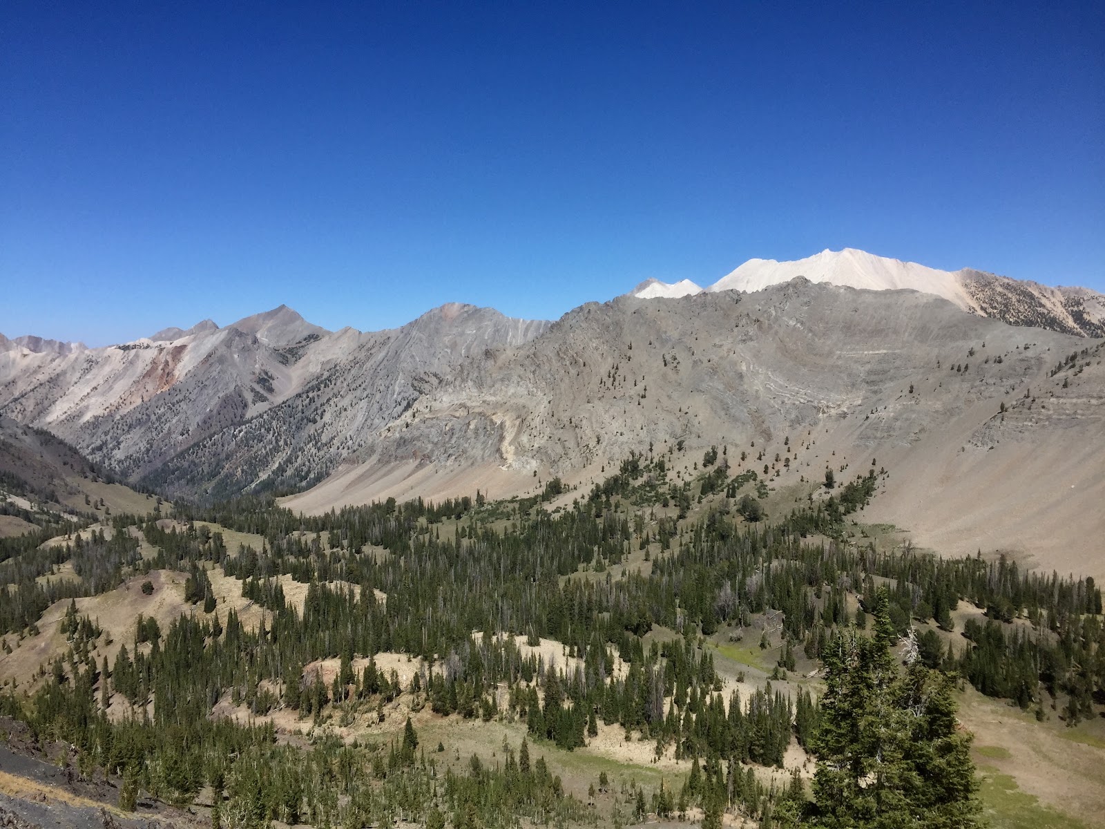
The Sawtooth National Forest in Idaho encapsulates some of the most rugged, unmarked, and stunning wild country in the entire state. Perfectly enough, it is called the “crown jewel”. Throughout my internship here, I have been told continually how dire it is for me to visit this place before my chapter here closes. It is because of the numerous high alpine lakes, 50+ peaks over 10,000 ft, and the multiple wilderness areas that surround the forest. There is an abundance of wildlife, mature tree stands, alpine wildflowers, and solitude. The peaks are jagged and profound. The water is crystal blue. The high valleys are dotted with subalpine meadows and wetlands. I promise you, it is as dreamy as it sounds. With our primary work being for the Caribou-Targhee National Forest, we were floored when we were given the opportunity to head over to the Sawtooths to assist with whitebark pine (Pinusalbicaulis) monitoring surveys.
Looking directly into Strawberry Basin. To the right, notice the white mountain. One of many, these prominently white rocks compiled to form what we call, the White Clouds.
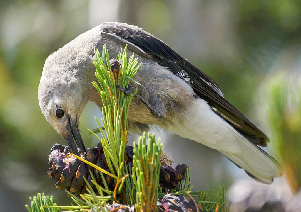
Whitebark pine is a species of interest due to the impacts of native mountain pine beetle and white pine blister rust. Both continue to successfully reproduce across western forests and cause decline in whitebark pine. Additionally, whitebark pine is experiencing regeneration challenges as continued fire exclusion limits seedling establishment and allows succession to shade-tolerant species. This species thrives in subalpine environments and co-exists with other dominant conifers such as: douglas-fir (Pseudotsuga menziesii), engelmann spruce (Picea englemannii), subalpine fir (Abies lasiocarpa), and lodgepole pine (Pinus contorta). Not only do whitebark pines coexist with stunning conifers, they also have a close relationship with the Clark’s nutcracker. The nutcracker is an essential partner in the regeneration success of whitebark pine. These jay-sized, grey, black, and white birds favor using their broad beaks to remove seeds from pine cones and distribute them across the landscape. They will collect thousands of seeds and bury them in cache piles as far as 20 miles apart. This natural distribution of the seeds is hugely crucial to the species. If you are fascinated by these birds as much as I am, learn more from the Audobon at https://www.audubon.org/news/better-know-bird-clarks-nutcracker-and-its-obsessive-seed-hoarding.
Clark’s Nutcracker acquiring one of many seeds. Photo by Marshall Hedin.
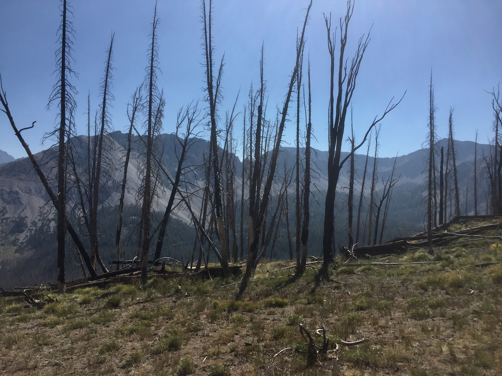
The White Cloud Mountains continue to expand whitebark pine research. The monitoring surveys we completed were created to analyze how they regenerate post fire. In 2006, the Valley Road Fire burned nearly 40,000 acres in the White Cloud Mountain area. A substantial percentage of the fire occurred in prime whitebark pine habitat. The fire burned at low intensity and high intensity changing the entirety of the environment. Our survey focus was overall forest health and vegetation reestablishment. We visited over 20 plots in five different stands throughout the White Clouds, collecting data on a variety of components.
Some to note would be:
Tree status – dead, alive, or infected
What killed the tree
Fire evidence
DBH and tree height
Number of overall conifer regeneration
Complete vegetation survey of each plot – forbs, graminoids, trees/shrubs
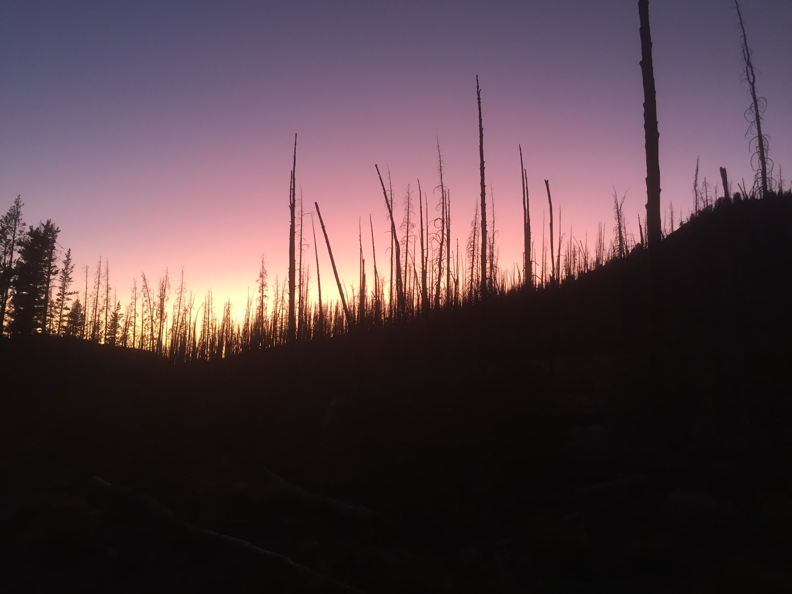
In the heart of one of our many plots. This is a mixture of subalpine fir and whitebark pine skeletons from a previous fire.
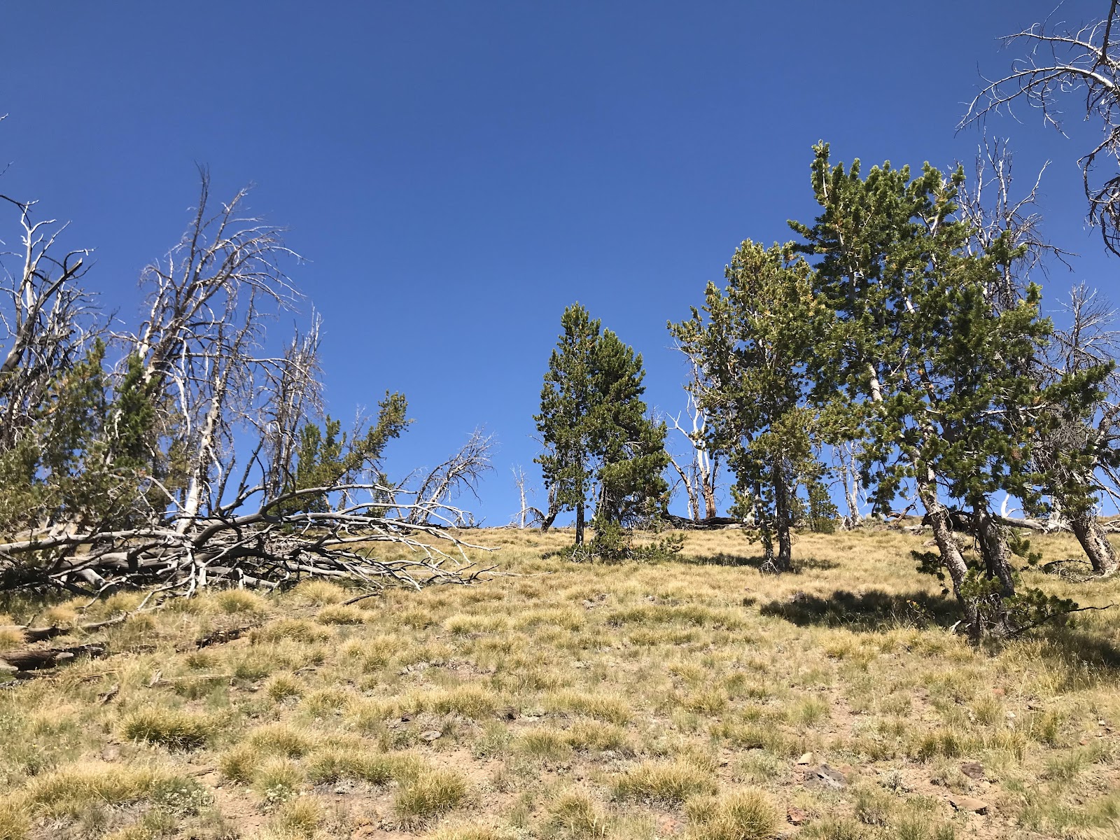
Each plot provided a different representation of how the forest can respond and how resilient it is to the impacts of wildfire. Here we were, thirteen years later, seeing thriving wildflower communities, tree regeneration, hearing the wolves cry, and elk bugle. Analyzing these snippets of the massive area we were in, provided us with a small window into just how adaptable forests are and how beneficial fire can be. It is important to note that we did find evidence of both mountain pine beetle kill and white pine blister rust, which was to be expected. Collecting this data will hopefully provide a continued baseline of what changes are occuring between each sampling year and will promote future management decisions.
A moderately healthy whitebark pine stand. Photo by Olivia Turner.
Lastly, there is something oddly beautiful about being wrapped up inside of a 40,000 acre burn scar. You are completely exposed and can see each and every ridge around you. There is no hiding behind the skirt of subalpine fir or spying on a herd of elk (because they saw you miles and miles before you caught a glimpse of them). It is humbling. These four days flew by. We drove away with the understanding of how to properly conduct these surveys and have hopes to share the techniques with our forest, the Caribou-Targhee.