Fist-bumping, bro-hoofing, or BLM legending, whatever you call it, were common ways to express the overjoyous feeling of ES&R monitoring well done, sir.
From where do I begin to summarize my internship experience this summer? From the quiet humble beginnings of plant identification, preparations, and map-making to the desert-trotting antics of a knowledgeable and thorough ES&R monitoring machine, the summer presented a vast array of challenges that we systematically overcame. Without the help and support of my fellow intern, Justin, and the Burns District BLM range staff, my internship may have been much more frustrating than it was rewarding. The range staff was immensely helpful this summer with plant identification, navigation, and monitoring protocols. Additionally, I feel as though I have made lifelong connections as a result of this internship.
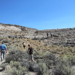
Photocard after Photocard, Transect after Transect, the ES&R Monitoring Crew of the Burns District BLM gets the job done, and done right 95% of the time, every time! All in all, ES&R crew was responsible for all fires which received some form of treatment over the past 3 years. For the Burns District, this meant monitoring and reporting on 7 fires; DSL, Miller Homestead, Lamb Ranch, Holloway, Desert Meadows, Slope, and Smyth Creek.

After searching for over an hour, the mysterious trendsite of invisibility was located and read for the first time in nearly 30 years!
The turning point of my internship was most likely our first major monitoring assignment; the Miller Homestead Fire. This was the second largest fire of 2012 in the Burns District, and received a vast array of treatment techniques through the use of ES&R Funds. More than 5 treatments were used; aerial chemical treatment, aerial seeding, high risk seed mix, extreme risk seed mix, and sagebrush seeding among others. To evaluate the effectiveness of these treatments, at least 25 trendsites were monitored on this fire alone, crossing both resource areas in the Burns District.

I destroyed 2 pairs of boots this summer hiking around the rough terrain of Burns.
This is where I learned the true value of calibration, organization, and teamwork. Many plots had to be separated out by treatment type, and figuring out what treatment took place where was a challenge in of itself. Figuring out how to navigate to each site, and then ensuring that all of the proper paperwork, supplies, and tools were brought along each day was also incredibly challenging. We eventually figured out the protocols, the checklists, and the processes that needed to take place for accurate, efficient, and safe fire rehab monitoring. Justin and I were truly pioneers in this regard, conducting more monitoring for our district than had ever been done before. This really prepared us for monitoring in the extreme terrain of the Trout Creek Mountains, another mega project we accomplished this summer.

Establishing a trend site like a boss.
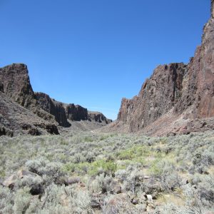
The Trout Creek Mountains compounded the initial challenge of the Miller Homestead Fire. It was early July when we started living and working in the BLM bunkhouse in Fields, Oregon. Everything had to be planned out well in advance. This included having enough supplies to last for a whole week of monitoring, and not just planning a day at a time. Before we left for the bunkhouse each Monday morning, we went through a checklist:
| water |
rebar |
hammer |
carpentry rulers |
Paperwork |
GPS |
pin flag |
| food |
angle iron |
post pounder |
compass |
pencils |
markers |
clipboard |
| radio |
witness post |
density square |
camera |
photocards |
batteries |
Juno GPS |
Once the checklist was complete, we set forth into the field. This involved using work truck to tow a trailer which held our UTV. We would leave by 5:00am at the latest every morning to get a jump start and avoid as much heat as we could, and it was hot working near and over the Nevada border. An additional 25 or so trendsites were read in this steep mountainous terrain. This is where we learned to properly plan to work in an extremely harsh and unforgiving environment. We learned “Proper planning prevents pitifully poor performance” and the importance of communication. For every trendsite read, it was of the utmost importance to communicate with the range conservationist who was responsible for the area. This ensured smoother trend site relocation, accurate history of the site, and proper photo orientation to continue the ongoing dataset of the site.
Once all of the trendsites in the Trout Creeks were “read”, we were given the task of performing additional monitoring throughout the burn area. Sites were randomly chosen with a GIS algorithm, and we loaded over 100 points onto our JUNO GPS. We then systematically went to each point to record perennial plant density, to further evaluate the landscape recovery. By this point, we were essentially the masters of plant identification and ES&R protocols. Within 3 weeks, we had hit all 100+ points in several pastures throughout the Mountains.

We hiked endless kilometers to reach some of our random sample sites.
We then turned our attention toward some of the smaller fires within our district, and began to establish several new trend sites which will be continually monitored for at least another 2 years. Once all of the monitoring was complete, we began data entry, photo organization, analyze data through graphs and figures, and finally end of year reporting. Last week, we finished all of our ES&R reports, and completed a final overall report for the current ES&R year, ON TIME! More recently, we have been preparing files, lists, and protocols for a new batch of interns to take over next year. We noted which plants were found where in the district, and updated a PowerPoint we made of all the plants in our district. Our mentor has already told us how impressed he has been with our work this summer, and that he already has plans to hire CLM Interns next year!
I am leaving my internship earlier than planned in order to prepare for my departure into the Peace Corps! I will be training to become a Sustainable Agriculture Volunteer in Ghana beginning on September 30th, only 26 days away! There is much I need to do before I can depart, but I am incredibly excited about my upcoming adventure. This internship was a great stepping stone between college and my Peace Corps Service, and I had a great experience.
Signing Off,
Dan Mayer
Burns District BLM
Hines, Oregon

Photocard after Photocard, Transect after Transect, the ES&R Monitoring Crew of the Burns District BLM gets the job done, and done right 95% of the time, every time!