Out of the Office and Into the Field

I was getting ready for work Wednesday morning, packing my bag for the field when my phone buzzed on the table. It was an email from our mentor Dean: he had an unexpected and important meeting to attend late morning at the office, and our field work would have to be delayed. Disappointment settled in. We had been putting in a lot of office hours in the month since I arrived at the BLM in Carson City, and Wednesday had promised a full day of scouting planting sites in the mountains. Though I know full well that all this indoor work is a necessary prelude to the field season, I still squirm in my chair by the end of each day, rubbing my computer-tired eyes. Because of the trip’s long drive and hike, a morning’s worth of delay might likely have meant “not today”. At least that was my thought as I begrudgingly changed into jeans (of course I still brought my hiking pants, because you can’t get caught with no work pants on.)

At the office the hours swept by in anticipation, leaving me glancing at the clock and thinking, “At what point will it be too late to leave?” I focused my attention on cartography, and putting my new GIS skills into practice, layered contour lines on top of aerial images to create a clear map of our site. By noon I decided to take a break outside to soak up a healthy dose of apricity, and lull my anxious mind. Just as I was dozing off (yes, I did set a timer!), Anna came out to tell me it was time to leave.

To the Pine Nut Mountains!

20150304_170739

You can see why I was so eager to get here – it’s beautiful!

The TRE fire burned for 5 days in May of 2012, blackening over 6,000 acres of BLM-managed land in the southern Pine Nut Mountains. The high intensity fire killed off much of the perennial vegetation, most notably pinyon, juniper and mountain mahogany. Our goal, as we scoped out this stark landscape, was to find suitable places to plant 400 mountain mahogany saplings. We split into two groups and began the long hike up, up, up, to the tops of our respective mountains. We didn’t come across the charred remains of mountain mahogany until about 7,000 feet, near the top.

20150304_163937

There, over yonder!


Of course, it did take a few minutes to hone our identification skills and distinguish between the different types of charred trees. All of us being new to the area, we had a good sense of what a live mountain mahogany tree should look like, but a dead, blackened one proved more of a challenge. It was an important distinction that would allow us to plant the saplings in a suitable home, and to emulate the pre-fire habitat.

20150304_162837

charred pinyon

20150304_163111

charred mountain mahogany (please ignore the beckoning, snow-covered mountains in the distance, even though my camera’s auto-focus couldn’t.)

The evening sunlight lit up the diaphanous cheat grass, and the radiance temporarily distracted us from noting its onerous stronghold on the land. Weeds seize the opportunity of disturbed soil, burgeoning and preventing native plants from establishing. Hence why it is so important for native plants to reestablish after a big disturbance such as this fire.

20150304_170042

cheat grass at its finest

The two teams reunited en-route back to the car, and thanks to Dean’s keen eye, we got to see a mountain mahogany tree making a concerted effort at regrowth after the fire.

20150304_171905

John and Aaron inspecting a tenacious mountain mahogany

We reached the car, and in the darkening sky watched the nearly full moon rising in the east. Lassitude settled over the rest of the group as we discussed who could stay awake long enough for the dark drive home. I volunteered, still filled with an unequivocal vim from an exciting day in the field.


The Lizard Blog. Tails from the Mojave Desert.

You see this face Steve? This is how I feel about that "Tail" pun.

You see this face Steve? This is how I feel about that “Tail” pun.

All the other lizard jokes he could have made, and that's the one he went with? So disappointing.

All the other lizard jokes he could have made, and that’s the one he went with? So disappointing.

Spring has come to the Mojave Desert! Annual plants are opening their flowers, birds are active and singing, and we’re leaving behind the cooler days of winter (well, relatively cooler, sorry Chicago). Expect pictures and stories about flowers to come soon, but I’m still trying to figure out what all of these new species are. So with this blog I’m going to talk about critters. Scaly ones.

Lizards are some of the most noticeable and most charismatic Mojave Desert fauna. During the warmer months, I could hardly walk 10 meters through the desert without coming across one of these little reptiles. I seldom picked them out as I approached their hiding spots, but when I got too close they would dart away, scampering wildly across the sand looking for refuge. The fleeing lizards were a welcome source of entertainment and movement on the otherwise oppressively still and hot summer days. Most of the lizards here remained active into October and November last fall, spent the cooler winter underground, and have started to reappear in the last few weeks. Allow me to introduce you to some of them.

A western side-blotched lizard. This guy either thinks that I can't see him, or he's trying to decide if he can take me on.

A western side-blotched lizard. This guy either thinks that I can’t see him, or he’s trying to decide if he can take me on.

The most common lizard in my part of the Mojave is the western side-blotched lizard (Uta stansburiana elegans). This extremely abundant species is typically the one that I send scattering as I walk through the desert. These lizards are small, only growing up to 4-5 inches long. They can move with great agility and quickness as they run or hop through boulders and shrubs, which helps them to catch their preferred meals of small insects and spiders. One reason I find lizards entertaining is that they seem to have quite a bit of attitude. The males of several species, including side-blotched, can be territorial, and one of the ways they show-off their dominance is by climbing to the top of a boulder, standing up tall on their four legs, and rapidly doing push-ups. Even as I approach, these guys will sometimes stare me down and continue their push-up routine, showing off how tough they are, until finally I get too close for comfort and they run off. That’s pretty bold for a small animal. I think it’s great.

The western zebra-tailed lizard. Take a look at those great big hind feet with the long toes. Those things make this lizard very fast. A whole lot faster than me.

The western zebra-tailed lizard. Take a look at those great big hind feet with the long toes. Those things make this lizard very fast. A whole lot faster than me.

Western zebra-tailed lizards (Callisaurus draconoides rhodostictus) are another common desert species. Like side-blotched lizards, they are fairly small in size, but show a surprising amount of spunk and affinity for showing off their pectoral fitness. In the picture I’ve shared you can see the dark and light striping on the tail that gives this species its name. You may also be able to see just a little bit of bright color on the belly of this lizard. During the breeding season, their undersides are brilliantly blue, yellow, and orange. Zebra-tailed lizards are one of a couple species that could claim to be the fastest in the desert, and they have a habit of running with their striped tails curled up, adding to the list of behaviors that make lizards charming and comical.

Western zebra-tailed lizard. If you look at the edge of its belly, you can see just a little bit of the brilliant colors that this lizard has underneath.

Western zebra-tailed lizard. If you look at the edge of its belly, you can see just a little bit of the brilliant colors that this lizard has underneath.

Horned lizards are distinctive and widely recognizable, and the species I’ve come across here is the southern desert horned lizard (Phrynosoma platyrhinos calidiarum). Though not as fast or nimble as some other species, their wider bodies and spiny armor give them protection from many predators. And yes, they can squirt blood from the corners of their eyes as a defense mechanism. They don’t do it very often, but all the same, that is one wild behavior. However, their best defense against predators is their camouflage. The coloration of horned lizards will typically match that of their local habitat, mirroring the soil color in which they live. I have only seen three horned lizards during my time here, but I have surely walked past many more without knowing it. Ants are the preferred food for this species, and they have a sticky tongue that helps them to capture their prey.

This is a southern desert horned lizard. You're going to get several photos of this species, because I think they are really beautiful.

This is a southern desert horned lizard. You’re going to get several photos of this species, because I think they are really beautiful.


When I try to take pictures of lizards, they usually make me look very slow and very foolish. But sometimes, if they think they're hidden, they'll sit nice and still for me. Like this one.

When I try to take pictures of lizards, they usually make me look very slow and very foolish. But sometimes, if they think they’re hidden, they’ll sit nice and still for me. Like this one.

I think the color and pattern on their scales is gorgeous.

I think the color and pattern on their scales is gorgeous.

Northern desert iguanas (Dipsosaurus dorsalis dorsalis) are a larger lizard, growing to 16 inches including the tail. This species is also in the running for the title of “Fastest Lizard in the Desert.” Even more impressively, desert iguanas may be able to tolerate higher temperatures than any other North American reptile. They can remain active even during the middle of 120° F summer days. Unlike the other lizards I’ve shown you so far, this species is primarily herbivorous. They eat a particularly large amount of flowers and leaves from creosote bush (Larrea tridentata), the super-abundant shrub that dominates the Mojave Desert.

Northern desert iguana.

Northern desert iguana. You know what it’s thinking? “Hey you, with the two legs. Why don’t you come down here and try to catch me? I dare you.”

The long-nosed leopard lizard (Gambelia wislizenii) is another medium-sized species. They sometimes eat plant materials, but leopard lizards also live up to their name as a predator. They lie camouflaged and hidden in the shade of a shrub, and then pounce on their prey with a burst of speed. They eat insects and arachnids, but larger animals like rodents, snakes, and other lizards are also on the menu. Leopard lizards will cannibalize their own species, and will sometimes go after prey nearly as big as they are.

A long-nosed leopard lizard. The spots and this lizard's appetite for large prey make this lizard's name an appropriate one.

A long-nosed leopard lizard. The spots and its appetite for large prey make this lizard’s name an appropriate one.

I’ve come across a few more lizards, such as big-eyed, nocturnal geckos and the very large, leathery chuckwalla, but I’m afraid that’s all the photos I have to show you. Lizards aren’t always so good about sitting still to have their pictures taken. And there are two species in particular that I haven’t come across yet, but would love to. One is the Mojave fringe-toed lizard (Uma scoparia), a dune-dwelling species of special concern here in California. Hopefully I’ll get to see them as I visit sand dune habitats this spring. The other is the more well-known banded Gila monster (Heloderma suspectum cinctum). With a beautiful, bold, orange and black body, Gila monsters are the largest lizard in the United States, and are one of only a few venomous lizards in the world. They are seen in our field office from time to time, but are not common at all. Of course, I would LOVE to see one, but it’s a long shot. If I do, there will definitely be pictures posted to my blog.

Thanks for reading! Until next time!

-Steve

Needles Field Office, BLM

Why Restore?

When I took this job, I knew it would be a lot of work and a strong learning curve. I’ve never developed a management plan or put in for BPS funding. I really don’t know how much things cost or how much my time is worth. Truthfully, I’m just happy to get outside (not to say that I don’t want to be paid 😉 ). With all this budgeting and NEPA experience, I have really developed an appreciation for how much work goes into planning on the ground conservation, and the intrinsic value of conservation. I wanted to be brief this month, but I’ll leave you with an article on how and why we approach conservation and why we value nature, and if this even valid in the first place.

http://www.huffingtonpost.com/john-a-vucetich/should-we-conserve-nature_b_6722048.html

Post

The past four weeks since my last post have gone by rather quickly. Typically February around these parts is long and grueling with lots of Netflix and scrabble. However, lack of snowy conditions has allowed me to do some fieldwork, fieldwork in the mountains nonetheless! The BLM is authorizing a timber sale in the southern part of our field office and I got to do cultural survey on the 4 or so miles of access road winding through the private surface. The area is a large mid elevation meadow wedged between Gardner Mountain and EK Mountain. A beautiful place where you can see the peaks of the Bighorns to the north and the Red Wall to the south. Unfortunately this is private land with large amounts of “landlocked” BLM lands that the public can never enjoy (unless you have a small helicopter). I really hoped this survey would turn up some interesting artifacts since the foothills of the Bighorn Mountains contain quite a few Paleo-indian (12,000-8,000 B.P) sites. However, not being allowed to stray more than 100ft. from the disturbed road I was surveying did not allow much chance for finding cultural resources. Pretty day, pretty place, too bad no one can enjoy it other than one rancher.


10996791_10101551118343498_7633802154846413085_o

P2120011

Another bit of fieldwork I did was to check out the condition of historic Bozeman trail (http://en.wikipedia.org/wiki/Bozeman_Trail)  signs. It’s always nice to take a drive through portions of the prairie that have had minimal energy development. Most of the signs were in good shape, other than the upgrades made by the local birds.


P1010021


Except for this one.


P1010010

This one is just funny. It is beside Crazy Woman Creek south of Buffalo. Almost every business in NE Wyoming is named Crazy Woman…liquors…water….taxidermy..funeral..accountant…drilling…reality..ect. If you can’t read the sign it says “Two legends give rise to the name of Crazy Woman Creek. Both are based on tragic events. In one, a young woman is left alone after an attach on her village. She lived in a squalid wickiup and on moonlit nights could be seen leaping from rock to rock in the creek. The crow Indians felt that she brought good luck and therefore left her alone. The second legend told of a trader who unwisely sold whiskey or “Firewater” to gain favor with the Indians. When it was gone, the Indians demanded more, which he could not supply. After he was killed, his young wife made her escape, only to wander up and down the creek demented. Because of the loss of her sanity, she was safe from further harm by the Indians. It is said JEREMIAH JOHNSON cared for her thereafter.

In case you’re not laughing, there was never a real Jeremiah Johnson. None of the archaeologists still working at the BLM had anything to do with this sign, but it is too bad members of the public (albeit few go here) may read and believe this.

P1010024


Other than my fieldwork I have been doing some report writing and map making.

– Nathan BLM BFO

Fun with aerial imagery (2)


Hello, world!

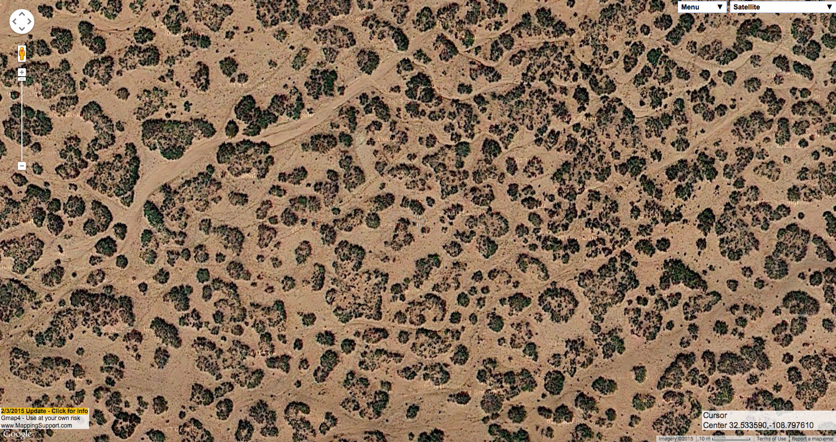
Continuing from the last post, let’s look at Prosopis glandulosa shrubland and some associated plant communities from the ground and from the air. Once you’ve seen enough of it in both contexts, you can start interpreting soil types and associated species from aerial imagery. This has important land management implications. In the Las Cruces District, we have a rare plant (Pediomelum pentaphyllum) that occurs primarily in a subset of Prosopis glandulosa shrubland (a subset which is, luckily, identifiable from the air!). Also, the diversity of associated species and abundance of perennial grasses–both important indicators of the likelihood of success in herbicide treatments intended to restore grassland after grazing has led to an increase in shrubs and loss of grass–can also be predicted from aerial imagery. Double-checking in the field is still critical. However, you can’t be everywhere so, ideally, you check on the ground as much as you can, take photos and notes, and correlate that with aerial imagery to extrapolate to the rest.

So, here’s what Prosopis glandulosa shrubland looks like in its purest form–which usually occurs with little associated plant diversity, very low abundance of perennial grasses, and a relatively firm clay-loam (or loamy clay, or perhaps just clay; I’m not a dirtologist) surface soil.

On the ground:
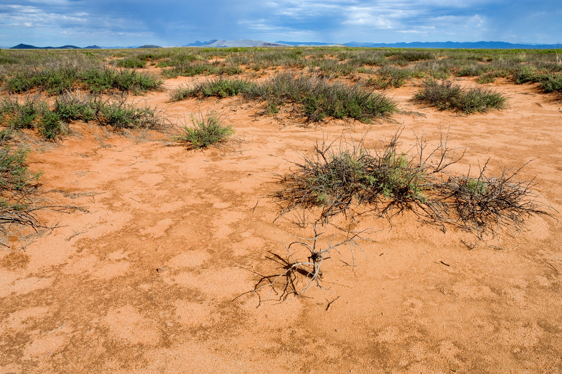
Same site from the air:
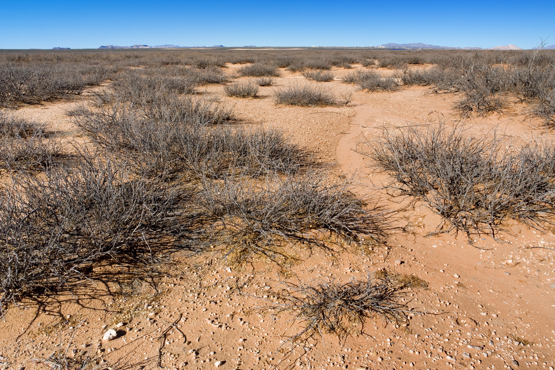
And another example (which you may recognize from my last post), on the ground:
Same site from the air:
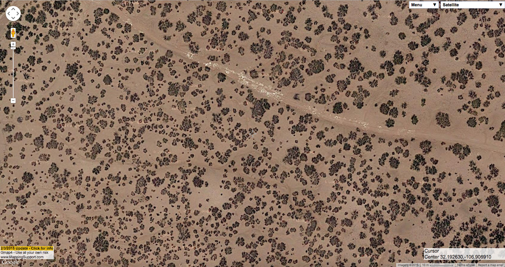
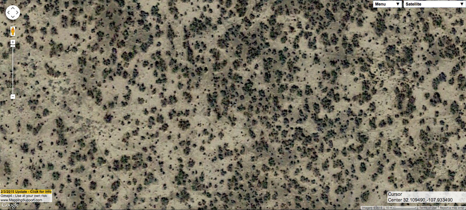
One thing you may notice from both of those photographs is that there is obvious evidence of rills caused by water erosion. This is a good indicator that there is little or no surface sand. In the second example, the exposed petrocalcic horizon along the small road is more evidence of this. The lack of surface sand is a good indication that there is probably little plant diversity at these sites and, especially, few perennial grasses. Sometimes–although not as often–very low-diversity Prosopis glandulosa shrubland occurs at sites that do have surface sand, as seen in the following example. The loose surface sand is very obvious in the field, but also identifiable in aerial imagery by the lack of any rills or gullies caused by water erosion.

On the ground:
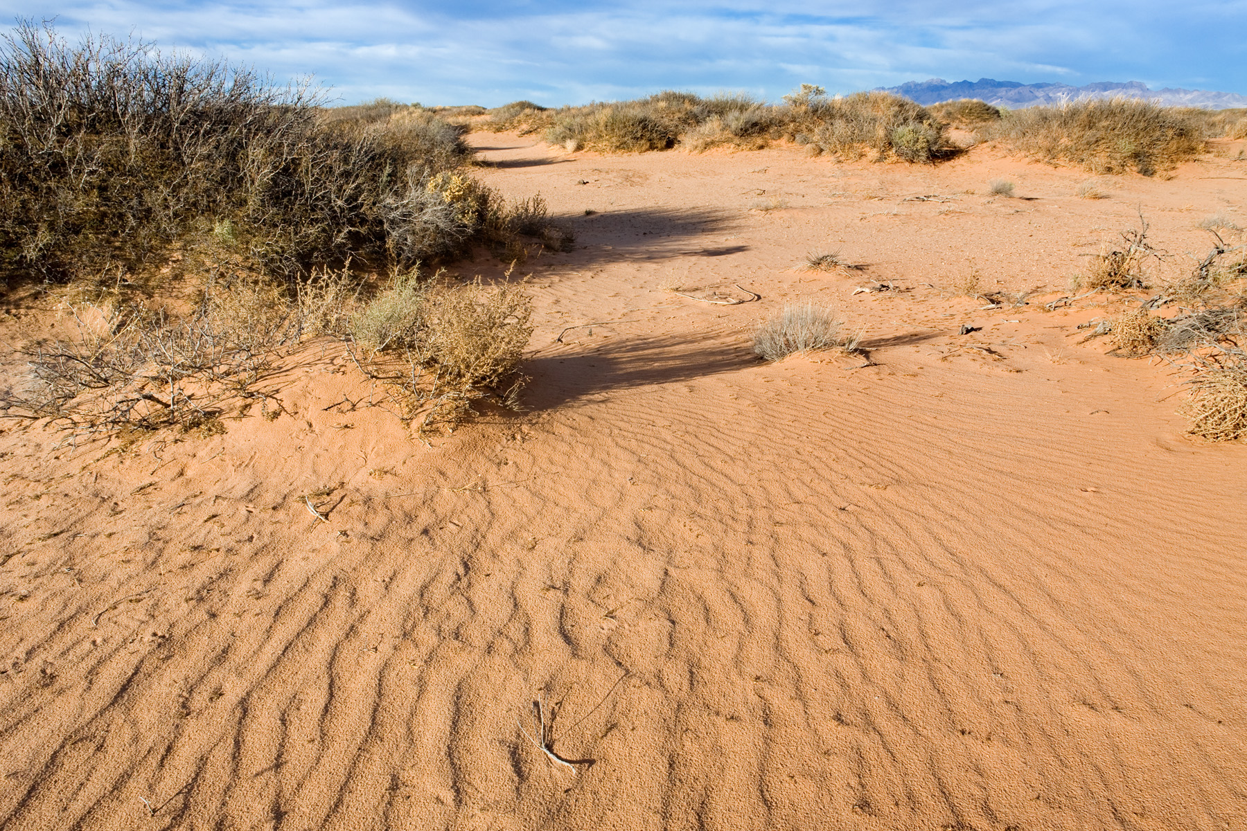
Same site from the air:

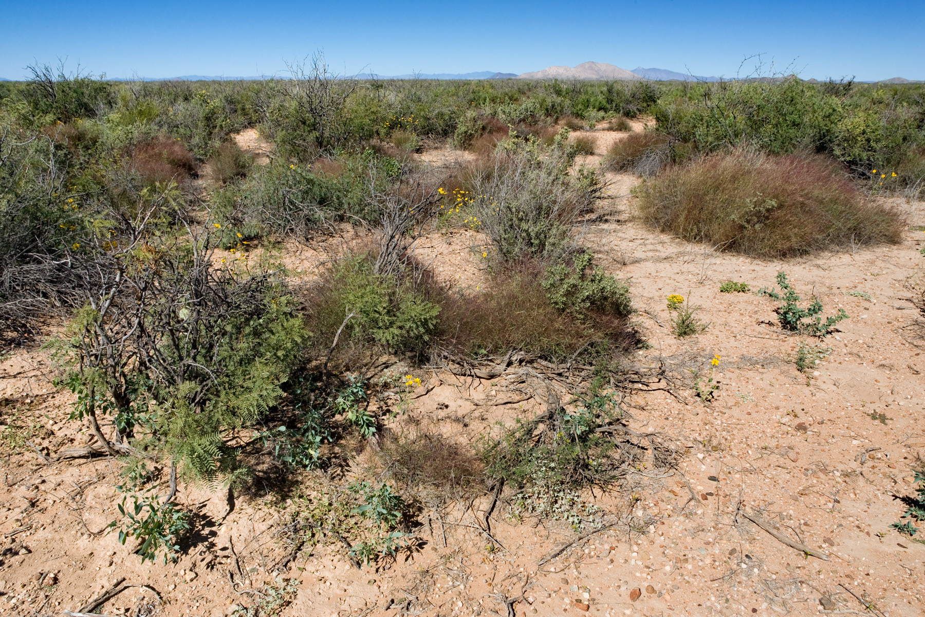
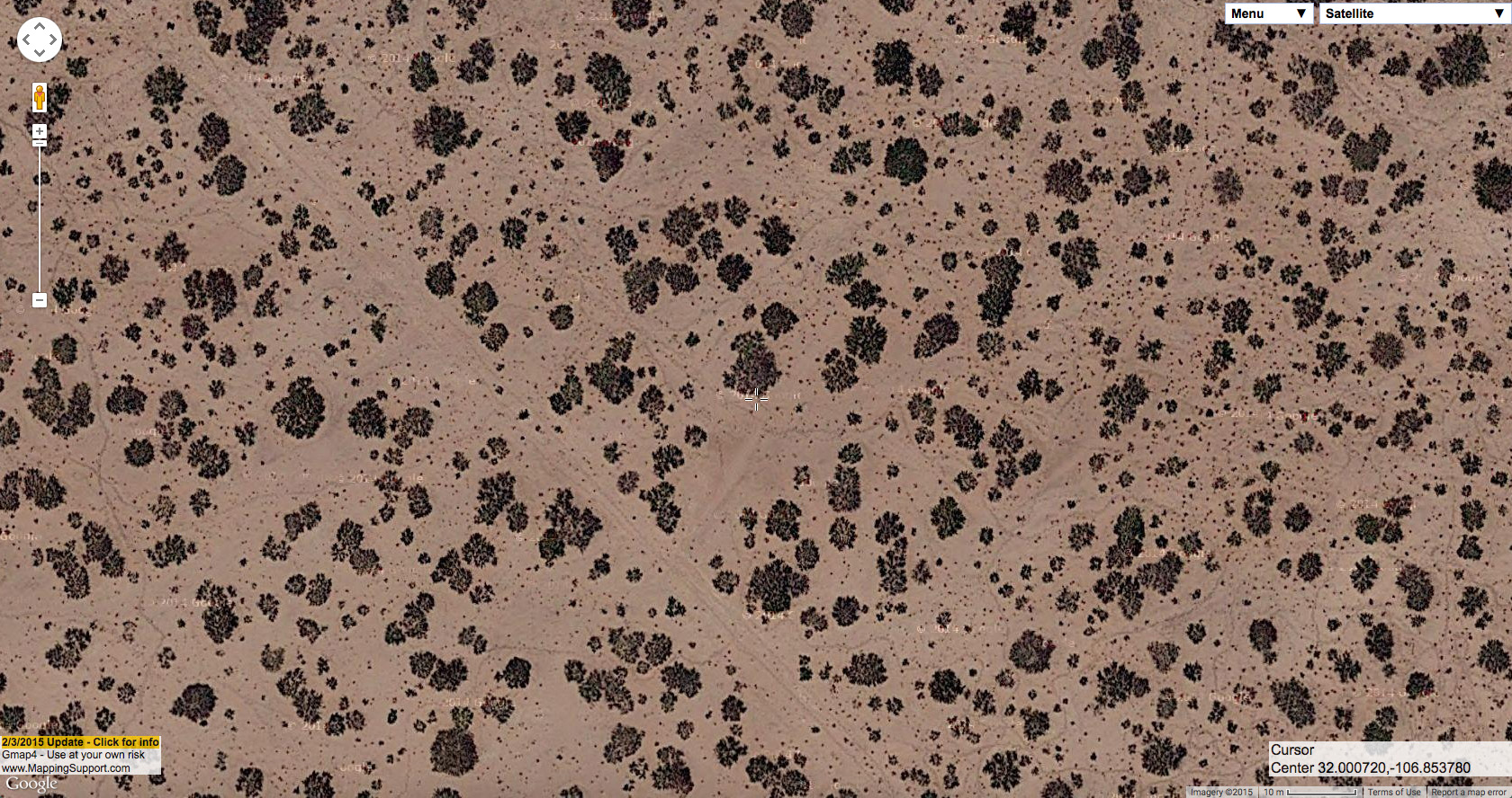
In the first and third examples shown so far, we are looking at Prosopis glandulosa coppice dunes. In this plant community, each Prosopis glandulosa has raised soil around it. It is not clear (to me, at least) to what extent the raised soil of each coppice dune is the result of deposition (soil deposited around each shrub, mostly or entirely by soil particles in wind) and to what extent it is the result of erosion (from both wind and water) in the spaces between the dunes. I suspect that, in most cases, we have a little of each. Most Prosopis glandulosa shrublands in the Las Cruces District have at least some coppice dune tendencies, but you will find Prosopis glandulosa shrubland on fairly level ground without any notable accumulation of soil around the shrub bases. The second example above is intermediate between these two extremes. The following is at the duneless extreme.

On the ground:
Same site from the air:
That form of Prosopis glandulosa shrubland tends to have higher associated plant diversity and more perennial grasses than coppice dunes that lack surface sand, as seen by the big, healthy Muhlenbergia porteri at that site. Prosopis glandulosa also tends to be smaller and more upright in this context. Of course, Prosopis glandulosa shrubland does not always occur in a fairly pure form. Often there are other shrubs or perennial grasses in the interspaces. At the following site, Gutierrezia sarothrae is fairly abundant in the spaces between Prosopis glandulosa, and is visible in the aerial imagery as much smaller dark blobs.

On the ground:

Same site from the air:
Usually, smaller blobs mixed in with the big, obvious Prosopis glandulosa are a good indication that you’re dealing with something more interesting and diverse than just Prosopis glandulosa shrubland. This is not always the case, as in the following example.

On the ground:
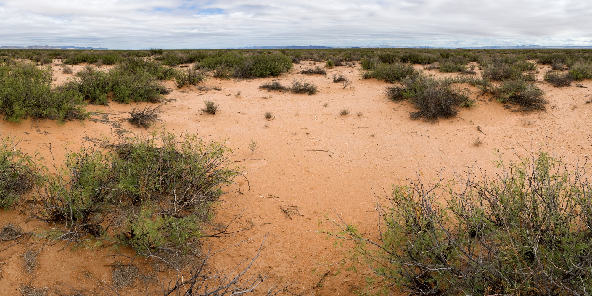
Same site from the air:

A few of the smaller blobs in the aerial image are Atriplex canescens or Gutierrezia sarothrae, but most are Prosopis glandulosa–just younger and smaller individuals. So instead of plant community diversity, they indicate demographic diversity in a single dominant species. More often, smaller blobs are other species. So, here’s an example of mixed Prosopis glandulosa and Larrea tridentata, with a few sprinkles of Gutierrezia sarothrae.

On the ground:
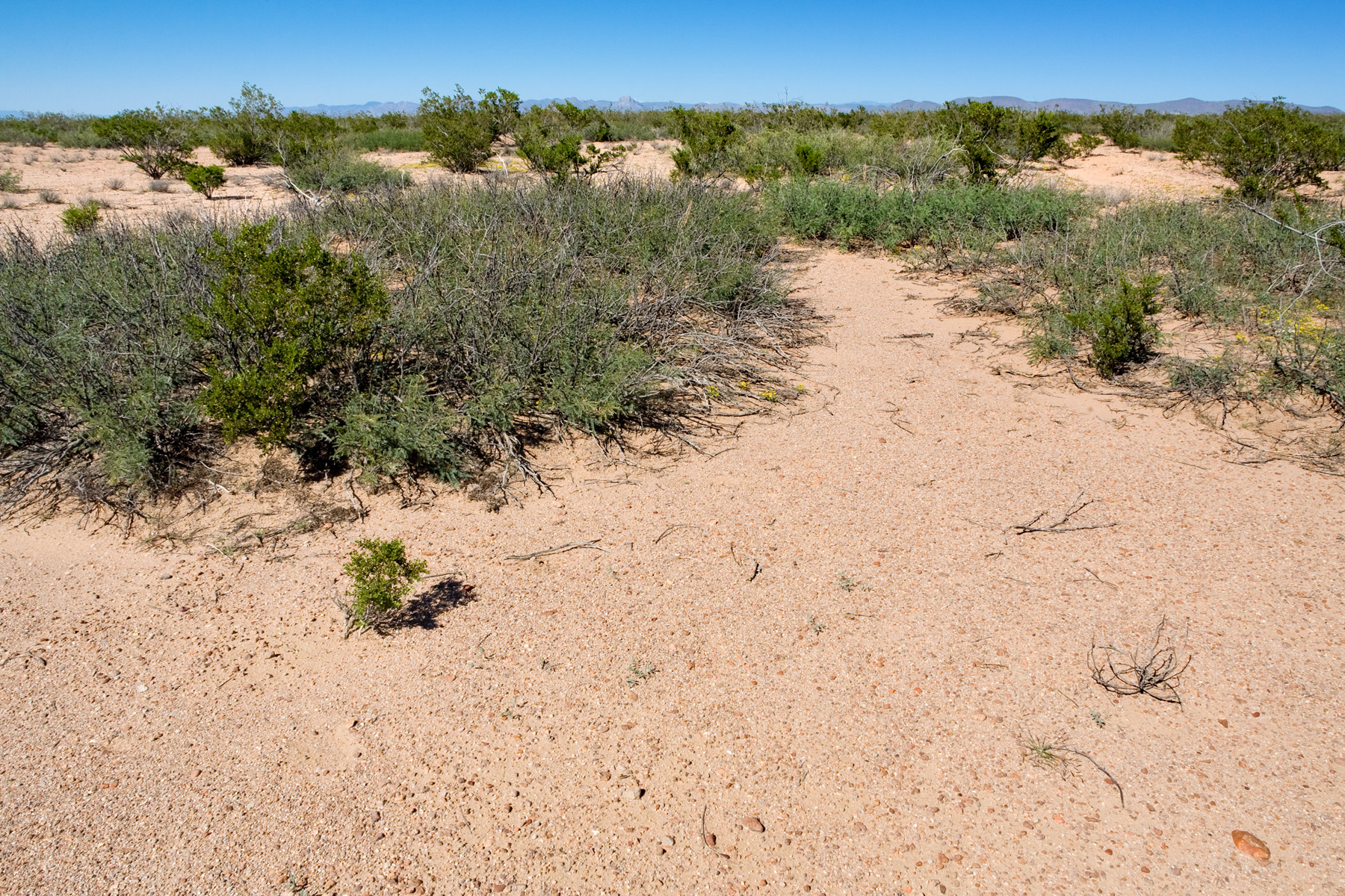
Same site from the air:

Prosopis glandulosa is also often found with Pleuraphis mutica, usually in fine-textured soils without any surface sand, as in the following.

On the ground:
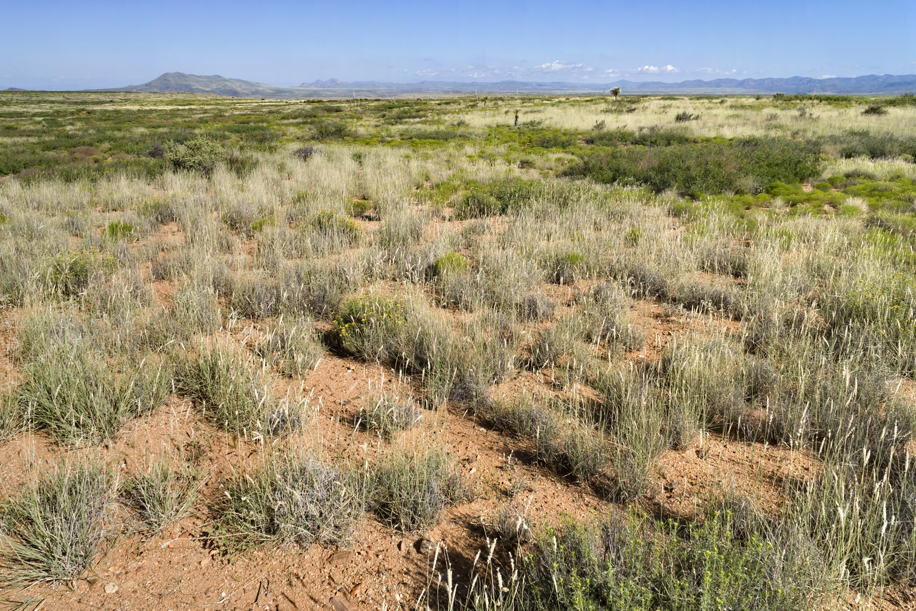
Same site from the air:
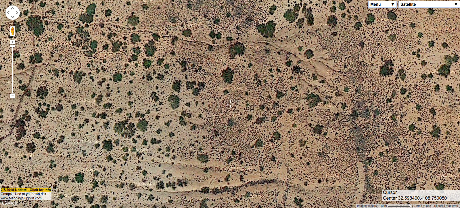
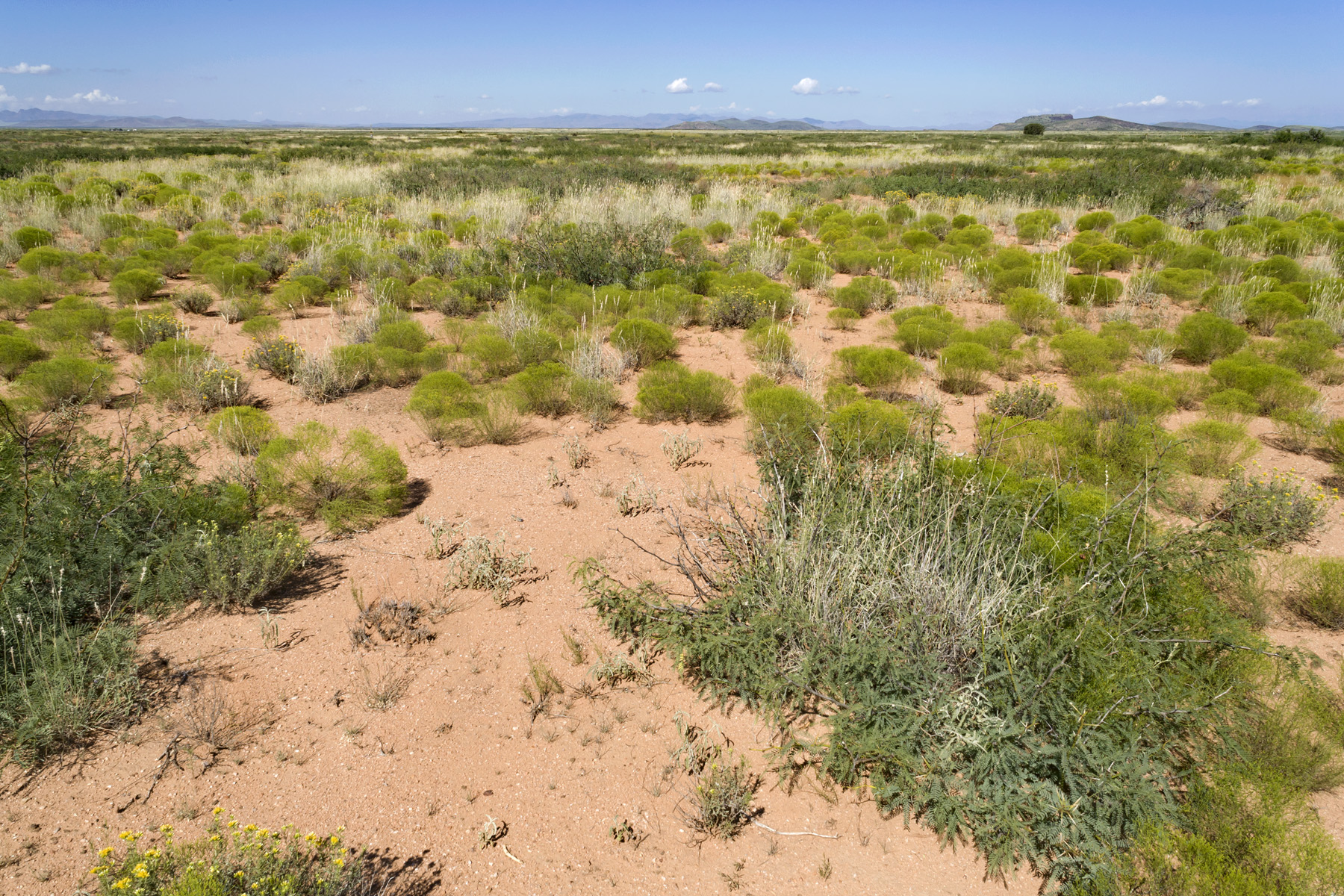
Or, one might find Prosopis glandulosa mixed with Pleuraphis mutica and Gutierrezia sarothrae, as follows.

On the ground:
Same site from the air:
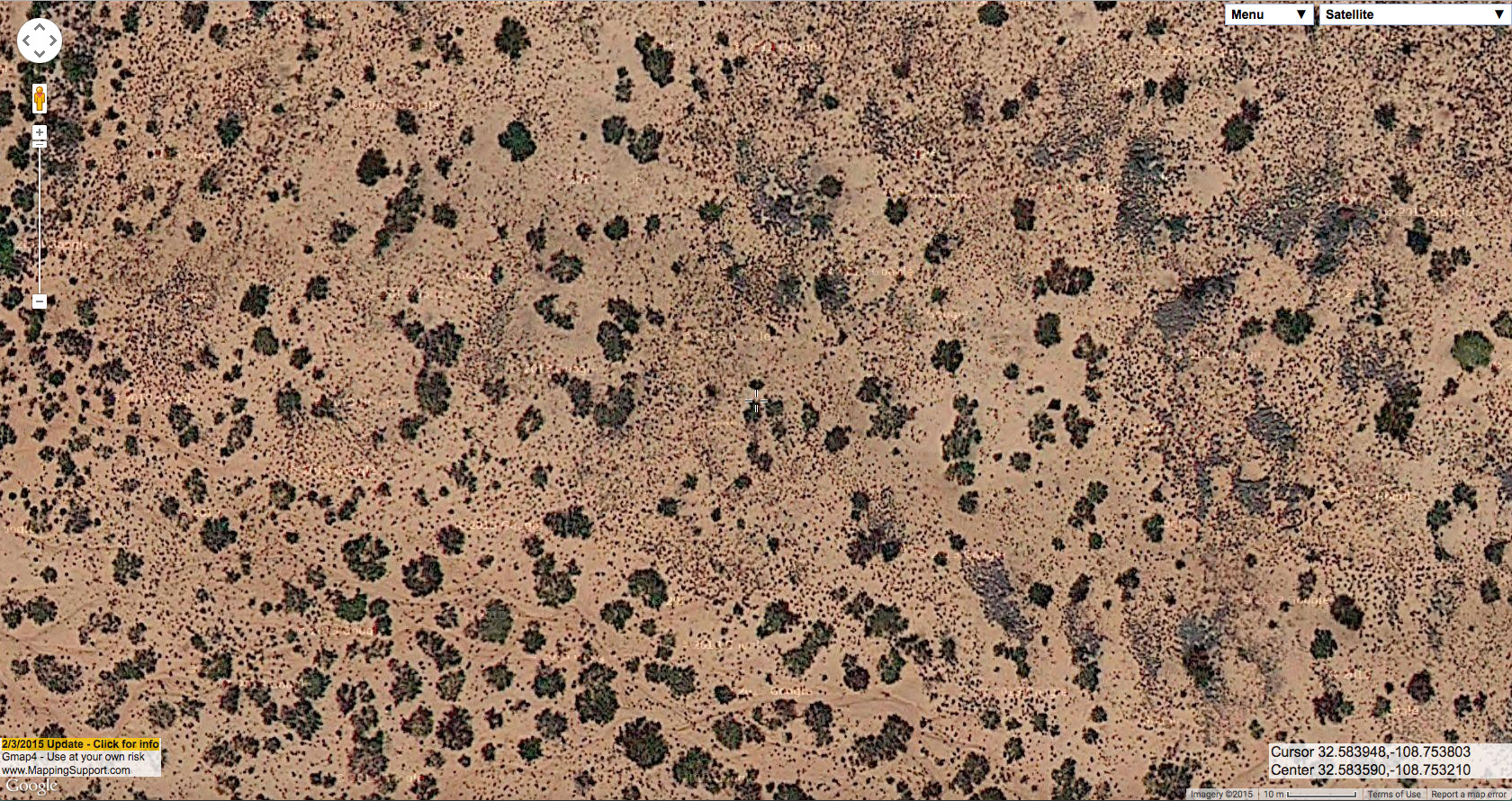
In cases like the two above, I would assume that we are looking at places that were formerly Pleuraphis mutica grassland with few or not Prosopis glandulosa. In the Las Cruces District, Gutierrezia sarothrae and Gutierrezia microcephala are probably the most reliable indicators of recent grazing pressure. However, although they can expand dramatically after relatively high grazing pressure, these Gutierrezia species are not particularly long-lived. Prosopis glandulosa, on the other hand, is usually a very long-lived indicator of grazing pressure. Pleuraphis mutica rarely occurs in areas with much surface sand and is relatively easy to identify from aerial imagery, so its presence is a good indicator of fine-textured, relatively sandless soil. I would also guess that these sites have relatively stable soils; Prosopis glandulosa associated with Pleuraphis mutica rarely has well-developed coppice dunes and usually has relatively few of the rills and gullies typical of pure Prosopis glandulosa shrubland on fine-textured soils.

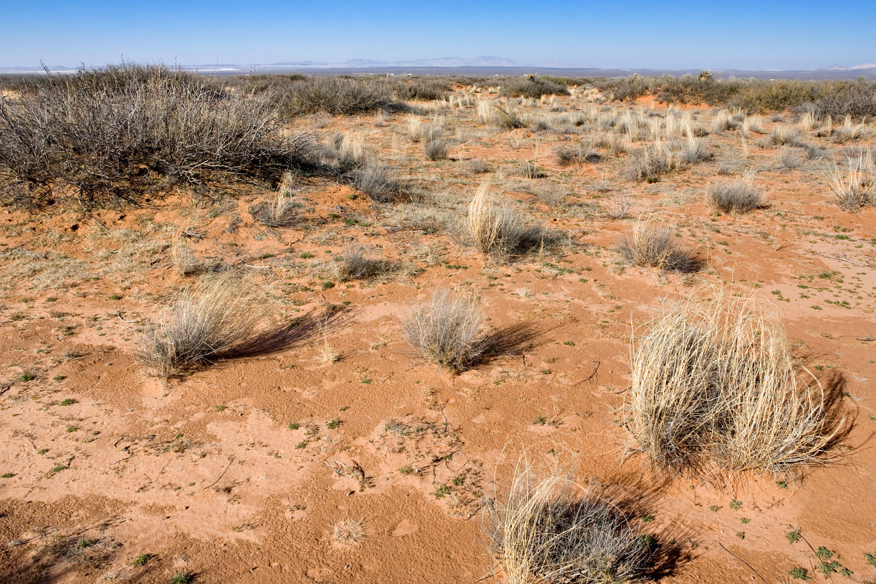
OK, let’s move on to Prosopis glandulosa in areas that have loose surface sand. These are usually higher-diversity sites with more perennial grass. The grass at these sites in the past was probably Bouteloua eriopoda; now it is more likely to be Sporobolus flexuosus. Below is an example of Prosopis glandulosa shrubland with relatively sparse Sporobolus flexuosus.

On the ground:
Same site from the air:
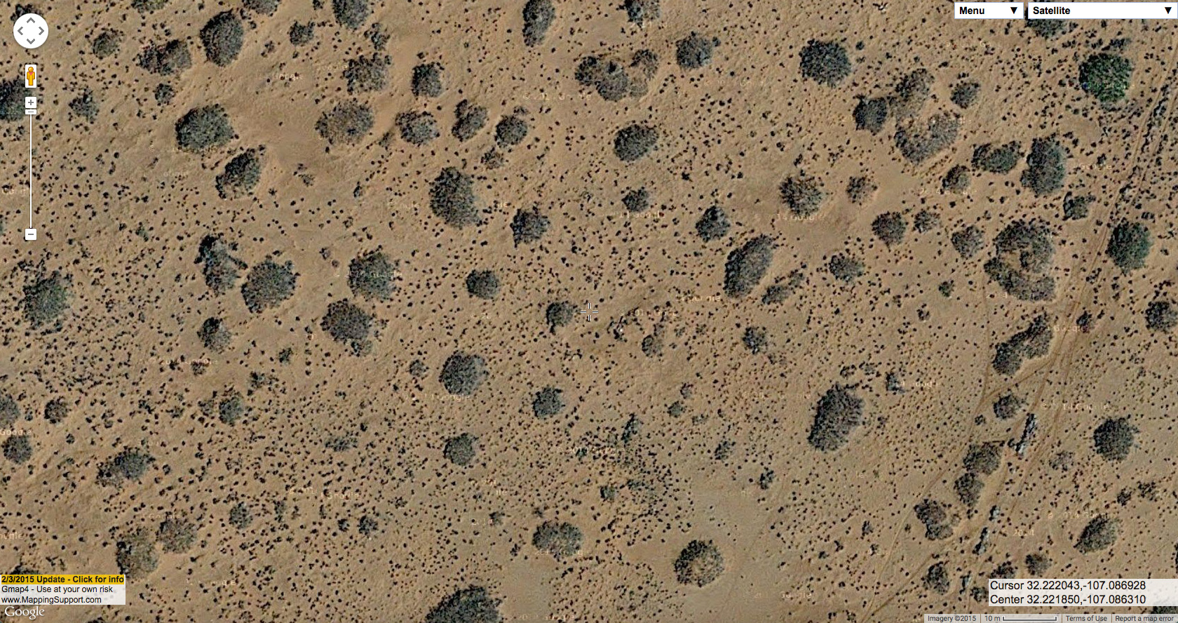
Other shrubs usually associated with Prosopis glandulosa on these sandier sites are Artemisia filifolia, Atriplex canescens, Psorothamnus scoparius, Yucca elata (not exactly a shrub, but we don’t have another good word for it) and, less often, Lycium pallidum or Sapindus saponaria. Below is an example of Prosopis glandulosa with both Atriplex canescens and Sporobolus flexuosus.

On the ground:

Same site from the air:
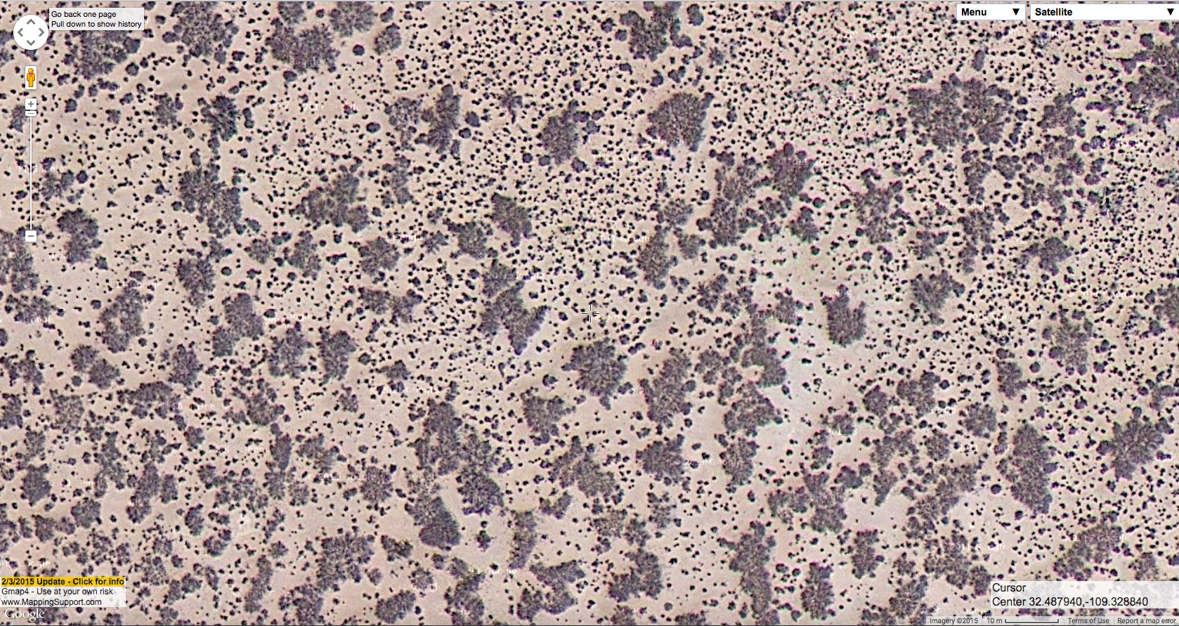
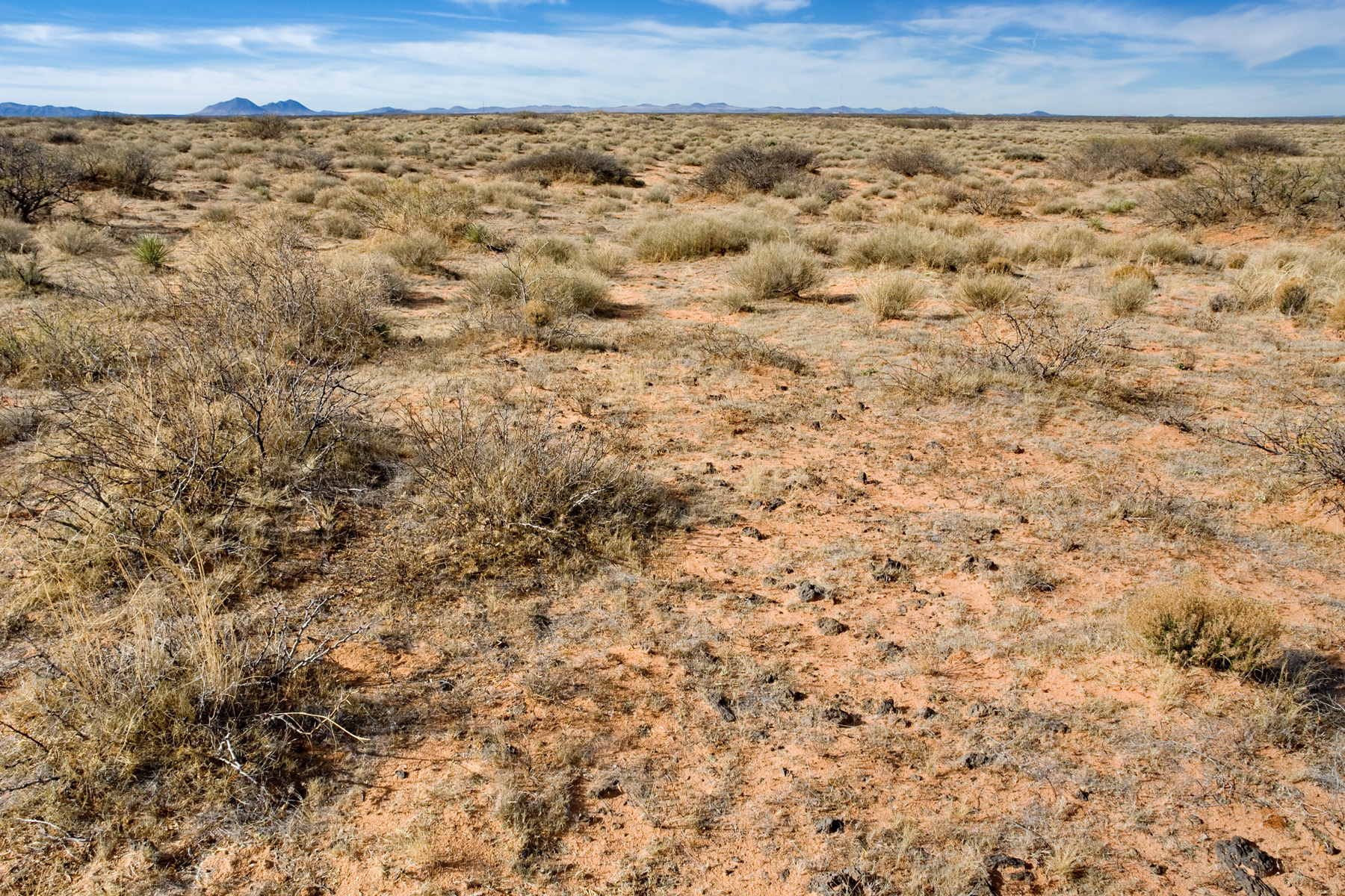
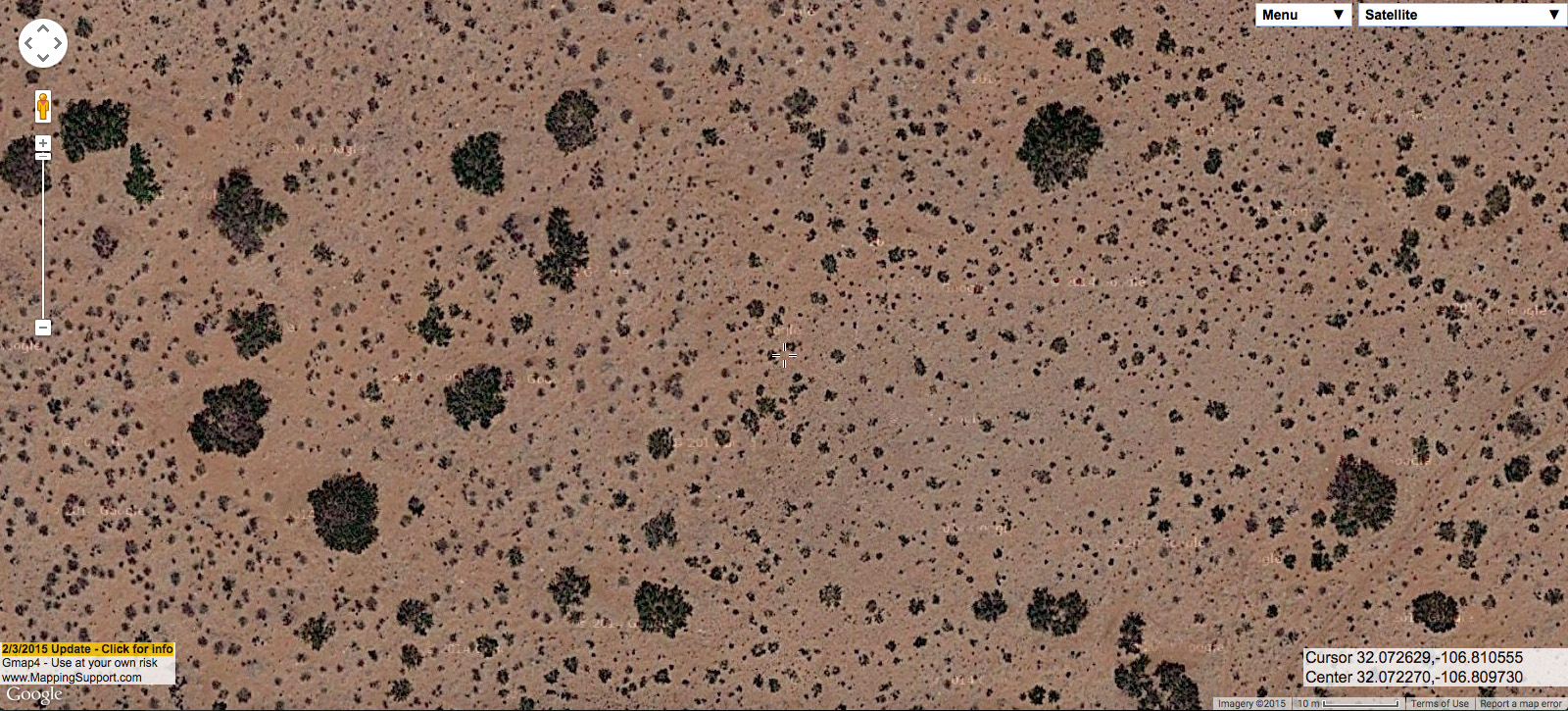
And the following is Prosopis glandulosa with Psorothamnus scoparius. Most of the smaller blobs in the aerial imagery are Psorothamnus scoparius, but a few are just younger, smaller Prosopis glandulosa. The two have very similar morphology as seen in aerial imagery, with Psorothamnus scoparius looking an awful lot like typical Prosopis glandulosa coppice dunes, but much smaller.

On the ground:
Same site from the air:
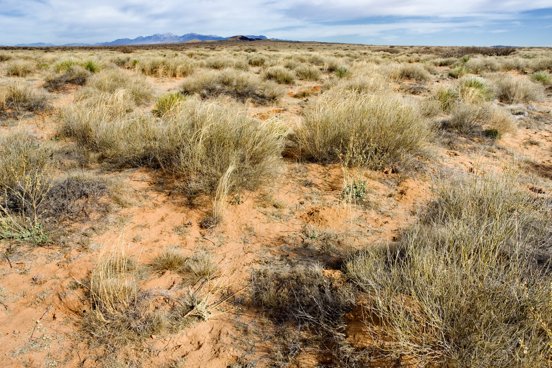
Occasionally, you can also find almost Psorothamnus scoparius shrubland with few or no Prosopis glandulosa, as seen in the following example.

On the ground:
Same site from the air:
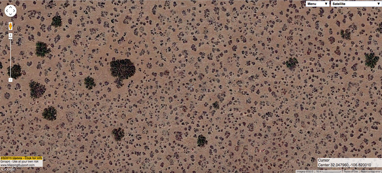
At the high-shrub-diversity end, you might see Prosopis glandulosa, Artemisia filifolia, Atriplex canescens, and Yucca elata all at the same site, as follows.</p.

On the ground:
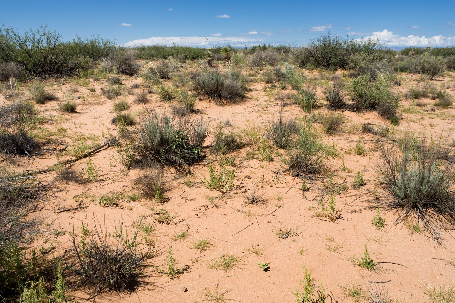
Same site from the air:
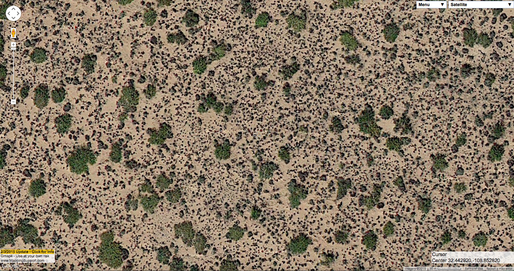
Occasionally, you will even see Prosopis glandulosa mixed with Bouteloua eriopoda grassland–the plant community it has probably replaced at most of these sandy sites.

On the ground:
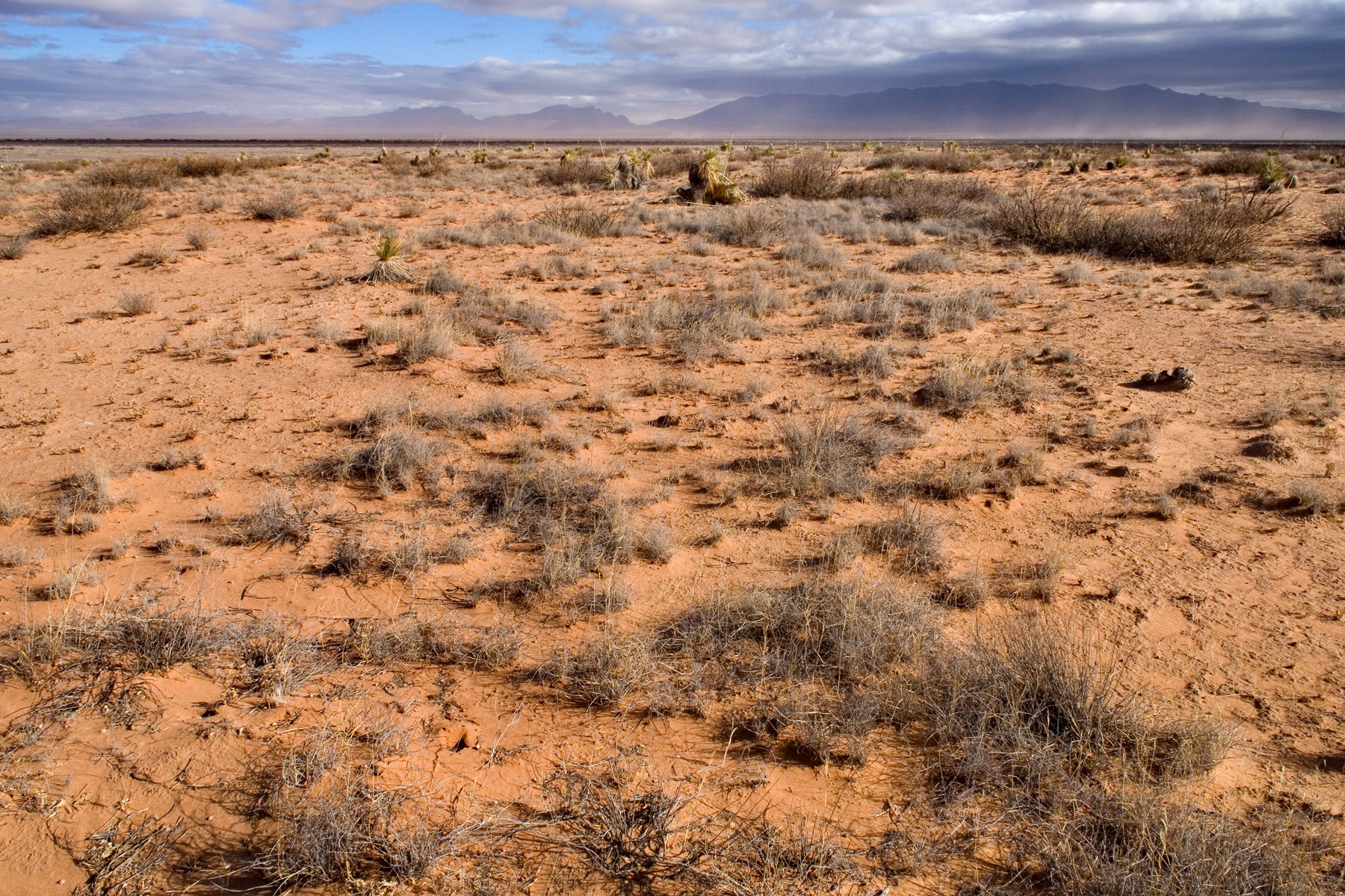
Same site from the air:
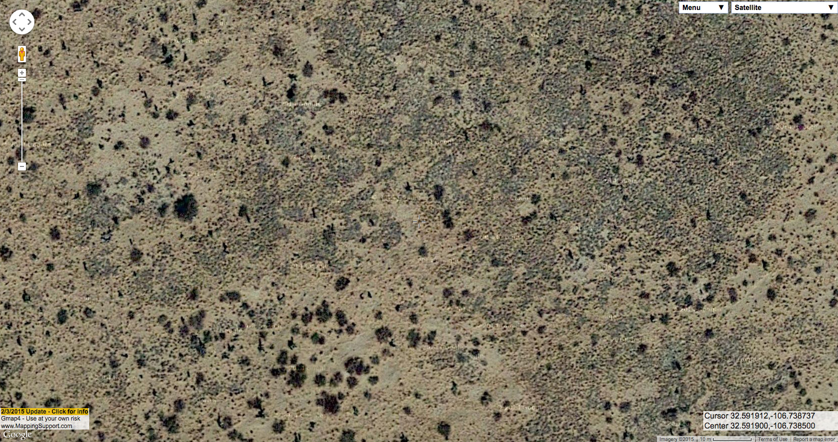
Once you get the hang of some of this, I think you can often get a pretty good guess of the composition, surface soil characteristics, and history of a site with Prosopis glandulosa from aerial imagery. However, everything related to the landscape (and especially, in my opinion, the New Mexico landscape) is incredibly complicated. There are exceptions to everything and thousands of rabbit-holes to go down, both literally and figuratively, in understanding the land. Ideally, this post would go on for at least another 50 pages… but I think neither I nor any readers have the patience for that.

Even office work can be fulfilling

The first half of the week has focused on the mounting and verification of more voucher specimens. These have been collected and identified by the previous Seeds of Success interns, some of whom obviously had a greater proclivity for the process than others. Luckily, verifying these specimens at the University of Nevada’s pristine and spacious herbarium provided many of our group members with an excellent opportunity to further their knowledge of ideal voucher specimen collection techniques. The herbarium curator, Arnold Tiehm, was exceedingly knowledgeable, helpful, and encouraging. He even invited us to attend a 2 day workshop on grass identification later next month.

As the week has progressed, our team has been focusing on furthering our knowledge of ArcGIS. Some of us are more familiar with the program than others, but we can all agree on the fact that it is an extremely powerful and indeed indispensable suite of software for environmental conservation. Another unexpected benefit to this program is that tons of these GIS training classes are offered to us free of charge. Many of these online classes typically cost hundreds of dollars!! An added kicker is that our access to these tutorials persists for a year after we have enrolled in them, affording us the opportunity to continue our studies of the material post internship!!

As the week has begun winding down, our supervisor has begun to assign team leads to several of the specific projects we have been working on. Since my MSc was in Ethnbotany I have been put in charge of collating the existing ethnobotanical data for a couple hundred plants in the region. Documenting the various indigenous usages of different species has always allowed me to commit them to memory much more easily than mere rote memorization. I am extremely excited to encounter more of these species in the field once the warm weather has arrived!

Until next time,

J

Check the Checklist Off My List!

I am so close to being finished with my short-term CLM internship project. The project ended up consisting of an all-inclusive lichen checklist for the four southern-most National Forests of Region 5 aka California. Those National Forests are the San Bernardino, Angeles, Cleveland, and Los Padres. It is a very exhaustive list with all records referenced by the Consortium of North American Lichen Herbaria or publication by an expert lichenologist. My last few hours of my internship will be spent reviewing the checklist and making any necessary corrections with my mentor and the regional botanist who funded this project. After doing this I feel like I know all the southern CA lichens by name, but I still have yet to learn them by sight!

This position actually ended just in the nick of time because I just got hired with a timber company in northern CA doing rare plant surveys. The timber regulations when it comes to conservation are very strict here in California, so surveying usually needs to happen in critical habitat before action is taken on a timber harvest plan. I’m looking forward to experiencing work as a botanist in the private sector. It will be interesting to compare that experience with all of my prior experience working for the Forest Service.

Thanks CBG!

“April Come She Will”

With pictures of summer field work adorning my cubicle walls to guide the way, I hunker down in my office planning away for projects to come.

Since returning from Herbarium work in Anchorage, I have been mostly planning for the busy field season ahead.  On our plate we have:

  • Continued surveys of invasive plant species
  • Soil surveys to be conducted at the end of July
  • Raptor surveys
  • A newly funded Little Brown Bat (Myotis lucifugus) inventory and monitoring project

Much of my end of preparations for raptor surveys has been completed.  These surveys will involve my supervisor and the other office biologist flying along river corridors in the Fortymile region of the interior, in search of raptor nest sites and raptors themselves (hopefully I will be able to get in on a trip). Raptors in this area include: Peregrine Falcons (Falco peregrinus), Gyrfalcons (Falco rusticolus), Bald Eagles (Haliaeetus leucocephalus) and Golden Eagles (Aquila chrysaetos).  I spent some time this fall using ArcGIS to identify suitable cliff nesting raptor habitat.  This involved looking at lots of aerial imagery, and creating GIS layers that might be predictive of cliff areas when aerial imagery was poor or missing (ex. slope, extracting ‘bare’ portions of vegetation layers).  Our wildlife biologist is quite experienced at this and gave me some tips on spotting appropriate landmarks from aerial imagery.  The aerial imagery method is very effective but time consuming and requires experience and practice.  Although it is certainly less selective, I developed some GIS layers that can hopefully help when large areas need to be scanned or can be combined with aerial imagery to make better predictions.

Capture

Aerial imagery showing a portion of the Fortymile river. Red dots mark habitat of varying potential with that bright white curve in the upper middle being prime cliff habitat.

raptor

Layer showing land designated as ‘bare’ in vegetation surveys. Does a decent job at pulling out the barren cliff faces.

slope

Layer showing slope (red is steeper). Identifies steep portions of the landscape which, in junction with the bare layer, can help pinpoint cliffs.


The main project, however, will be bat inventory and monitoring.  I’ll be handling most of the planning/logistics/equipment/study design/field work so although it’s not plant related, it should be a good experience in planning and executing a study.

Little brown bats are the most widespread in North America and one of the only bat species found in the Alaskan interior.  Very little is known about their habitats/distribution/behavior in this area, however, and with rising concerns about white-nose syndrome folks are eager to find out more.

Our first study area will be the Steese National Conservation Area about 70 miles NE of Fairbanks.  It is an interesting study area for bats because 1) it is northerly: bats are nocturnal and the latitude of this location means it gets VERY little darkness during the summer months—civil twilight persists for the majority of the summer with no true darkness and near the solstice there are only about 1-1.5 hours of darkness a night AND 2) it is cold: some research has predicted that 5 degrees Celsius might be the lower limit for some bat activity—nightly summer temperatures in this area could easily dip below this.  Scandinavian studies have found bats at latitudes up to 69N (above the Arctic Circle where the sun doesn’t set for some stretches of summer) with observations that bats will operate when ambient light levels are lowest (even though prey availability is lower at these hours).

For this first season of the study we are mainly testing field schedule/equipment/methodology and trying to see if we can even find bats in this area at all.  The plan is to procure 10 acoustic bat detectors and place them in strategic areas (likely bat habitat) in the SNCA, returning every 3 weeks or so to switch out batteries/download data and move detectors.  We are hoping to capture information on bat arrival and departure, seasonal changes in bat activity, nightly changes in bat activity and preferred bat habitat.  With smart placement of detectors we will hopefully be able to find some bats and pilot study designs that later down the road will provide more robust data on bat habitat preferences.

far

A typical acoustic monitoring set-up from a partner agency’s bat monitoring protocol. The detector itself is strapped to the tree in the foreground and the microphone can be seen mounted to a tall pole in the background.

Right now my computer screen is an explosion of tabs for 12V battery brands, PVC pipe, bat detector prices, occupancy modeling studies, battery physics tutorials etc.  Working out lots of logistics for deploying these expensive pieces of equipment in remote areas.

Katie

Fairbanks, AK

Exciting First Week

Hello All,

This post is coming at the end of an exciting and interesting first week of BLM office in Carson City, NV.  For starters, I think I may have set the record for fastest worker’s comp claim.  At the end of the first day I was cleaning out a Petri dish used to mix adhesive for the herbarium and managed to put a nice cut into my finger requiring a few stitches.  I have jokingly stated that I was just trying to make a splash on my first day.  Work in the herbarium is relaxing and enjoyable.  In the past I have done lots of collecting and pressing of plant samples in the field, so it was nice to learn the back end of the process and be able to produce a herbarium specimen from start to finish.

Of course, my passion is for work in the field.  Yesterday we visited a former mine site, the American Flat Mine, where my fellow interns and I will help to plan and implement a restoration project.  Ecological restoration was a specialization of my MS, and I am very excited about this project.  We spent the day mapping out the area and generating a species list from a reference area nearby.  Being from Colorado, it was nice to be able to pick out several species I was familiar with, while at the same time learning characteristics of many new ones.  I’ll continue to update this project as the summer continues.

Other tasks of the week have included assisting with a cleanup project as part of this office’s Adopt a Space outreach program, sitting in on stakeholder meetings and assisting with research and development of NEPA documents.  It’s only been a few days, but I can tell it’s going to be a great summer!

Wild horses on American Flat Mine

Wild horses on American Flat Mine

IMG_0486

Bank stabilization using willows on TNC property

Bank stabilization using willows on TNC property


Cheers,  Aaron

Big Bear Lake, Jan-Feb

DSCN5730 - Copy

Non-native Bermuda buttercup at Lytle Creek

DSCN5862 - Copy

Unauthorized OHV trails in the Deep Creek area

At the beginning of January, my internship at the San Bernardino National Forest shifted focus; I am now a part of our forest-wide restoration program.  I have been working in our greenhouse in Big Bear Lake and at our lower-elevation nursery at Lytle Creek, and I also have the opportunity to be more involved in the planning process.     

We are continuing work in the Deep Creek area, which involves restoring areas damaged by unauthorized OHV use.  As we encounter them, we are also mapping new sites and unauthorized trails that need to be restored.  The area is predominantly high-desert scrub; common species include Mojave buckwheat, holly-leaved cherry, chaparral yucca, Great Basin sagebrush, antelope bitterbrush, brittlebush (Encelia sp.), yerba santa, and cup leaf ceanothus.  Palmer’s oak is occasional and is always an interesting find.  Wildflower-wise, it looks like it will be a better spring than last year; lots of annuals are starting to pop up, including chia (Salvia colombiare), Phacelia species, Oenothera californica, Calochortus kennedyi kennedyi, and Leptosyne bigelovii.  Beaver Dam breadroot (Pediomelum castoreum), which I mentioned in a previous post as an exciting possibility in the area, is another one to be on the lookout for.

Mountaintop Ranger District

San Bernardino National Forest