Clear Creek looking NE towards the Ciervo Hills
August here in the Hollister field office has seen a continuation of my projects from July: seed collection and processing, and soil collection for the seed bank study. Since I’ve already written about these things, I thought I would say a little about the areas administered by the Hollister BLM office. I have been living in California for 8 years, much of that time on the central coast, and still many of these places are new to me. Furthermore, most California natives that I talk to have neither been to or even heard of that places that I work. I suppose this is not too surprising, as California is a large state and contains so many scenic and fun to explore places. However, the BLM (and surrounding) lands of this area have much botanical, geological, archeological, and historical value…so here’s a shout out to some of the underappreciated BLM lands of Central California:
Panoche, Monervo Dunes, New Idria
Panoche Valley is located in eastern San Benito County and the Panoche Hills are in neighboring Fresno County just east of Pinnacles National Monument and west of 1-5. The Audubon Society describes the valley as a “sparsely-populated and remote region of California consists of vast, grassy ranches that extend up over chaparral and oak-covered ridges, interspersed with dry washes with intermittent water” and designates it as a globally Important Bird Area. (For any other birders out there, a great little blog on a day birding in Panoche Valley can be found at http://shearwaterjourneys.blogspot.com/2011/10/san-benito-county-birding-panoche.html :)) Along with the Carrizo Plain to the south, it is one of the last remaining intact San Joaquin Valley habitats. Most of these habitats have been supplanted by agricultural production, giving this area special significance as a haven for rare valley endemic species such as the Blunt-nosed Leopard-Lizard, Giant Kangaroo-Rat, San Joaquin Kit Fox, and San Joaquin Wooly Threads. You really can’t begin to understand the San Joaquin Valley without understanding the history and significance of agriculture. Good information about agriculture in the Central Valley, water allocation and other environmental impacts, etc. can be found at http://www.epa.gov/region9/strategicplan/sanjoaquin.html and http://www.dfg.ca.gov/wildlife/WAP/docs/report/ch14-cvbd.pdf (especially check out the map on Page 16). According to the DFG the Central Valley has lost 99.9 percent of the historic native grasslands, 99 percent of valley oak savanna, about 95 percent of wetlands, 89 percent of riparian woodland, 66 percent of vernal pools, and 67 percent of San Joaquin Valley shrub lands. Understanding how little of this type of valley habitat remains really underscores the importance of this area. New threats to the Panoche Valley include the proposed Panoche Valley Solar Farm ( http://savepanochevalley.com/environment and http://www.montereycountyweekly.com/weblogs/news-blog/2012/jun/14/proposed-panoche-valley-solar-farm-heads-to-appeal/ ) and shift from dryland farming and grazing to orchards and vineyards. Within the boundary of the Panoche Hills are two Wilderness Study Areas (WSA’s) and an Area of Critical Environmental Concern (ACEC) managed by the BLM.

Panoche Hills (photo courtesy of Tai @ Aerophant.com)
Panoche Valley and the surrounding hills were once part of a vast inland sea. Today fossils of vertebrates such as mosasaurs, plesiosaurs, and marine turtles can be found. This area is also known for it’s mineral and oil resources, including Benitoite (BaTiSi3O9) which was first discovered in here San Benito county in 1907 and subsequently named. It has since become California’s state gemstone. More information on this beautiful and rare blue mineral can be found athttp://www.benitoite.com/benitoite/benitoit.shtml . Panoche Valley is home to a number of ranches and also the historic Panoche Inn (still in operation..mainly as a bar). Recreational uses (besides birding!) include OHV riding, shooting, botanizing (mainly in the spring) and stargazing.
This unique area is often underappreciated, but visiting Panoche Valley this summer has allowed me to feel like I am stepping into another world. When you are there, one cannot believe how close they are to 1-5 and the Bay area! I can’t wait to visit again in the spring and see what it looks like after a winter with some rain.
Monervo Dunes Research Natural Area/ Monocline Ridge

Monocline Ridge
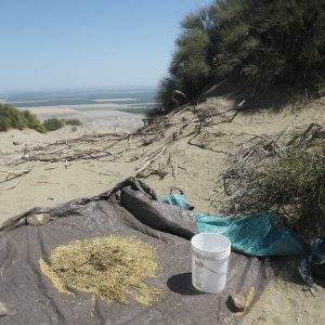
This area is located to the south and east of Panoche Valley in what is known as the Ciervo hills and is accessed from I-5. My time spent here has been for collecting ephedra seeds. During this time I have also found Native American artifacts such as mortars, pestles, and chirt flakes. Hiking around these dunes is grueling, but the view of the central valley is spectacular. The BLM website does a better job than I could of describing this area so I will include it here:
“The Monvero Dunes are characterized as a residual sand ecosystem dominated by plant species that occur in sandy areas in the Mojave desert, including Indian ricegrass (Achnatherum hymenoides), Indian rhubarb (Rumex hymenosepela), and several sand-dwelling annual plant species. Mormon tea (Ephedra californica) is also scattered throughout the sand. The hillsides of Monocline Ridge in the Ciervo Hills are open annual grassland with scattered native annual plants, perennial grass (Poa secunda), and shrubs such as goldenbrush (Ericameria linearfolia) and matchweed (Gutierezzia californica), typical of the Ciervo Hills ecosystem. The Monvero Residual Dunes distribution is narrowly restricted to hilltops and ridgelines along the Monocline Ridge in the Ciervo Hills that occur in the lower Inner South Coast Range in western Fresno County, generally between 1,500 and 3,000 feet elevation. These hilltop sand accumulations are thought to have weathered in place from Miocene sandstone formations in place. These sands have been identified as the Monvero soil series. The residual dunes in western Fresno County on Monvero soils is a special case of a more widespread series, but study is needed throughout the range of vegetation to develop association-parent material relationships. The California Native Plant Society and California Department of Fish and Game identified the Monvero Residual Dunes of the lower inner South Coast Ranges in Fresno County as habitat that is likely to occur largely on BLM land. Several federally endangered species targeted in theU.S. Fish and Wildlife Service’s Recovery Plan for Upland Species of the San Joaquin Valley are known to occur within or along the edges of the proposed Monvero Dunes RNA. These species include the blunt-nosed leopard lizard (Gambelia sila) and the San Joaquin woolly-threads (Monolopia congdonii). The proposed RNA is also within the habitat range of the federally endangeredSan Joaquin kit fox (Vulpes macrotis mutica) and theCiervo aegialian scarab beetle (Aegialia concinna).
New Idria Mine

New Idria Ghost Town
The remnants of this ghost town (much of it has been lost to vandalism and a fire in 2010) can be found south of Panoche and just to the north of the Clear Creek Management Area. Mercury was first discovered here in 1854 and at its heyday in the 1880’s the New Idria had around 3000 residents. Today the area is listed as a superfund site due to contamination from mercury and mine tailings. More information and pictures can be found at http://en.wikipedia.org/wiki/New_Idria,_California ,and http://www.new-idria.org/ .

Laguna Mountain

a view from Laguna Mountian
“The Laguna Mountain Area consists of somewhat rugged terrain with rolling hills covered in dense brush. The area’s vegetation is characterized by classic chaparral habitat, oak forests, and grassy meadows. Laguna Creek flows through the area most of the year, accompanied by a series of scenic waterfalls in the Gorge.” (BLM website : http://www.blm.gov/ca/st/en/fo/hollister/recreation/Laguna.html) This area located between Pinnacles NM and I-5 is certainly rugged to hike around. It contains a number of rare, endemic and well, just really pretty plant species and I have seen a wide variety of birds including Phainopepla, Poor-wills, Bald Eagles, and Hummingbirds. Currently, the trails in this area are under construction (as of August 2012) and are not very well marked, but trail work and new signage are in progress. The best time to visit this area would be the spring in order to take advantage of wildflower viewing and to hike down to the Gorge to see the waterfall. Also, since much of this area has been subject to prescribed fire between 2007-2010, it is currently a good place to see early succession stage fire followers. There is a still a lot to see in summer, but the heat and lack of water and shade do not recommend it for summer explorations! There is free camping at the trailhead.
Clear Creek Management Area and Condon Peak
This area is currently a much contested area in San Benito County. For many years it was a heavily used OHV area until 2008 when the EPA issued a Human Health Risk Assessment for the area that resulted in its temporary closure due to exposure to naturally occurring asbestos. This issue is still being resolved, and an internet search will reveal much information on this topic, but here I want to focus mainly on the natural history of the area.
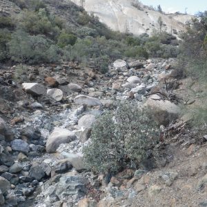
Clear Creek and the New Idria Serpentine Mass

Serpentine Barrens at Clear Creek
Serpentinite is California’s state rock (despite efforts to strip it of its title in 2010). It is a formed in subduction zones and is rarely seen on land. Serpentinite is high in toxic metals and low in nutrients and soils that form from serpentine minerals are usually sparsely vegetated and often contains high numbers of endemic plans. This is true for the New Idria Mass which is the largest exposed serpentenite mass in the South Coast Ranges of California. From the BLM website: “Serpentine soils provide a very rare habitat, occupying less than 1% of the land surface area in California. Serpentine (ultramafic) soils are extremely stressful for plant growth due to low nutrient levels and high levels of magnesium and heavy metals. Plants that grow on serpentine soils often contain special adaptations to tolerate their extreme environment. Some plant species, termed “serpentine endemics,” grow exclusively on serpentine soils. Many serpentine endemic plant species have very limited distributions and as a result are rare, threatened, or endangered, such as the San Benito evening primrose. Serpentine soils often create varied vegetation patterns. Perhaps nowhere else in California is the change in vegetation on serpentine soils more dramatic than at the CCMA where dense chaparral grows immediately adjacent to stark, moonscape barrens absolutely devoid of vegetation. At higher elevations, serpentine chaparral and barrens alternate with conifer forest.”

Clear Creek Management Area
I have spent quite a lot of time on the New Idria Mass surveying for the rare and endemic plants that exist here. It is certainly a remarkable area and, though it is currently closed to the public, worth noting for its unique geology and flora, and its austere beauty.
Condon Peak

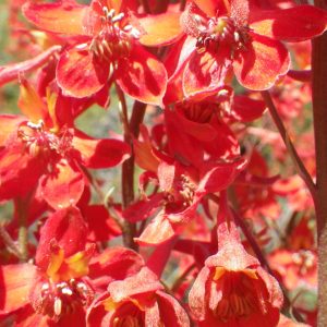
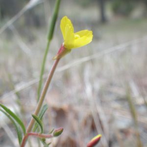
Lupine on Condon Peak, April
Condon Peak is located within the Clear Creek Management Area, but is not in the asbestos hazard area and is still open to the public. At 4,964 feet, it is the 2nd highest peak in the Management area and offers wonderful view of the surrounding hillsides and areas to the south. Spring is especially nice here and offers chances for wildlife and wildflower viewing (including San Benito Evening Primrose). There is a free campsite and a trail that leads to the summit.
To conclude, the value of land is so often seen from the perspective of how they can benefit us either from a production standpoint or as a place of dramatic scenery. While I believe places like Yosemite and the Redwoods are wonderful and valuable places, I also think that we often take for granted areas of our country that are seen as marginal and do not treat them with the respect that they deserve. There are not as many spokespeople for places like the Panoche Hills and the way they are treated by those that use them is a reflection of this. High rates of illegal dumping and vandalism are obvious to those who visit these areas and reflect attitudes of people towards the land. It is unfortunate that we are not able to appreciate these places more.
On a more positive note, working in these areas this summer has reminded me how many relatively unknown and unvisited places exist in our country. They are usually uncrowded and often free and provide many opportunities for exploration. This is true even in a state as crowded as California! A little extra time spent looking at maps and wondering what is out there can reveal many surprises and take one away from the crowds of the national parks and other well-known landmarks to discover your own unique experience.